Elizabeth Street is an east-west street in North Richmond, between Hoddle Street and Church Street. To the west, over Hoddle Street, it links to Albert Street, which hosts separated and then protected bicycle lanes heading into the central business district.

The Elizabeth Street protected lanes in Richmond have a long history since circa 1993 as you can read on this page where we have collated publicly available information, including various reports, meeting notes, Collingwood / Richmond Strategic Bike Plan 1993, Eddingtons East West Link Needs Assessment, Victorian Cycling Strategy 2009, Hoddle Street Planning Study, Yarra Council Bike Strategy 2010–2015, City of Yarra Bike Strategy – 2016 Refresh, officer reports, community consultation, CALD outreach, online feedback and motions for and against included in Yarra Council agendas / minutes.

For historical context, the Elizabeth Street lane trial was first proposed in 1993 by the Collingwood / Richmond Strategic Bike Plan and again by VicRoads back in 2009. The lanes were installed temporarily in 2020 and made permanent at the Council meeting held in April 2023, with provision for final infrastructure to be designed in consultation with Homes Victoria as part of construction and masterplanning works in the local area.

In November 2024 newly elected conservative Yarra councillors introduced a motion that mentions negatively impacting Elizabeth Street bike lanes existance and safety despite considerable input from the community over decades.

This page contains amongst many things, a lot of text, images, links and embedded links so it may load differently on devices or slow connections. Please contact us if you have additional publicly available Elizabeth Street references that can be included on this page.

Yarra Councillor votes in favour of the Elizabeth Street protected bike lanes since 2020: Cr Fristacky, Cr Bosler, Cr Yi Mei, Cr Stone, Cr Coleman, Cr Searle, Cr De Vietri, Cr Wade, Cr Nguyen, Cr Landes, Cr Crossland, Cr Mohamud, Cr O’Brien, Cr Glynatsi.

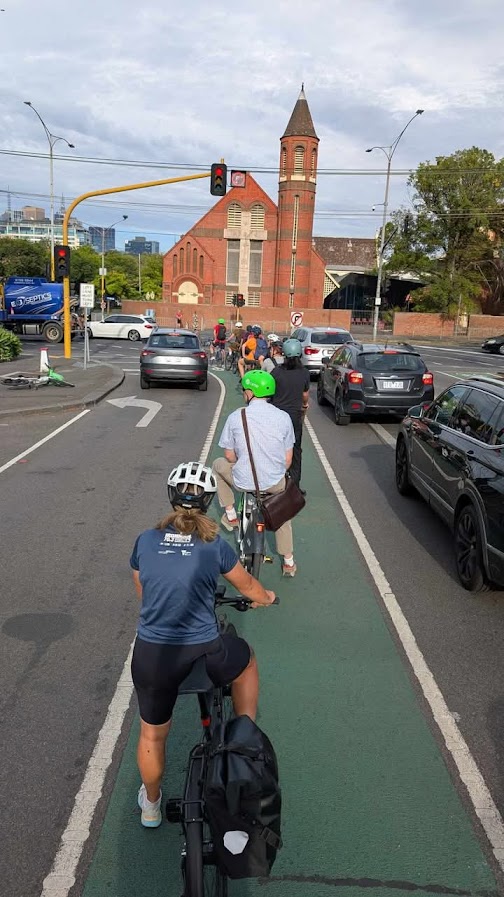
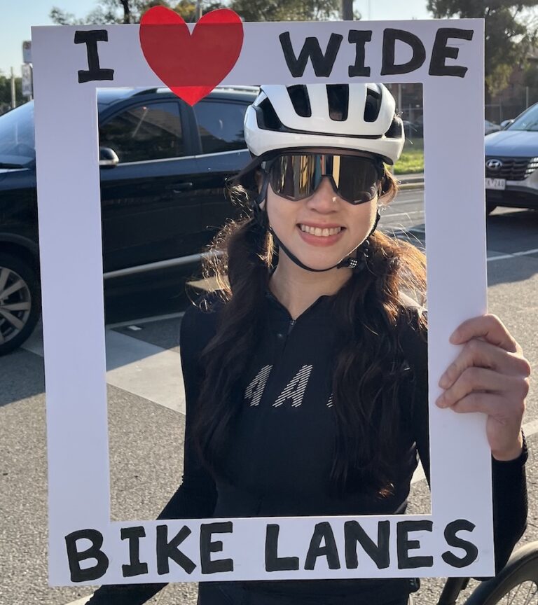
This page exists as a backgrounder to our current Yarra for safe streets campaign as apparently there has been, to broadly quote, ‘no community consultation’ in relation to these lanes, issues raised by community members and accessibility concerns.


Collingwood / Richmond Strategic Bike Plan: Bicycle/parking lanes. (Page 30) Caption: ‘Below: This lane in Highett Street, marked with bicycle symbols, is far too narrow (SBC guidelines recommend 4.0m but this lane is about 3.0m). Note the opened car door which extends to the traffic lane. The question of liability in the event of a cyclist being seriously injured should be of concern to the council.’

1993: Elizabeth Street lane proposed

July 1993: Collingwood / Richmond Strategic Bike Plan: Richmond Non-arterial Road Routes: East West Routes – 6.1 Elizabeth / Baker Street Route (Page 37)
‘This is an alternative route to Victoria Street, particularly for commuters as it accesses Albert Street. It enjoys traffic signals at the crossing of Church Street, Lennox Street and Hoddle Street as well as grade separation underneath the railway line approaching Hoddle Street. The road width of Elizabeth Street at between 14.4 and 15 metres has enabled the provision of bike and parking lanes on both sides. These vary in width from 3.6 metres to 3.8 metres. There is sufficient road width for these kerbside lanes to be 4 metres wide and they should be marked at this width next time the road is resheeted and lane marked. At the intersection with Albert Street, a kerb extension squeezes the route for westbound cyclists. The kerb should be modified as shown to provide a 1.5m bike lane. The outer traffic lane provides for traffic to turn left or go into Albert Street. A cyclist proceeding to Albert Street is vulnerable to a left- turning vehicle. An advanced stop line is proposed as shown so that cyclists are clearly visible to turning traffic’


Collingwood / Richmond Strategic Bike Plan 1993: East West Routes – 6.1 Elizabeth / Baker Street Route


2008: Elizabeth Street mentioned in East West Link Needs Assessment

March 2008: Sir Rod Eddington mentions in Investing in Transport: East West Link Needs Assessment ‘Project 4: A separated bike lane (‘Copenhagen’ style’) along Albert Street, East Melbourne, into Elizabeth Street, Richmond to Church Street. This would provide an eastern link for CBD commuters that crosses Lennox Street – an important north-south route. Estimated Cost: $2 million, total length: 2.5km’

20 August 2008: Yarra Bicycle Advisory Committee Minutes ‘Inner Melbourne Action Plan (IMAP) Task 2.5, There have been three meetings of the IMAP Task 2.5 group. The most important thing the group has done is to select high priority routes to be planned for improvement and (hopefully) separation. The routes in Yarra are: St Georges Road / Brunswick Street, Rathdowne Street, Heidelberg Road, Wellington Street, Gipps / Nicholson / Lennox / Elizabeth, Cremorne rail line path. Council has made some progress on planning separated routes in Yarra.’

2009: Victorian Cycling Strategy + City of Yarra: Bike Lane Separator Trial – Elizabeth Street

March 2009: Victorian Cycling Strategy: ‘Further priority projects under Victoria Transport Plan (VTP) Improve links in Albert Street and Elizabeth Street in line with works to be undertaken by Melbourne City Council.’ (Page 28)

July 2009: From City of Yarra: Bike Lane Separator Trial – Elizabeth Street, Richmond ‘Vicroads is conducting trials into a device which is aimed at providing better ‘separation’ between motor vehicles and on-road bike lanes. Essentially it is a narrow version of the yellow tram barriers i.e located on Bridge Road.The product will be put down on Elizabeth St in Richmond, from Hoddle St back to under the railway bridge, most likely at the end of July. It will be installed on the south side (i.e. westbound lane) and will probably be there for a few months. This is a location that the City of Yarra requested.

To get the most out of the trial, City of Yarra are keen to receive as much feedback as possible during the trial period and will pass all feedback received onto the consultants, SKM, undertaken the trial for Vicroads. It is anticipated that this product will provide considerable benefit to on-road cyclists, by discouraging infringing motor vehicles and improving actually and perceived safety through a degree of physical separation.’

2010: Hoddle Street Planning Study + Yarra Council Bike Strategy 2010–2015

August 2010: Hoddle Street Planning Study: Hoddle Cycling Evaluation Review System: ‘Aurecon, as part of the Hoddle Vision Team, and as a part of VicRoads Contract 7806 – Hoddle Street Study, undertook a Cycling Evaluation Review System (CERS) audit along Hoddle Street, between Swan Street (Olympic Boulevard) and the Eastern Freeway.

CERS and PERS (Pedestrian Evaluation Review System) are dynamic software applications used to assess and audit the quality of any pedestrian and cycling environment, which can assist in the identification of opportunities to improve pedestrian walking routes, public spaces and cycling infrastructure whilst supporting the effective targeting of resources. On site audits were undertaken on various days between 22/03/2010 and 14/04/2010. The area between Swan Street and Alexandra Parade has been investigated, as well as the routes to local train stations.

Hoddle Street was found to be dominated by vehicles, which generally creates an uninviting environment for pedestrians, cyclists and other users. The lane configuration along Hoddle Street varies from three to four lanes in each direction, turning lanes, bus lanes and kerbside parking. Also, Hoddle Street intersects with Swan Street, Bridge Road / Wellington Parade and Victoria Parade, which have through tram lines running east-west across Hoddle Street.’

Yarra Council Bike Strategy 2010–2015: Part 1 | Part 2 ‘Following the completion of Inner Melbourne Action Plan (IMAP) Action 2.3, Yarra began planning separated treatments for some of the “highest” priority routes identified in IMAP. These include Brunswick Street, Heidelberg Road, Wellington Street, Rathdowne Street, Gipps / Nicholson / Lennox / Elizabeth Streets and the Sandringham Rail line path through Richmond and Cremorne.’ (Page 25)


Figure 7.1.1 (b) Strategy 1 – Local Routes – Actions – Yarra Council Bike Strategy 2010–2015 (Page 32)

Figure 7.1.1 (b) Strategy 1 – Local Routes – Actions (Page 33) Yarra Council Bike Strategy 2010–2015

1.3 Richmond East-West Route: 12.5 Appendix 5 – Maps of the Bicycle Routes Yarra Council Bike Strategy 2010–2015 (Page 72)

1.7 Abbotsford/Richmond Route: 12.5 Appendix 5 – Maps of the Bicycle Routes Yarra Council Bike Strategy 2010–2015 (Page 74)

June 2010: Albert Street protected bike lanes constructed in East Melbourne. The future Elizabeth Street lanes are the direct east-west connection through Richmond to the inner east suburbs.

The Age: Good vibrations for new cycle lanes in East Melbourne (6 June 2010) One of the eastern suburbs’ main routes into the city, Albert Street, East Melbourne, will have its speed limit cut to 50 km/h as new bicycle paths become operational from tomorrow.

The new dedicated bicycle lanes run alongside the pavement and are marked with green ”vibra” lines, which causes vehicles to vibrate when they stray into the bicycle lane. The bicycle works have shifted cars away from the curb. During off-peak times, one lane of parking and a single lane of traffic will be available. During peak times – between 6.30am and 9.30am inbound and 4pm and 6pm outbound – there will be a clearway to allow for two lanes of traffic and the bike lanes.

Lord mayor Robert Doyle said the new bicycle lane was a mix of the Copenhagen-style paths which shift cars away from the curb to make way for bicycles and the green vibra line used in other parts of the city such as Rathdowne, Elgin and Queensberry streets. “Our new bicycle lanes on Albert Street show that through simple design changes it is possible to significantly improve safety for riders without disrupting other forms of city traffic,” Mr Doyle said.

The path cost $340,000 to install and adds 2.05 kilometres of on-road bicycle lanes to the cycling road network. There are about 55 kilometres of on-road bicycle lanes and about the same amount of off-road bicycle facilities in the City of Melbourne.’

December 2010: Melbourne City Council: ‘Item 5.4: The purpose of this report is to recommend that the Future Melbourne Committee approve modifications to the Albert Street separated bicycle lane treatment, specifically extending the inbound bicycle lane treatment from Clarendon Street to Powlett Street, and installing a consistent outbound clearway time which operates from 4pm to 6.30pm, subject to VicRoads approval, between Gisborne and Hoddle Street.’

Return to top of page

2015: Yarra Council Elizabeth Street Works: remove the cyclists squeeze point

29 January 2015: Yarra Council Bicycle Advisory Committee Minutes – Elizabeth Street Works ‘Elizabeth Street has just been reconfigured to remove the cyclists squeeze point between vehicles and the fence and throttles the street down to a single traffic lane onto Albert Street allowing Melbourne to fill the missing gap on Albert Street with a buffered bicycle lane for the two blocks westbound. Expect to see the buffered bicycle lanes on Albert Street in the coming months.’

2016: City of Yarra Bike Strategy – 2016 Refresh + Richmond East-West ‘Copenhagen’ style route

September 2016: City of Yarra Bike Strategy – 2016 Refresh – Strategy 1 – Better On-Road Bicycle Network

‘1.3a Richmond East-West (Elizabeth St) Create a fully separated Copenhagen bike lane on Elizabeth Street. VicRoads Strategic Cycling Corridor. VicRoads Strategic Cycling Corridor.

1.3b Richmond East-West (Elizabeth / Baker / Church St Intersection) At the Baker / Elizabeth / Church St intersection install bike head start signal and reconfigure the intersection layout to improve approach bike lanes. VicRoads Strategic Cycling Corridor.’

City of Yarra Bike Strategy – 2016 Refresh – Strategy 1 – Better On-Road Bicycle Network


2019: Yarra Council: Elizabeth Street Bike Lane Upgrades

3 December 2019: Yarra City Council Meeting Agenda: Item 11.6 Elizabeth Street Bike Lane Upgrades

‘Purpose: To seek endorsement for a 12 month ‘iterative trial’ to deliver protected bike lanes on Elizabeth Street. Key Issues: Travel demand in Yarra is rising rapidly as a result of population growth and there is a pressing need to deliver transport projects that respond to this as efficiently and effectively as possible. Cycling has a high level of priority in City of Yarra policy documents with Elizabeth Street being an important local east / west road and also a key cycle route. However, it currently provides a hostile and intimidating environment for cyclists due to narrow bike lanes that place cyclists between parked car doors and large volumes of moving traffic.

There is a long standing commitment to delivering a protected bike lane facility on Elizabeth Street in the Bike Strategy Refresh 2016. In the 2019/2020 budget resolution, Council committed $400,000 for the delivery of protected bike lanes on Elizabeth Street in 2019/20.

The Urban Forest Strategy (UFS) also identifies Elizabeth Street as a high-priority location for tree planting as it is a thermal hotspot, with limited existing tree canopy, significant volumes of pedestrian activity and a large vulnerable population. Taken together, these documents outline a clear long-term vision for this street which includes protected bike lanes and a significant increase in trees and canopy. Delivering transport projects of significance that align with adopted policy is very challenging as it requires the reallocation of busy, highly contested street space which is a sensitive topic in the community.

The Wellington Street protected bike lane project cost $4.5m and took Council nearly ten years to deliver with 11 separate supporting reports tabled for decision makers as part of this process. Contention around possible impacts, and a general divergence of views on various aspects of the project, contributed to the significant amount of time it took to plan for the project before any works could be delivered.

In response to the lessons learnt from Wellington Street, the broader challenges around project delivery and the constrained budget situation, officers propose that an ‘iterative trial’ approach is used to deliver protected bike lanes on Elizabeth Street. This would allow the delivery methodology and the design treatment to be tested before further longer term decisions are made by Council that consider the outputs of the trial. It will also mean that upgraded bike facilities can be installed in the requested 2019/20 financial year timeframe.

Financial Implications

Stage 1 (the trial) would be delivered using 2019-2020 budget resources. Stage 2 (the permanent solution) would require funding in the 2020-2021 or 2021-2022 budget.

Proposal

In summary, the proposal is that Council:
(a) endorses the use of a 12 month ‘iterative trial’ (commencing in the first half of 2020) to deliver protected bike lanes on Elizabeth Street; and
(b) requests a report detailing the performance of the trial, to determine the future state of the bike lanes, within 6 months of the conclusion of the 12 month period.

Purpose

This report details:
(a) the delivery approach proposed to deliver this project to meet the desired timeframe;
(b) how the proposed delivery approach will benefit the Elizabeth Street project;
(c) the capital works recommended by officers from the road design options identified; and
(d) the long term vision for Elizabeth Street and the method of working towards it.

Council has a number of strategies and policies that promote cycling, traffic calming, placemaking, the use of sustainable and active transport and tree planting.

Cycling has a high level of priority in City of Yarra policy documents given it is space efficient, practical, environmentally friendly, convenient, healthy, and cheap form of transportation that aligns with placemaking objectives.

Elizabeth Street is an important local east/west road and also a key cycle route but currently it provides a hostile and intimidating environment for cyclists due to narrow bike lanes that place cyclists between parked car doors and large volumes of moving traffic.

There is a long standing commitment to delivering a protected bike lane facility on Elizabeth Street in the Bike Strategy Refresh 2016. This project would complement the protected facilities installed by Melbourne City Council west of Hoddle Street on Albert Street some time ago.

Alternative east-west options for cyclists in the local area are limited with Bridge Road, Victoria Street and Swan Street all classified as strategic cycling routes but all are busy traffic routes, with trams, narrow bike lanes or non-existent bike and significant car dooring hazards.

In the 2019/2020 budget resolution, Council committed $400,000 for the delivery of protected bike lanes on Elizabeth Street in 2019/20.

Background

  1. Population growth is putting ever increasing pressure on the municipality’s transport network. Simultaneously there is an urgent need to reduce transport related emissions and get infrastructure delivered which gives people genuinely attractive sustainable transport options.
  2. Yarra has long had acknowledged these challenges in its Strategic Transport Statement 2006 and more recently in declaring a Climate Emergency. A further challenge is the pressure on Council budgets which means there is a pressing need for Council to look at ways of ‘doing more with less’ wherever possible in an environment where community expectations are higher than ever.
  3. Project delivery processes and funding allowances for sustainable transport projects have not kept pace with development and population growth resulting in increased congestion, increased conflict between transport modes and a reduction in the attractiveness of traveling by active transport modes and sustainable transport. These trends will continue to worsen unless Council adopts processes and practices that better match the policy intent, so that key transport projects can be delivered more quickly and more cheaply.
  4. New innovative and responsive delivery approaches are required to deliver major bike projects to date. The following paragraphs provide some context around existing delivery challenges for bike projects, lessons learnt and the proposed way forward for this particular project.

Challenges in delivering cycling projects

  1. Wellington Street was the first protected bike lane project to be delivered in the City of Yarra. It has been received generally favourably and is in some respects a signature project for Council with the second phase recently officially opened by the Mayor and the Local Member of Parliament. It is recognised that more facilities such as this need to be provided if Yarra is to improve on its existing seven per cent mode share by bike for work trips to the 15% mode share target by 2015 as stipulated in the 2010 Bike Strategy.
  2. A ‘traditional’ project planning and design delivery approach was used on Wellington Street which featured ‘up front’ extensive consultation, multiple design iterations and a heavily design engineered capital works program. It took Council nearly ten years to deliver this project with 11 separate supporting Council or Confidential Council reports tabled for decision makers, equating to one Council report for every 100 metres of bike lane. Staff resource requirements to produce this volume of supporting material were very significant.
  3. Capital costs were approximately $4.5 million with the majority of funding provided by State Government across the 2 stages. Without external funding it may not have been possible for Council to deliver this project given the financial capacity of the Council.
  4. There are no State Government proposals to fund Elizabeth Street at this time and if a traditional planning, delivery and design approach is taken to project delivery it will not be remotely possible for anything to be delivered within the desired timeframe and allocated budget. If the traditional approach is used it would take at least three years to deliver this project.
  5. A view has been expressed amongst some community members and groups that Council should ‘just get on with it’ when it comes to delivering bicycle infrastructure upgrades, as encouraging cycling is a consistent Council policy position having a long established urban cycling culture (compared to most other metropolitan Council areas) and seeing itself as a leader in the sustainable transport space. The reality is that ‘traditional’ delivery approaches take a great deal of time, particularly for significant cycling projects that require road space reallocation, which is often a sensitive topic amongst some sections of the community. Some members of the community who really want change, believe Council is not doing enough to implement its policies.
  6. Council officers have looked at alternative approaches to the planning and delivery in response to these challenges that have emerged elsewhere. These are a departure from the ‘standard way of doing things’ but are more flexible and can produce often better final outcomes with the initial start-up of the project achieved more quickly and at a reduced cost.
  7. ‘Iterative trials’ are a new, innovative way of working that are steadily gaining traction around the world as Governments look to deliver new projects and new types of project to get desired outcomes in busy urban areas where:
    (a) space is often limited and highly contested;
    (b) wider project impacts and benefits are difficult to quantify and cannot be really understood in advance; and/or;
    (c) community and decision maker opinion is divided to some degree on:
    (i) the potential impacts of a project (be they deemed good or bad on an individual basis);
    (ii) whether a project should go ahead; and
    (iii) what should it look like and what it should do.
  8. All of these aspects were present on Wellington Street which was a complex and a somewhat contentious project for Council to deliver at the time given that protected bike lanes are very rare in Melbourne (albeit common on some other cities). This contention around possible impacts contributed to the significant amount of time it took to plan for the project before any works could be delivered.
  9. It is therefore proposed that an ‘iterative trial’ approach is used for delivering the separated bike lane project in Elizabeth Street. If this approach is successful then it may be rolled out for other Council bike projects in order to progress them.
  10. An ‘iterative trial’ approach (sometimes called ‘pilots and trials’, ‘low-cost rollouts’, and ‘rapidrollout’) offers a method of delivering transport and urban design projects using a ‘low-cost, light-touch,– high-impact’ approach where trial designs can be rolled out quickly and be tested in real world environments before more permanent and costly upgrades are undertaken.
  11. There is already a commitment to providing separated bike lanes on this street in the adopted Bike Strategy Refresh. The trial is about testing the delivery methodology to see how it performs.

A new way of delivering projects

  1. The delivery and transport challenges facing Yarra as a busy inner city Council are not unique and governments and other agencies across Australia and internationally are looking at alternative ways of tackling them. Although ‘iterative trial’ approaches are relatively new to Australia, there are many examples of this type of approach being used overseas with great success.
  2. The most famous example of the iterative trial approach was undertaken at Times Square (in New York) where large areas were converted into a pedestrian plaza using little more than Astroturf, low-cost paint and cheap folding chairs. The results proved highly successful, so it was followed with a second pilot, which involved a mix of permanent paving and a temporary plaza design. A third pilot continued the process installing more permanent fixtures and temporary upgrades, before the final and current infrastructure was installed seven years after the initial pilot. In many cases multiple rounds of iteration are not required but this example is provided to highlight the responsive nature of this approach.
  3. State Government (Dept. of Transport) is now actively considering iterative trial approaches and has been in discussions with Council officers.

Core components to successful infrastructure delivery

  1. There are seven basic components when delivering infrastructure:
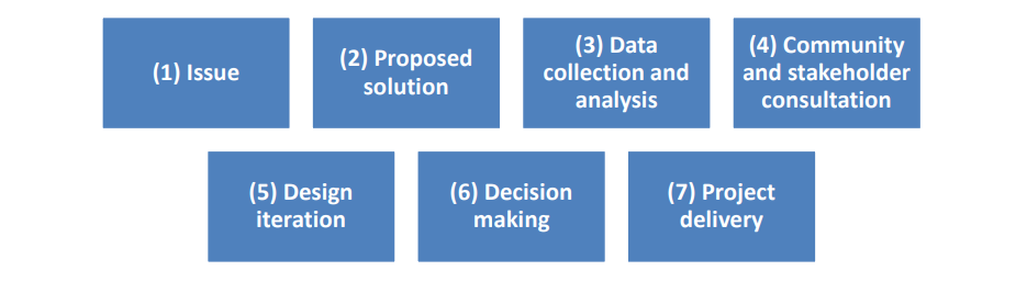
  1. Both the traditional approach and an iterative trial approach incorporate these elements. There are, however, significant differences between when and how these elements (including consultation) are undertaken.

The traditional approach vs. an iterative trial approach

  1. An iterative trial approach is multi-staged and linked to a long-term vision for how something should look or operate. The early stages focus on delivery of a ‘low-cost, light-touch, highimpact’ design to evaluate how it works in a real life setting for a specified period of time (e.g. 12 months). If the trial design is proven to work well following an evaluation process then higher cost, more durable, permanent infrastructure can be installed. In some cases the initial low-cost solution is modified in response to onsite evaluation in the permanent design as part of lessons learnt.
  2. The table below provides a summary of how the iterative trial approach would differ from the traditional approach in the context of delivering protected bike lanes on Elizabeth Street.
  1. For a trial to be viable, the infrastructure needs to be:
    (a) easily altered or removed;
    (b) low-cost;
    (c) fit-for-purpose; and
    (d) able to last the length of the trial without unreasonable maintenance requirements.
  2. Materials fitting this criteria are commonly in use for temporary construction and traffic works.
    Examples include:
    (a) paint;
    (b) temporary removable line marking (line marking tape);
    (c) planter boxes;
    (d) flexible plastic bollards; and
    (e) ‘bolt-in’ kerbs, road humps and lane splitters.
  3. These types of materials are suitable for Elizabeth Street.
  4. It is noted that an iterative trial approach is not appropriate for all projects e.g. where:
    (a) major works would be required to deliver ‘fit-for-purpose’ infrastructure (e.g. bike lanes over cobbled lanes/channels, off-road paths, most rail infrastructure);
    (b) full project funding is already in place (e.g. VicRoads funding) to deliver a ‘best practice’ final design and/or there is consensus between stakeholders on all project aspects (which is rare in transport projects); or
    (c) projects are small, not contentious and where extensive consultation would not ordinarily be required (e.g. installing signage, raised threshold treatments, kerb outstands).

Elizabeth Street: Background

  1. Elizabeth Street, Richmond is a 40kph local road carrying 10,000 vehicles a day and 1,000 cyclists per day that runs east-west between Hoddle Street and Church Street. The route is designated a Strategic Cycling Corridor by the State Government.
  2. To the west of Hoddle Street Albert Street (Melbourne) has protected bike lanes. To the east of Church Street, the route continues along Baker Street and Johnson Street to connect to Victoria Street. Although this is a key cycling corridor it presents a hostile, intimidating environment for cyclists; which discourages cycling outside of ‘the fit and the fearless’.
  3. Kerbside car parking is provided on the north and south, with painted bike lanes between parked cars and a single traffic lane in each direction. It is predominately a residential street with some commercial and mixed-use developments towards the Hoddle Street end. At its western end, a large off-street multi storey (250 space) privately owned undercover car park is provided on Butler Street approximately with parking costs starting from $13 per day. Apartment blocks also exist at this end of Elizabeth Street which contain large amounts of dedicated off street car parking.
  4. The section between Lennox Street and Church Street is flanked by public housing estates on its northern and southern side. These estates contain significant amounts of off-street parking for exclusive use by residents and visitors. The housing estates on the southern side contain approximately 1,000 off street car parking space for residents and 48 spaces for visitors. The housing estates on the northern side contain 138 car spaces for residents and 14 spaces for visitors, DHS staff, emergency vehicles and loading.
  5. Street trees are planted within the footpath between Lennox Street and Church Street. Smaller trees are planted within the footpath between Hoddle Street and Lennox Street with some larger trees (within kerb outstands), along with some small trees within the roadway between car parking bays. Some trees within the roadway have been in place for a few years, but have stunted growth; other trees are young and not well established. Some photos of Elizabeth Street are provided at Appendix 1 to provide further context.
  6. The VicRoads Crashstats database details all injury crashes on road throughout Victoria. The records show that 12 crashes have occurred on Elizabeth Street over a recent five year period. Eight of these crashes involved a cyclist. Cyclists are over represented in the crash statistics as they make up approximately 10% of the daily trip volume but are involved in approximately 35% of the crashes. It is noted that a large proportion of incidents involving cyclists go unreported so do not show up in official numbers. Near misses are also likely to be common and are also not recorded.
  7. Data from the City of Melbourne suggests that bike riders feel 83 per cent safer in protected cycling lanes. Delivery of protected bike lanes on Elizabeth Street would address safety issues and complement the existing protected bike lanes on Albert Street which have been further upgraded to include better separation at intersections. N.B. council officers are also working on separate plans to the east to improve cycling conditions on Baker Street and Johnson Street.

The Long-Term Vision for Elizabeth Street

  1. It is important to visualise the long term vision for Elizabeth Street.
  2. The Bike Strategy Refresh 2016 identifies the need to provide protected bike lanes along Elizabeth Street, and specifically recognises that car parking will need to be removed on one side of the street to achieve this. Cycling levels in Richmond, and in the south-eastern area of the City of Yarra, generally are significantly lower than those in northern areas of the municipality. Differences in the quality of the cycle network between these areas are a key determinant of respective cycling rates.
  3. There is a perception amongst some members of the community that Council is not delivering cycling infrastructure in the south-eastern areas and is more concerned with improving cycling facilities in the north where cycling rates are higher and it is easier to provide better facilities due to the layout of the road network. Regardless of the accuracy of these perceptions, it is clear that cycling facilities in Richmond need to be significantly upgraded if cycling rates are to substantially increase in line with adopted targets originally intended to be reached by 2015.
  4. The Urban Forest Strategy (UFS) also identifies Elizabeth Street as a high-priority location for tree planting as it is a thermal hotspot, with limited existing tree canopy, significant volumes of pedestrian activity and a large vulnerable population. Taken together, these documents outline a long-term vision for this street which includes protected bike lanes and a significant increase in trees and canopy. A concept plan showing the long-term vision for Elizabeth Street is provided in Attachment 1, a cross section provided below.

45. The long-term vision features:
(a) eastbound and westbound protected bike lanes – with car dooring buffer zones, concrete separators with sufficient width to provide general comfort and allow safe overtaking during periods of heavy use;
(b) single eastbound and westbound traffic lanes which are narrowed slightly to reduce vehicle speeds;
(c) significant new tree planting within the footpath, within the bike lane buffer zone and between parking bays (48 new trees in the roadway and 31 new footpath trees); and
(d) green surface treatment at intersections and other conflict points.

46. Road space reallocation would be required to achieve this vision, specifically:
(a) car parking bays on the north side of the street would need to be removed; and
(b) existing (juvenile) street trees within the roadway, and in the path of the proposed protected bike lanes, would need to be removed and relocated.

  1. Council officers have thoroughly considered retaining as many on-street car spaces as possible whilst delivering the long-term vision as set out in the adopted policies. It is noted that all existing mature trees are retained.
  2. The traffic lanes in the proposed design have been narrowed to reduce speed and accommodate bike lanes, however, these lanes still have sufficient width for cars and trucks as per road standards
  3. No changes are currently proposed to the Hoddle Street and Church Street intersections. Both are Department of Transport managed roads and any changes to these intersections would require State Government approval which is likely to be both difficult to obtain without large amounts of supporting justification work and would be very expensive due to engineering works required to change the intersection layout. It should be noted that the cycle lanes in the immediate vicinity of Hoddle Street were upgraded in 2016.

Achieving the long-term vision on Elizabeth Street

  1. Delivering the long-term vision using traditional project processes would mean that the project would not be delivered in the timeframe desired for the following reasons:
    (a) the requirement to reallocate street space and remove some car parking bays would mean a long multi-stage consultation process in an attempt to reach consensus. There may be also some concerns about tree relocation although it is important to note that mature trees providing good canopy cover would not be impacted by this project;
    (b) the potential for ‘decision making inertia’ is relatively high as attempts are made to resolve conflicting positions between providing genuinely safe and attractive cycling facilities vs. retaining car parking. Multiple rounds of consultation and Council reports around these topics would be required which take significant amounts of time to produce; and
    (c) the long-term vision involves significant up-front capital funding necessitating the diversion of budget from other areas, or ‘banking funds’ over multiple years. Delivering a permanent solution now would be a significant capital investment which is not budgeted.
  2. If a traditional approach is used, it would be a number of years before protected bike lanes or new trees in the roadway are actually delivered.

Short-Term Iterative Trial – Options for Elizabeth Street

  1. Three design options for providing protected bike lanes have been identified for the trial at the western end of Elizabeth Street between Hoddle Street and Lennox Street. These options factor in impacts to car parking and trees, and it is proposed that one option is delivered and evaluated on a trial basis.
  2. At the western end each design option aligns with the long term vision and takes a low-cost, light-touch approach so that works can be relatively easily altered or reversed at a reasonable cost if needed. It should be noted that a road re-sheet is scheduled for 2021. This provides an excellent opportunity to either deliver a permanent design if the trial is successful; or remove the trial infrastructure and return the street to its existing layout, following an assessment of the trial.
  3. Each of the three design options (western end) delivers a protected bike lane facility eastbound and westbound and maintain one traffic lane in each direction. The design options differ in terms of their impact on existing car parking bays, straightness of bike lane and trees:
    (a) design option A provides the upgraded bike lanes without impacting any existing trees planted in the roadway. This results in bike lanes that weave in and out between kerbside trees located in the roadway and parking bays which is far from ideal from a street legibility and safety perspective as traffic lanes would have kinks and bends in them. Retaining all the trees would also mean that more parking has to be removed and more space within the street is made redundant and not useable due to lane angles and geometry;
    (b) design option B removes or relocates these juvenile trees from the southern side of the road, but retains trees to the north. This means the same safety and legibility concerns noted above apply to the east-bound bike lane; but the west-bound bike lane is straight and significantly more car parking can be retained; and
    (c) design option C straightens both bike lanes out to provide safer and more attractive bike lanes. This means that more juvenile trees need to be removed or relocated, however, parking removals are minimised and the street legibility would be improved.
  4. Council’s arborist has indicated that if the juvenile trees within the roadway need to be removed for the trial, many of them would be able to be relocated to other locations across the municipality. Any stunted trees are not likely to be able to relocated as they are in poor health.
  5. Typically tree removal or relocation would not form part of a trial as these are at the more permanent end of the works spectrum. However, the trees located in the road pavement that would be relocated as part of the trial are not mature, have a marginal visual presence (see photo’s) and do not contribute significantly to the look and feel of the street at this time. The relocation of these trees would also be required to deliver the long-term vision. On this basis, assuming the long-term vision is delivered at some point, it is more a question of when these trees are relocated rather than if. Following on from this logic, if trees need to be relocated it makes more sense to do this now as part of the long term vision before the trees grow and establish themselves making it either more difficult or not possible to relocate them.
  6. The visual impact and sensitivity around these trees would also be increased if they are left as is but removed/relocated later. A number of other trees are provided in the footpath: these would not be impacted in any way by the trial.
  7. Further, tree planting would occur in the footpath as part of this project, meaning the number of trees located in Elizabeth Street would increase under all trial options. Trees would be relocated further away from power lines which means they have more space to grow vertically and less pruning is required which reduces maintenance costs. These are a significant benefit of the project and far better align the street with the outcomes sought in policy.
  8. A single design option has been presented at the eastern end as there are no trees located in the road, hence multiple design options are not required.
  9. Concept plans showing each of the trial design options are provided at Attachment 1. By reference to the photographs in this attachment it should be noted that:
    (a) a significant number of street trees within the roadway are very small;
    (b) overhead power lines are a constraining factor on tree planting and types of tree to be planted;
    (c) the existing on-road bike lanes are narrow and put cyclists close to car dooring hazards and between moving traffic and parked cars;
    (d) the northern footpaths between Lennox and Church are too narrow for footpath tree planting (having regard to pedestrian and disability requirements);
    (e) large mature trees would not be impacted in any way by this project;
    (f) existing trees in the roadway get bumped by cars as they are parked; and
    (g) the eastern section or Elizabeth Street is relatively bare and in need of additional tree planting.
  10. Under each design option road widths would be maintained to allow the passage of cars and trucks to include emergency vehicles such as fire engines along with refuse trucks.
  11. A summary of each design option for protected bike lanes is provided below:

Officer Comments on Design Options

  1. By reference to the design options table the following should be noted. A straight bike lane is generally preferable to a bike lane that bends around trees located in the road from a safety and useability perspective (trees would inhibit sightlines between cyclists and pedestrians crossing near the trees). Under design option A the bike lane bends in and out in order to minimise tree relocation. These bends mean that more parking has to be removed and there is a lot of undefined/redundant road space. In summary, the design is most compromised in terms of useability and safety and parking impacts maximised to maintain existing on-road trees.
  2. The on-road trees are small and currently have a very low presence in the street environment. On this basis, the cost of maintaining a relatively small number of under developed trees in their existing location appears excessive in the context of this project, particularly given that these trees can be relocated and the project would result in a net increase in trees during the trial scenario. Of the 11 on road trees removed in design option C, only 4 or 5 cannot be replanted elsewhere as they are stunted not healthy. Council is also likely to receive a significant amount of criticism from cyclists and probably other uses of the street for providing a bike lane that is ‘bendy’ without a genuinely good reason (it is unlikely that cyclists will think that retention of small trees should take precedence over
    cyclist’s safety).
  3. All trial design options would provide at least 35 new trees as any reduction in trees in the western section is more than off-set by additional trees in the eastern section. In the permanent design additional trees would be added in both sections
  4. Under design option A (and a lesser extent option B) Council is also likely to be criticised by motorists for providing ‘bendy’ traffic lanes. The net number of trees would be increased further should the trial be successful and the long-term vision is delivered (how this is achieved is explained in the section discussing the permanent street design proposal).
  5. The table shows the number of existing parking bays and the number of parking bays provided under each option. Under design options A and B, there are a number of locations where parking bays can be provided without a buffer between the car door and the bike lane. These are optional spaces that have been squeezed into the space available to reduce parking removals. Installing these spaces would reduce the safety and comfort for cyclists and people getting in and out of cars given car doors from these spaces would intrude onto the bike lane.
  6. The absence of a buffer is relatively common in the City of Yarra albeit not on routes where bikes are located between parked cars and the kerb. In this situation (without a buffer) passengers in a car are not used to checking for approaching bikes as typically these doors open onto the footpath. To use these ‘unbuffered’ car spaces, vehicles would need to park very close to the bollards to stop vehicles from parking across the bike lane. These bollards are more likely to be hit and require maintenance than bollards located within the buffer zone.
  7. The officer recommendation is that car parking bays without buffers should not be provided as the quality of the route would be significantly undermined simply to retain a relatively small number of parking bays and trees in the roadway.
  8. The cost of delivering the trial would be approximately $400k; this cost consists of capital works, data collection, maintenance and evaluation and is broadly consistent across all of the design options. These costs include capital works and supporting work activity to include:
    (a) tree removal and relocation (juvenile and stunted trees only);
    (b) linemarking;
    (c) removal of existing linemarking;
    (d) installation of kerb separators and flexible bollards;
    (e) maintenance of trial related materials (bollards etc.);
    (f) existing juvenile trees can be relocated, hence the net tree impacts of delivering the best design outcome are minimal; and
    (g) it is the most standard proven design of the options put forward (‘bending’ cycle lanes around trees in the manner shown in design options A and B is a relatively unique and sub-optimal design).
  1. The officer recommendation would be to trial design option C in the western section on the basis that:
    (a) it provides the straightest, safest and most user-friendly protected bike lanes in line with its designation as a strategic cycling corridor;
    (b) the treatment for motorists is the most standard;
    (c) it best aligns with the long-term vision for the street;
    (d) fewer parking spaces need to be removed than other options which maintain existing tree locations;
    (e) the potential number of parking spaces with a dooring buffer is maximised;
    (f) existing juvenile trees can be relocated, hence the net tree impacts of delivering the best design outcome are minimal; and
    (g) it is the most standard proven design of the options put forward (‘bending’ cycle lanes around trees in the manner shown in design options A and B is a relatively unique and sub-optimal design).
  2. For the eastern section, the officer recommendation is that only one option be trialled on the basis that:
    (a) it is the only option available in this section; and
    (b) the design reflects the policy relating to Elizabeth Street in the Bicycle Strategy Refresh and the Urban Forestry Strategy; and
    (c) the traffic lane widths for cars and trucks are acceptable.

Officer Recommendation: Hoddle Street to Lennox Street

A cross section of the preferred trial option is shown below:

  1. Officers (including landscape architects and arborists) have looked to ‘green’ the trial as much as possible. The location of planter boxes in the 1.5 meter buffer zone has been considered, however, it was decided that planter boxes are not appropriate for the following reasons:
    (a) the boxes would require a significant amount of maintenance (watering, removing rubbish etc.);
    (b) if the boxes are damaged in any way then this generates a lot of work in terms of clean up and realignment of the planter boxes. Larger boxes themselves are also very heavy and require heavy equipment (mechanical handling) to move a displacement of heavy planter boxes in that instance, road closure and traffic management would also be required which are high impact high cost activities; and
    (c) smaller planter boxes would not survive in high heat and are more likely to be hit by cars.
  2. Importantly, in the suggested permanent design, street trees are proposed to be planted in this buffer; hence the lack of greenery in the buffer is only a temporary outcome.
  3. A safe systems audit has been undertaken by an independent consultant on the trial design options and the results of this are shown below. A low score is desirable from a safety perspective and the table shows that design option C at the western end, and the proposal for the eastern end, would significantly improve safety.

Proposed Parking Modifications

  1. Some changes to parking management is also proposed in response to reductions in parking on this street and to support the trial. These changes are mostly to unrestricted parking to minimise impacts to residential permit holders, and also bring parking management approaches more in line with the adopted Council parking management strategy. A summary of proposed changes to car parking are provided below.

Notes: One authorised vehicle space is used by Yarra Trams for staff change over. These bays would be relocated to Church Street. The other authorised vehicle space is for use by a school bus program. This program is no longer running and officers have been advised that a specific space for this activity is no longer required.

Summary Comments Regarding Car Parking

  1. There is a significant amount of off street parking on Elizabeth Street, relative to other streets
    in Yarra. The majority of this parking is free dedicated parking for residents in private apartment blocks or DHHS properties. As with all streets in Yarra, there is parking demand on the street itself. NB. International research shows that people generally prefer to park on street if is it available as this is often the most convenient option even when large amounts of off street parking is provided.
  2. Parking is a contentious issue in Yarra and there are various views which range from ‘there is nowhere near enough car parking and no parking should ever be removed’ to ‘far too much public space is given over to car parking which undermines placemaking and creates traffic’. Transport data is being assessed as part of an Inner Melbourne Action Plan transport study that has recently commenced. One early finding of this work is that Richmond has the highest number of internal car trips for work per day of any ward in inner Melbourne at approximately 800 trips.
  3. It should be noted that Richmond is one of the largest wards, however, the volume of short internal work related car trips it generates per day is equal to 1 hour of net traffic flow on Swan Street which has a capacity of approximately 400 cars per direction per hour.
  4. The large number and short distance of car trips in Richmond suggests that parking is

    (a) generally available (be it off street or on street) and
    (b) that parking is cheap to use. NB. these statistics for Richmond are provided for information and strategic context and are not a commentary on who uses parking on Elizabeth Street and for what purpose specifically.

Measuring the Performance of the Trial

  1. Clear project objectives and measurable definitions of success are required to assess the trial and inform decisions on next steps. The objectives of the trial are to:
    (a) increase the number of cyclists using the corridor;
    (b) increase the percentage of riders that are women or children (a higher than average percentage of women or children is typically associated with routes that are safer);
    (c) reduce the volume and speed of motorised traffic on the street;
    (d) traffic lanes are manageable for cars, trucks and service vehicles;
    (e) maintain access for residents and businesses as much as possible;
    (f) improve amenity for pedestrians;
    (g) increase enjoyment, comfort and safety for cyclists;
    (h) provide robust, value-for-money infrastructure, and
    (i) plant more trees as part of the full implementation.
  2. The following data analysis and survey work would be collected during the trial to assess performance against objectives:
    (a) traffic volumes, speeds and manoeverability;
    (b) cyclist volumes and demographics;
    (c) pedestrian volumes;
    (d) any reported crashes and near misses involving vulnerable road users;
    (e) parking occupancy rates;
    (f) comments regarding access by residents and businesses;
    (g) infrastructure costs (delivery and maintenance); and
    (h) cyclist intercept surveys

Running a successful trial on Elizabeth Street

  1. The trial process is a significant departure from long established, existing Council processes, especially with regards to consultation approaches. This departure is necessary to gain the benefits of the trial – however, some community members may object to a change in the process itself particularly if they are not supportive of the project being trialled or the long term vision. For example, in the past some community members who have not wanted pocket parks near their home.
  2. Some community members may complain that they are not being consulted with or given an opportunity to voice their opinions as part of the trial process. It will be important for Council to emphasise that consultation would take place during the trial, and community feedback would be taken into consideration and inform whether the project is permanently delivered or the road is reverted back to original state.
  3. Careful communications and engagement would be required to explain why a trial process has been adopted and to create community support for both the change in process and the project itself. When using the trial approach the steps associated with the traditional approach are mostly the same; however, the order and purpose does change particularly regarding consultation. Instead of large amounts of consultation being undertaken on a prospective basis before a permanent design can be delivered, the endeavour is to get a trial design installed relatively quickly and then to undertake consultation in a live environment where everyone can see what has been delivered and how it is being used.
  4. (a) design and surveys;
    (b) appropriate monitoring and evaluation;
    (c) communication activities; and
    (d) maintenance and repair work.
  1. Using the iterative trial approach it is anticipated that protected bike lanes would be able to be provided at approximately 20% of the cost and in 10% of the time (to have it installed) that it took to deliver protected bike lanes on Wellington Street. Such an outcome would be very positive and raise the national and international profile of the City of Yarra in the cycling space as a progressive Council that is taking innovative approaches to project delivery to get more done, more quickly, and cheaper (initially), but also to a good operational quality.

Planning, delivering and managing the trial on Elizabeth Street

  1. It is recommended that a trial run for 12 months and be managed, monitored and evaluated using the iterative trial process.

Stage 1 – Preliminary notification – Initial stakeholder consultation

  1. Preliminary notification would focus on directly affected stakeholders including properties directly fronting Elizabeth Street between Hoddle Street and Church Street. The purpose of this would be to:
    (a) notify affected residents, property owners and businesses of the trial informing them that:
    (i) the design of the street will need to change;
    (ii) there is a commitment to delivering an improved protected bike lane facility on Elizabeth Street in the Bike Strategy Refresh 2016; and
    (iii) this will impact on-street parking availability at certain times in certain locations.
    (b) identify priority issues that need to be managed during the trial – including:
    (i) loading requirements for businesses;
    (ii) emergency and disability access; and
    (iii) waste collection arrangements.
    (c) identify potential concerns which should be noted and monitored throughout the trial.
  1. The purpose of this stage is specifically to disseminate information about what a trial involves, the capital works proposed and to undertake fact finding. At this particular stage of the process Council should not actively be seeking feedback on the following matters:
    (a) the iterative trial as a delivery model or concept;
    (b) the road design to be trialled and what this means for people looking to park on the street;
    (c) priorities on Elizabeth Street be it traffic, bikes, parking trees etc.;
    (d) the merits of this project versus a similar alternative project on another road in the area;or
    (e) broader strategic transport priorities.
  2. If practical matters of significance emerge from this process that will impact the trial then these will need to be considered and responded to before rollout. For example, if Council is informed that a specific unique truck type needs to be able to make a right turn into a property then changes to the trial will need to be made to accommodate this. NB. This specific scenario is highly unlikely as officers have undertaken extensive site inspections to understand how the street is used.
  1. At this stage the trial process requires that the project process should not be held up by endeavours to resolve all potential minor or ‘convenience issues’ and other comments raised. For example, residents may complain that unrestricted parking has been changed to 2P or permit only.
  2. These types of concerns will be noted and monitored once the trial has commenced. In the case of this particular example, further changes to parking restrictions can be made relatively easily during the trial, or as part of the permanent solution if the new 2P parking was not used, and resident parking demand was deemed to be high.
  3. It is anticipated that the trial would take approximately four weeks to deliver on the ground. However, it is noted that demands on contractors are currently very high due to the large amount of work that is going on across Melbourne. Should Council approval be provided for this project then the City Works team will progress the procurement process as a matter of urgency.
  4. At this stage officers are unable to guarantee that the works will be delivered this financial year as ultimately this is dependent on a third party that meets Councils tendering process having the capacity to deliver the works. If the works are unable to be delivered this financial year then the trial would be delivered as soon as possible in the next financial, year most probably within eight to ten weeks. Updates on progress with tendering the works and the delivery timeframe would be communicated to Councillors via E-Bulletin.

Stage 2 – Trial commencement

  1. It is anticipated that the trial would take approximately four weeks to deliver (for context Wellington Street took over three months to deliver). The trial design would be refined to address any identified priority issues from the preliminary consultation stage. The trial infrastructure would then be installed by Council staff / contractors.

Stage 3 – Engagement and data collection during the trial

  1. Data collection to assess performance and wider-scale consultation would begin once the trial commences. Data collection would focus on the metrics identified earlier. This stage would again engage with parties recently consulted during the preliminary notification stage, and be expanded further to also target:
    (a) cyclists using the route (using online surveys and intercept surveys);
    (b) other affected users (e.g. pedestrians and vehicles on Elizabeth Street); and
    (c) any other stakeholders identified during the preliminary consultation stage.
  2. The purpose of Stage 3 is to:
    (a) understand how the trial is going and what people think in terms of what is working, what is not working, what (if anything) should be changed and how it should be changed;
    (b) collect data to assess performance;
    (c) monitor and evaluate any concerns identified in the preliminary stage; and
    (d) maintain an open dialogue with stakeholders.
  3. Councillors would be kept up-to-date with how the trial is going via bulletins which detail community sentiment towards the project and the outputs of initial survey work undertaken after three months. It is proposed that count data be collected every three months to understand how many people are cycling along Elizabeth Street in all weather conditions and seasons.

Stage 4 – Evaluation and Next Steps

  1. An evaluation report would be presented to Council to consider options for the next stage of the process at the completion of the 12-month trial period. It is expected the trial infrastructure would remain in place a further six additional months while:

(a) the evaluation report is prepared,
(b) Council makes a decision on the next steps; and
(c) Council staff or contractors are programmed to carry out the next stage of works.

  1. The evaluation report would consider:
    (a) whether the trial design has successfully delivered the desired outcomes;
    (b) whether other impacts associated with the trial justify changes to the design or longterm vision for Elizabeth Street; and
    (c) recommendations for next steps. These are likely to include:
    (i) extend the length of the trial as is (to collect further information or to delay capital investment in a more permanent solution);
    (ii) extend the length of the trial with some tweaks (to see if these tweaks are worth including in a potential permanent design);
    (iii) trial a different road layout (if it is thought an alternative trial will work better);
    (iv) deliver the permanent solution (if the trial has been a success and budget to deliver capital works is allocated); or
    (v) cease the trial and return the road to its original layout (if the trial is deemed to have failed).
  2. The scheduled road re-sheet of Elizabeth Street in 2021-22 provides an ideal opportunity to deliver the recommendations regarding next steps to a high finish (including returning the road design to existing if the trial is deemed unsuccessful).

The Permanent Solution

  1. The proposed permanent solution is based on design trial option C, specifically provision of:
    (a) straight bike lane (due to the relocation of existing trees on the roadway);
    (b) green surface treatment in the bike lane at conflict points;
    (c) bike symbols in the bike lane;
    (d) three metre traffic lanes;
    (e) concrete separators (to replace the temporary bollards used for the trial);
    (f) planting of 27 new trees in the road (in the buffer between the traffic lane and parked cars (these would be canopy type trees as there are no power lines in this location); and
    (g) planting of approximately 15 new trees by removing four car parking spaces (these would also be canopy trees).
  2. A plan showing the proposed permanent design solution is provided at Attachment 1. This may change at a later date to consider any modifications required in response to the findings of the trial.
  3. Council would make decisions on the permanent design solution at the conclusion of the trial
  • this is not something that needs to be discussed at length or resolved at this stage.

External Consultation

  1. VicRoads have been informed about the trial as this project is occurring on a local road and does not involve ‘major traffic control items’ it does require VicRoads approval. Yarra Trams have also been contacted as Elizabeth Street is close to a tram terminus where there are tram driver crew changes and associated facilities.
  2. The Department of Housing and Human Services have been contacted to understand matters regarding car parking provision and third party open space. Other checks and consultation are being undertaken with service providers to understand the location of services and access requirements.
  3. A safe systems audit, undertaken by an independent external consultant was also commissioned for all project options.

Internal Consultation (One Yarra)

  1. Extensive discussions regarding the trials approach and design options have been undertaken with the following teams via a project working group:
    (a) Sustainability and Strategic Transport;
    (b) Communications and Engagement;
    (c) Traffic and Civil Engineering;
    (d) Urban Design (including landscape architects);
    (e) Parking;
    (f) Open Space; and
    (g) City Works (including arborists).

Financial Implications

  1. Stage 1 (the trial) would be delivered using 2019-2020 budget resources. Stage 2 (the permanent solution) would require funding in the 2020-2021 or 2021-2022 budget.
  2. The parking team have stated that reductions in parking would result in approximately $60K per year less revenue from parking infringement notices.

Economic Implications

  1. No known direct economic implications.

Sustainability Implications

  1. The use of the iterative trial approach to deliver protected bike lanes on Elizabeth Street would help facilitate more sustainable transport outcomes for the street in a faster, more cost-effective manner.
  2. The project would encourage more people to use sustainable transport modes, and also involve significant tree planting which aligns with the Urban Forest Strategy and the emerging Climate Emergency Plan.

Social Implications

  1. The use of the iterative trial approach would help facilitate safe bicycle accessibility along this strategic cycling corridor. Protected bike lanes are shown to be attractive to wider demographics of cyclists than painted bike lanes adjacent traffic lanes.
  2. Making cycling a viable travel option for community members increases social inclusion by giving people more options regarding how and where they travel.
  3. Cycling is a very cheap mode of transport especially in comparison to buying and running a car so is more inclusive from this perspective.

Human Rights Implications

  1. There are no Human Rights Implications related to the use of the iterative trial approach to the Elizabeth Street project.

Communications with CALD Communities Implications

  1. Council officers would liaise with the communication and engagement teams to consider CALD community consultation requirements throughout the project.

Council Plan, Strategy and Policy Implications

  1. Using the iterative trial approach to the Elizabeth Street protected bike lane project aligns with multiple adopted policies contained within the following documents:
    (a) the Strategic Transport Statement;
    (b) the Bicycle Strategy 2010-2015;
    (c) the Bicycle Strategy Refresh;
    (d) the Urban Forest Strategy;
    (e) Yarra Road Safety Strategy 2016;
    (f) the Yarra Car Parking Management Plan, and
    (g) the Council Plan.
  2. The approach to this project also aligns with Council’s commitment to responding to the climate emergency.

Legal Implications

123. There are no known legal implications for Council.

Other Issues

124. No known other issues

Options

  1. The options for Council are:
    Option 1 – Deliver an iterative trial under design options (including either A, B or C for the western section). Under this option works would be delivered in mid-2020;
    Option 2 – Deliver the Elizabeth Street upgrade using the traditional approach. Under this option works are likely to be delivered between 2023 and 2026;
    Option 3 – Defer a decision, or
    Option 4 – Decide not to deliver a protected bike lane on Elizabeth Street.
  2. The officer recommendation is for Option 1 an ‘iterative trial’ to be pursued; Within this:
    (a) Trial design option C should be pursued for the western section (Little Hoddle Street to Lennox Street), and
    (b) Trial design option A should be pursued for the eastern section (Lennox Street to Church Street).

Conclusion

  1. Elizabeth Street is an important east west road; it is also a key cycle route but provides a hostile environment for cyclists due to narrow bike lanes which place cyclists in close proximity to parked car dooring issues and large volumes of passing traffic.
  2. There is a Council commitment to delivering an improved protected bike lane facility on Elizabeth Street in the Bike Strategy Refresh 2016 and a budget allocation of $400K was committed in the 2019/20 budget.
  3. This project was originally scheduled for delivery by 2015 in the 2010-2015 Bike Strategy; there is now a desire for this project to be delivered this financial year. The Wellington Street protected bike lane project is similar to this, it cost $4.5m and took Council nearly ten years to deliver with 11 separate supporting reports tabled for decision makers as part of this process.
  4. Council officers have looked at alternative approaches to the planning and delivery that have emerged elsewhere. These are a departure from the ‘standard way of doing things’ but are more flexible and allow often better outcomes to be achieved more quickly and at a reduced cost.
  1. Officers propose that an ‘iterative trial’ approach is used to deliver this project. This would allow the delivery methodology and the actual design treatment to be tested for a 12 month period before further longer term decisions are made by Council that consider the outputs of the trial. A report on the future of the project, or long term permanent design, would then be presented to Council within six months of the conclusion of the trial.
  2. This approach is a new way of seeing progression on separated bike lanes and would put Council in an innovative delivery space. Very careful communication would be required with the community to manage this process as it is different; the Communications team are already involved in this process.
  3. Use of this methodology would also provide Yarra with some valuable insights into how this approach performs and how it aligns with broader challenges of limited capital funding, finite officer resources, a divergence of views on proposed projects and the need to press ahead with implementing policy.
  4. Decisions by Council would signal the start of a process of using the trial method to get the project delivered this financial year as desired by the Council budget allocation.

Recommendation

  1. That Council:
    (a) note the officer report regarding the proposed Elizabeth Street protected bike lane project;
    (b) note the alignment of this project with the Council adopted Bike Strategy Refresh and the Urban Forest Strategy;
    (c) note that improved cycling lanes on Elizabeth Street also enhances safety on a regional cycling route;
    (d) note that in order to provide this protected lane, some kerbside carparking is required to enable the reallocation of road space;
    (e) note the Council budget (19/20) allocates $400K for the implementation of protected bike lanes in Elizabeth Street from Hoddle to Church Streets; and
    (f) note that the preferred design option for the protected bike lanes are ones that are of sufficient width to provide the safety and comfort of cycling.
  2. That in the context of the above, Council:
    (a) endorse a 12 month ‘iterative trial’ to deliver protected bike lanes on Elizabeth Street as part of a regional cycling route in a timely manner;
    (b) endorse the installation of:
    (i) Trial design option C for the western section (Little Hoddle Street to Lennox Street); and
    (ii) Trial design option A for the eastern section (Lennox Street to Church Street) as outlined in the cross sections of those trial designs in the report;
    (c) require all car parking spaces to have a car dooring buffer zone for safety of cyclists;
    (d) instruct officers to now commence with the production of detailed design drawings and other procurement related work in order to initiate the trial;
    (e) note that works would commence as soon as possible to deliver the trial;
    (f) note the construction timeframe of approximately four weeks to deliver the trial once commenced;
    (g) note that officers will provide further details of expected timeframes for the installation of the trial as information to Councillors;
    (h) authorise officers to commence notification to abutting property owners and occupiers as part of the development of the detailed design outlining the purpose of the 12 month trial and the key components for community understanding; and
    (i) note the installed trial design option would remain in situ between the conclusion of the trial at 12 months and the production of a report to Council detailing the performance of the trial as soon as is practicable following the 12 months trial, but within 6 months.
  1. That officers arrange for data collection during the 12 month trial in order to enable evaluation of the trial.
  2. That Council authorise the Director, Planning and Place Making to instruct staff to make any necessary adjustments to the trial layout during the period of the trial and until Council forms an opinion on its future.
  3. That Council further note that if the 12 month trial is deemed to be successful by Council, following a report by officers, that progression will then occur by officers for a permanent solution (with or without changes as determined by the full Council).

Attachment 1 – Elizabeth Street trial and bicycle lane (Part 1)


Attachment 1 – Elizabeth Street trial and bicycle lane (Part 2)


3 December 2019: Yarra City Council Meeting Minutes: 11.6 Elizabeth Street Bike Lane Upgrades (Page 20-22)

Recommendation

  1. That Council:
    (a) note the officer report regarding the proposed Elizabeth Street protected bike lane project;
    (b) note the alignment of this project with the Council adopted Bike Strategy Refresh and the Urban Forest Strategy;
    (c) note that improved cycling lanes on Elizabeth Street also enhances safety on a regional cycling route;
    (d) note that in order to provide this protected lane, some kerbside carparking is required to enable the reallocation of road space;
    (e) note the Council budget (19/20) allocates $400K for the implementation of protected bike lanes in Elizabeth Street from Hoddle to Church Streets; and
    (f) note that the preferred design option for the protected bike lanes are ones that are of sufficient width to provide the safety and comfort of cycling.
  2. That in the context of the above, Council:
    (a) endorse a 12 month ‘iterative trial’ to deliver protected bike lanes on Elizabeth Street as part of a regional cycling route in a timely manner;
    (b) endorse the installation of:
    (i) Trial design option C for the western section (Little Hoddle Street to Lennox Street); and
    (ii) Trial design option A for the eastern section (Lennox Street to Church Street) as outlined in the cross sections of those trial designs in the report;
    (c) require all car parking spaces to have a car dooring buffer zone for safety of cyclists;
    (d) instruct officers to now commence with the production of detailed design drawings and other procurement related work in order to initiate the trial;
    (e) note that works would commence as soon as possible to deliver the trial;
    (f) note the construction timeframe of approximately four weeks to deliver the trial once commenced;
    (g) note that officers will provide further details of expected timeframes for the installation of the trial as information to Councillors;
    (h) authorise officers to commence notification to abutting property owners and occupiers as part of the development of the detailed design outlining the purpose of the 12 month trial and the key components for community understanding; and
    (i) note the installed trial design option would remain in situ between the conclusion of the trial at 12 months and the production of a report to Council detailing the performance of the trial as soon as is practicable following the 12 months trial, but within 6 months.
  3. That officers arrange for data collection during the 12 month trial in order to enable evaluation of the trial.
  4. That Council authorise the Director, Planning and Place Making to instruct staff to make any necessary adjustments to the trial layout during the period of the trial and until Council forms an opinion on its future.
  5. That Council further note that if the 12 month trial is deemed to be successful by Council, following a report by officers, that progression will then occur by officers for a permanent solution (with or without changes as determined by the full Council).

Councillor Jolly left the meeting at 9.01pm

Councillor Jolly returned at 9.04pm

Public Submissions

The following people addressed Council on the matter:

Jeremy Lawrence; and Troy Parsons.

Council Resolution

Moved: Councillor Bosler, Seconded: Councillor Searle

  1. That Council:
    (a) note the officer report regarding the proposed Elizabeth Street protected bike lane project;
    (b) note the alignment of this project with the Council adopted Bike Strategy Refresh and the Urban Forest Strategy;
    (c) note that improved cycling lanes on Elizabeth Street also enhances safety on a regional cycling route;
    (d) note that in order to provide this protected lane, some kerbside carparking is required to enable the reallocation of road space;
    (e) note the Council budget (19/20) allocates $400K for the implementation of protected bike lanes in Elizabeth Street from Hoddle to Church Streets; and
    (f) note that the preferred design option for the protected bike lanes are ones that are of sufficient width to provide the safety and comfort of cycling.
  2. That in the context of the above, Council:
    (a) endorse a 12 month ‘iterative trial’ to deliver protected bike lanes on Elizabeth Street as part of a regional cycling route in a timely manner;
    (b) endorse the installation of:
    (i) Trial design option C for the western section (Little Hoddle Street to Lennox Street); and
    (ii) Trial design option A for the eastern section (Lennox Street to Church Street) as outlined in the cross sections of those trial designs in the report;
    (c) require all car parking spaces to have a car dooring buffer zone for safety of cyclists;
    (d) instruct officers to now commence with the production of detailed design drawings and other procurement related work in order to initiate the trial;
    (e) note that works would commence as soon as possible to deliver the trial;
    (f) note the construction timeframe of approximately four weeks to deliver the trial once commenced;
    (g) note that officers will provide further details of expected timeframes for the installation of the trial as information to Councillors;
    (h) authorise officers to commence notification to abutting property owners and occupiers as part of the development of the detailed design outlining the purpose of the 12 month trial and the key components for community understanding; and
    (i) note the installed trial design option would remain in situ between the conclusion of the trial at 12 months and the production of a report to Council detailing the performance of the trial as soon as is practicable following the 12 months trial, but within 6 months.
  3. That officers arrange for data collection during the 12 month trial in order to enable evaluation of the trial.
  4. That Council authorise the Director, Planning and Place Making to instruct staff to make any necessary adjustments to the trial layout during the period of the trial and until Council forms an opinion on its future, unless these changes are major, where Councillors should be informed of these.
  5. That Council authorise officers to engage with DHHS to determine impact on DHHS tenants of trial bike lane and provide data back to Council on the occupancy rates of DHHS parking to ensure no undue impact on DHHS tenants.
  6. That Council further note that if the 12 month trial is deemed to be successful by Council, following a report by officers, that progression will then occur by officers for a permanent solution (with or without changes as determined by the full Council).

Carried Unanimously

Return to top of page

2020: Elizabeth Street included in Strategic Cycling Corridors + Elizabeth Street Bicycle Lane Report

Strategic Cycling Corridors in Victoria: Strategic Cycling Corridors (SCC) are important transport routes for cycling and are a subset of the Principal Bicycle Network (PBN). ‘The SCC network supports the needs of commuter trips (to work or education). Which includes important trips, such as stations, shops or schools.’

Albert Street, East Melbourne – Elizabeth Street, Richmond shown as official Strategic Cycling Corridor in interactive arcgis map

‘The SCC network links up important destinations. Which includes central Melbourne city, employment and activity centres. This also includes other destinations of metropolitan and regional significance. SCCs can be on and off road, on municipal and state roads. It’s designed to provide a safe, lower-stress cycling for transport experience. These are five key principles underpin the SCC network:

  • Destination focused: supports continuous cycling routes. They are linking up significant destinations across suburbs and municipalities
  • Safe: encourages greater cycling for transport. Through the provision of safer, lower-stress cycle environments.
  • Direct: provides cyclists with better travel time routes. Often this is the shortest and most direct route.
  • Connected: SCCs are supported and strengthened. By municipal and local cycling links that provide for end-to-end cycling trips.
  • Integrated: SCCs are integrated with a broader transport network. Which are located on transport routes where cycling is a priority.

The SCC network was researched and updated in 2020. Drawing on international best practices, considered the local context and extensive stakeholder input. You can view the updated SCC network by clicking on the interactive map‘.


15 September 2020: Yarra City Council Special Meeting Agenda: Item 11.1 Elizabeth Street bicycle lane

  • 1.That Council note that: (Pages 24 -26)
  • (a) the December 2019 Council resolution required officers to implement a 12 month trial of protected bike lanes in Elizabeth Street and to monitor its performance via quarterly update reports before reporting back formally to the Council on next steps within 6 months of the conclusion of the 12 month trial period.(b) the project had been stated as an intended bike project in Council adopted strategies since 2010, being referenced specifically in the 2010 Bike Strategy, the 2015 Bike Strategy Refresh and also, in the Climate Emergency Plan (May 2020);
  • (c) the protected bike lane trial was designed to specifically provide for safer cycling on a strategic bike route;
  • (d) the protected bike lanes were installed and completed in early July this year through the process of a ‘pilot and trial’ methodology so that:
  • (i) it could be tested, adapted and adjusted, as need be, through minor changes to improve its performance, and
  • (ii) its performance can inform future decisions of the Council as to whether or not the separated bike lanes should be confirmed and formalised through more permanent road surfaces and treatments;
  • (e) the separated bike lanes require a particular width of bike lane and buffer strip to be effective, safe and efficient. This enables cyclists to travel in a safe and comfortable manner and for the lanes to be capable of accommodating increased ridership into the future;
  • (f) the width of the separated bike lanes implemented in the trial are similar to those used in stage 2 of the Wellington Street, Collingwood separated bike lanes;
  • (g) the current 2016 VicRoads guidelines of the Department of Transport provide certain minimum widths of bike lanes abutting parked cars and carriageway lanes, and also buffer lanes to minimise propensity for car dooring of cyclists;
  • (h) the Department of Transport have developed draft new Cycling Guidelines, which, it is understood, will be considered for formal endorsement very shortly, possibly by the end of September this year; and
  • (i) the limited road width (kerb to kerb) of Elizabeth Street, east and west of Lennox Street, does not enable carparking on both sides of the street to be provided unless the protected bike lanes are reduced to a width of approx. 1.5 m in some sections with a buffer lane of 0.5 m, that is not compliant with the 2016 VicRoads guidelines.
  • 2. That Council further note:
  • (a) the concerns of the local community expressed since the installation of the trial separated bike lanes, and in particular, the matters raised regarding safety, and perceived safety, due to stated need to often park their car further away from their homes and the concerns stated regarding local behavioural issues in the street;
  • (b) the other concerns raised in the written material provided to Council by many community members (as reproduced in Attachment 3);
  • (c) the petition lodged with Council on 21 July, 2020 with some 75 signatures as reproduced in Attachment 2;
  • (d) the dialogue that has occurred to date between senior Council staff and the local community spokespersons;
  • (e) the minor adjustments made to date, and the possible other adjustments that may be shortly made, as outlined in the report and attachment 4;
  • (f) the criteria outlined in the report that specify what would be considered fundamental changes to the trial and therefore in the domain of requiring full Council consideration and determination;
  • (g) that the trial has been installed for approx. 2 months at this stage;
  • (h) that a formal trial update report is scheduled which details data collected 3 months after the trial has been in operation;
  • (i) that further parking occupancy surveys are commissioned and being undertaken in preparation for a first formal evaluation period report to Council; and
  • (j) that as part of the evaluations during this 12 month period, there would be intercept surveys with persons using Elizabeth Street including residents, drivers, cyclists and pedestrians to further inform the evaluation of the trial for Council consideration.
  • 3. That Council note that the community concerns relate substantially to the removal of parking on the north side of the street and consequential aspects as a result of that parking removal; including such matters as:
  • (a) reduced opportunity to park as close to home / work / place of worship and for persons to visit premises in Elizabeth Street;
  • (b) the increased likelihood in some cases of needing to travel further and / or longer as a pedestrian in the local streets where particular behavioural issues exist; and matters of safety / feeling safe to those persons;
  • (c) issues relating to delivery of materials to premises for building works;
  • (d) issues relating to delivery of supplies and or purchasers to homes / businesses;
  • (e) access to parked cars;
  • (f) access for pedestrians across the street; and
  • (g) similar aspects; as outlined in the Attachment 3
  • 4. That in this regard, Council further note:
  • (a) that further parking surveys are being undertaken at present, and will again be undertaken once COVID restrictions are relaxed to assess the parking occupancy rates in the local streets;
  • (b) that Council has requested the DHHS to improve the lighting in the DHHS off street carparks in order to increase the propensity for residents in the DHHS estate to use those carparks and to reduce the demand for the onstreet parking in Elizabeth Street and nearby streets;
  • (c) that some aspects of residents / business concerns can be pursued with normal Council operational protocols, such as persons obtaining Council approvals for time limited occupations of the road / bike lane for particular needs (i.e. road occupation permits) and officers can assist local community members on accessing that information;
  • (d) that some aspects raised by community members have been partly addressed with some minor changes (such as a disability parking bay, stencils on the footpath to warn pedestrians to look right), and some other minor changes can equally be addressed by some other installations of loading bays / taxi ranks etc. as sought by the community;
  • (e) that parking restriction changes in Elizabeth Street and surrounding streets can be assessed and determined by the Council through normal parking restriction protocols and committees to address and determine the requests; and
  • (f) that in some instances, advisory signage and warning signs can be provided on pavements, and in conspicuous locations, to provide warnings to pedestrians and cyclists and persons accessing parked cars whilst the new arrangements become more familiar with the local community and the road users.

5. That Council note the section of the report headed Guidelines for bike lane and buffer widths, and in particular paragraphs 56-57 in relation to the discussion regarding widths of protected cycling lanes and associated buffer lanes.

6. That Council note Attachment 5 which provides both information and an illustration of the assessment of various widths of bike lanes, and buffer lanes, against State guidelines, and in particular the consequential width of those lanes if parking on the north side of the street was reinstated.

7. That Council also note advice from officers that a bidirectional bike lane in Elizabeth Street, as some community members have suggested as an alternative, would not be appropriate or recommended due specifically to connection issues at Hoddle Street and Church Street which would largely render such a facility as ineffective and cumbersome for cyclists.

8. That Council note that any realignment of the various lanes and buffer widths would create the need for corresponding changes to be undertaken to other line marking across the street.

9. That in the context of all of the above, Council:

(a) note the officer report, the analysis provided to date, the material provided in the attachments, the commentary of the local community as reproduced in Attachment 3, and comments received at the Council meeting; and
(b) consider these comments, and points of view, as part of its deliberations in determining a way forward in this matter.

Councillor O’Brien left the meeting at 8.34pm

Public Submissions

The following people made a submission to Council on the matter:
Ronen Savicky;
Dora Houpis;
Jenny Duong;
Cuc Trang * (Rhys Thomas read out the submission);
Sasha Beitner;
Alex Marks;
Thay Minh Tri Dang – Monk, Chua Phuoc Tuong * (Rhys Thomas read out the submission);
Helen Nguyen * (Rhys Thomas read out the submission);
Adam Promnitz;
Michael Smith;
William Ly;
Mark Soffer;
Sarah Dixon;
Herschel Landes;
Robert Buttery;
Karen Hovenga;
Kate Drake;
David Balding;
Diana I;
Lucy Platt;
Kathryn Skidmore;
Jeremy Burke;
Troy Parsons; and
Jeremy Lawrence (Streets Alive Yarra).

Councillor O’Brien returned at 9.18pm

Motion – Moved: Councillor Jolly Seconded: Councillor O’Brien

  1. That Council note that:
    (a) the December 2019 Council resolution required officers to implement a 12 month trial of protected bike lanes in Elizabeth Street and to monitor its performance via quarterly update reports before reporting back formally to the Council on next steps within 6 months of the conclusion of the12 month trial period;
    (b) the project had been stated as an intended bike project in Council adopted strategies since 2010, being referenced specifically in the 2010 Bike Strategy, the 2015 Bike Strategy Refresh and also, in the Climate Emergency Plan (May 2020);
    (c) the protected bike lane trial was designed to specifically provide for safer cycling on a strategic bike route;
    (d) the protected bike lanes were installed and completed in early July this year through the process of a ‘pilot and trial’ methodology so that:
    (i) it could be tested, adapted and adjusted, as need be, through minor changes to improve its performance, and
    (ii) its performance can inform future decisions of the Council as to whether or not the separated bike lanes should be confirmed and formalised through more permanent road surfaces and treatments;
    (e) the separated bike lanes require a particular width of bike lane and buffer strip to be effective, safe and efficient. This enables cyclists to travel in a safe and comfortable manner and for the lanes to be capable of accommodating increased ridership into the future;
    (f) the width of the separated bike lanes implemented in the trial are similar to those used in stage 2 of the Wellington Street, Collingwood separated bike lanes;
    (g) the current 2016 VicRoads guidelines of the Department of Transport provide certain minimum widths of bike lanes abutting parked cars and carriageway lanes, and also buffer lanes to minimise propensity for car dooring of cyclists;
    (h) the Department of Transport have developed draft new Cycling Guidelines, which, it is understood, will be considered for formal endorsement very shortly, possibly by the end of September this year; and
    (i) the limited road width (kerb to kerb) of Elizabeth Street, east and west of Lennox Street, does not enable car parking on both sides of the street to be provided unless the protected bike lanes are reduced to a width of approx. 1.5 m in some sections with a buffer lane of 0.5 m, that is not compliant with the 2016 VicRoads guidelines.
  2. That Council further note:
    (a) the concerns of the local community expressed since the installation of the trial separated bike lanes, and in particular, the matters raised regarding safety and due to stated need to often park their car further away from their homes and the concerns stated regarding local behavioural issues in the street;
    (b) the other concerns raised in the written material provided to Council by many community members (as reproduced in Attachment 3);
    (c) the petition lodged with Council on 21 July, 2020 with some 75 signatures as reproduced in Attachment 2;
    (d) the dialogue that has occurred to date between senior Council staff and the local community spokespersons;
    (e) the minor adjustments made to date, and the possible other adjustments that may be shortly made, as outlined in the report and attachment 4;
    (f) the criteria outlined in the report that specify what would be considered fundamental changes to the trial and therefore in the domain of requiring full Council consideration and determination;
    (g) that the trial has been installed for approx. 2 months at this stage;
    (h) that a formal trial update report is scheduled which details data collected 3 months after the trial has been in operation;
    (i) that further parking occupancy surveys are commissioned and being undertaken in preparation for a first formal evaluation period report to Council; and
    (j) that as part of the evaluations during this 12 month period, there would be intercept surveys with persons using Elizabeth Street including residents, drivers, cyclists and pedestrians to further inform the evaluation of the trial for Council consideration.
  3. That Council note that the community concerns relate substantially to the removal of parking on the north side of the street and consequential aspects as a result of that parking removal; including such matters as:
    (a) reduced opportunity to park as close to home / work / place of worship and for persons to visit premises in Elizabeth Street;
    (b) the increased likelihood in some cases of needing to travel further and / or longer as a pedestrian in the local streets where particular behavioural issues exist; and matters of safety / feeling safe to those persons;
    (c) issues relating to delivery of materials to premises for building works;
    (d) issues relating to delivery of supplies and or purchasers to homes / businesses;
    (e) access to parked cars;
    (f) access for pedestrians across the street;
    (g) nowhere for emergency vehicles to stop on the Northern side;
    (h) nowhere for anyone to safely access taxis and ubers on the street, especially at North Richmond train station; and
    (i) similar aspects; as outlined in the Attachment 3.
  4. That in this regard, Council further note:
    (a) that further parking surveys are being undertaken at present, and will again be undertaken once COVID restrictions are relaxed to assess the parking occupancy rates in the local streets;
    (b) that Council has requested the DHHS to improve the lighting in the DHHS off street carparks in order to increase the propensity for residents in the DHHS estate to use those carparks and to reduce the demand for the on street parking in Elizabeth Street and nearby streets;
    (c) that some aspects of residents / business concerns can be pursued with normal Council operational protocols, such as persons obtaining Council approvals for time limited occupations of the road / bike lane for particular needs (i.e. road occupation permits) and officers can assist local community members on accessing that information;
    (d) that some aspects raised by community members have been partly addressed with some minor changes (such as a disability parking bay, stencils on the footpath to warn pedestrians to look right), and some other minor changes can equally be addressed by some other installations of loading bays / taxi ranks etc. as sought by the community;
    (e) that parking restriction changes in Elizabeth Street and surrounding streets can be assessed and determined by the Council through normal parking restriction protocols and committees to address and determine the requests; and
    (f) that in some instances, advisory signage and warning signs can be provided on pavements, and in conspicuous locations, to provide warnings to pedestrians and cyclists and persons accessing parked cars whilst the new arrangements become more familiar with the local community and the road users.
  5. That Council note the section of the report headed Guidelines for bike lane and buffer widths, and in particular paragraphs 56-57 in relation to the discussion regarding widths of protected cycling lanes and associated buffer lanes.
  6. That Council note Attachment 5 which provides both information and an illustration of the assessment of various widths of bike lanes, and buffer lanes, against State guidelines, and in particular the consequential width of those lanes if parking on the north side of the street was reinstated.
  7. That Council also note advice from officers that a bidirectional bike lane in Elizabeth Street, as some community members have suggested as an alternative, would not be appropriate or recommended due specifically to connection issues at Hoddle Street and Church Street which would largely render such a facility as ineffective and cumbersome for cyclists.
  8. That Council note that any realignment of the various lanes and buffer widths would create the need for corresponding changes to be undertaken to other line marking across the street.
  9. That in the context of all of the above, Council:
    (a) note the officer report, the analysis provided to date, the material provided in the attachments, the commentary of the local community as reproduced in Attachment 3, and comments received at the Council meeting; and
    (b) having particular regard to the extensive community representations, especially the concerns relating to the adverse public safety impacts of removing the car parking spaces, now request officers to:
    (i) undertake the works designated as Option 2 in clause 46 of the Officers Report, that is, to narrow the separated bike lanes/buffer zone on both sides of the road and reinstall car parking on the northern side; and
    (ii) re-instate parking restrictions on the north side as per the pre-trial restrictions, and in turn, alter the south side to pre-trial restrictions, as soon as possible.

Lost

Call for a division

For: Councillors Jolly and O’Brien
Against: Councillors Coleman, Fristacky, Stone, Chen Yi Mei, Searle and Bosler

Council Resolution

Moved: Councillor Fristacky, Seconded: Councillor Coleman

  1. That Council note that:
    (a) the December 2019 Council resolution required officers to implement a 12 month trial of protected bike lanes in Elizabeth Street and to monitor its performance via quarterly update reports before reporting back formally to the Council on next steps within 6 months of the conclusion of the12 month trial period;
    (b) the project had been stated as an intended bike project in Council adopted strategies since 2010, being referenced specifically in the 2010 Bike Strategy, the 2015 Bike Strategy Refresh and also, in the Climate Emergency Plan (May 2020);
    (c) the protected bike lane trial was designed to specifically provide for safer cycling on a strategic bike route;
    (d) the protected bike lanes were installed and completed in early July this year through the process of a ‘pilot and trial’ methodology so that:
    (i) it could be tested, adapted and adjusted, as need be, through minor changes to improve its performance, and
    (ii) its performance can inform future decisions of the Council as to whether or not the separated bike lanes should be confirmed and formalised through more permanent road surfaces and treatments;
    (e) the separated bike lanes require a particular width of bike lane and buffer strip to be effective, safe and efficient. This enables cyclists to travel in a safe and comfortable manner and for the lanes to be capable of accommodating increased ridership into the future;
    (f) the width of the separated bike lanes implemented in the trial are similar to those used in stage 2 of the Wellington Street, Collingwood separated bike lanes;
    (g) the current 2016 VicRoads guidelines of the Department of Transport provide certain minimum widths of bike lanes abutting parked cars and carriageway lanes, and also buffer lanes to minimise propensity for car dooring of cyclists;
    (h) the Department of Transport have developed draft new Cycling Guidelines, which, it is understood, will be considered for formal endorsement very shortly, possibly by the end of September this year; and
    (i) the limited road width (kerb to kerb) of Elizabeth Street, east and west of Lennox Street, does not enable carparking on both sides of the street to be provided unless the protected bike lanes are reduced to a width of approx. 1.5 m in some sections with a buffer lane of 0.5 m, that is not compliant with the 2016 VicRoads guidelines.
  2. That Council further note:
    (a) the concerns of the local community expressed since the installation of the trial separated bike lanes, and in particular, the matters raised regarding safety, and perceived safety, due to stated need to often park their car further away from their homes and the concerns stated regarding local behavioural issues in the street;
    (b) the other concerns raised in the written material provided to Council by many community members (as reproduced in Attachment 3);
    (c) the petition lodged with Council on 21 July, 2020 with some 75 signatures as reproduced in Attachment 2;
    (d) the dialogue that has occurred to date between senior Council staff and the local community spokespersons;
    (e) the minor adjustments made to date, and the possible other adjustments that may be shortly made, as outlined in the report and attachment 4;
    (f) the criteria outlined in the report that specify what would be considered fundamental changes to the trial and therefore in the domain of requiring full Council consideration and determination;
    (g) that the trial has been installed for approx. 2 months at this stage;
    (h) that a formal trial update report is scheduled which details data collected 3 months after the trial has been in operation;
    (i) that further parking occupancy surveys are commissioned and being undertaken in preparation for a first formal evaluation period report to Council; and
    (j) that as part of the evaluations during this 12 month period, there would be intercept surveys with persons using Elizabeth Street including residents, drivers, cyclists and pedestrians to further inform the evaluation of the trial for Council consideration.
  3. That Council note that the community concerns relate substantially to the removal of parking on the north side of the street and consequential aspects as a result of that parking removal; including such matters as:
    (a) reduced opportunity to park as close to home / work / place of worship and for persons to visit premises in Elizabeth Street;
    (b) the increased likelihood in some cases of needing to travel further and / or longer as a pedestrian in the local streets where particular behavioural issues exist; and matters of safety / feeling safe to those persons;
    (c) issues relating to delivery of materials to premises for building works;
    (d) issues relating to delivery of supplies and or purchasers to homes / businesses; (e) access to parked cars;
    (f) access for pedestrians across the street, and
    (g) similar aspects; as outlined in the Attachment 3.
  4. That in this regard, Council further note:
    (a) that further parking surveys are being undertaken at present, and will again be undertaken once COVID restrictions are relaxed to assess the parking occupancy rates in the local streets;
    (b) that Council has requested the DHHS to improve the lighting in the DHHS off street carparks in order to increase the propensity for residents in the DHHS estate to use those carparks and to reduce the demand for the onstreet parking in Elizabeth Street and nearby streets;
    (c) that some aspects of residents / business concerns can be pursued with normal Council operational protocols, such as persons obtaining Council approvals for time limited occupations of the road / bike lane for particular needs (i.e. road occupation permits) and officers can assist local community members on accessing that information;
    (d) that some aspects raised by community members have been partly addressed with some minor changes (such as a disability parking bay, stencils on the footpath to warn pedestrians to look right), and some other minor changes can equally be addressed by some other installations of loading bays / taxi ranks etc. as sought by the community;
    (e) that parking restriction changes in Elizabeth Street and surrounding streets can be assessed and determined by the Council through normal parking restriction protocols and committees to address and determine the requests; and
    (f) that in some instances, advisory signage and warning signs can be provided on pavements, and in conspicuous locations, to provide warnings to pedestrians and cyclists and persons accessing parked cars whilst the new arrangements become more familiar with the local community and the road users.
  5. That Council note the section of the report headed Guidelines for bike lane and buffer widths, and in particular paragraphs 56-57 in relation to the discussion regarding widths of protected cycling lanes and associated buffer lanes.
  6. That Council note Attachment 5 which provides both information and an illustration of the assessment of various widths of bike lanes, and buffer lanes, against State guidelines, and in
    particular the consequential width of those lanes if parking on the north side of the street was
    reinstated.
  7. That Council also note advice from officers that a bidirectional bike lane in Elizabeth Street,
    as some community members have suggested as an alternative, would not be appropriate or recommended due specifically to connection issues at Hoddle Street and Church Street which would largely render such a facility as ineffective and cumbersome for cyclists.
  8. That Council note that any realignment of the various lanes and buffer widths would create the need for corresponding changes to be undertaken to other line marking across the street.
  9. That in the context of all of the above, Council determines to endorse Option 1 in Clause 46 to retain the current trial as endorsed by Council in December 2019, allowing for adjustments, and refinements with further assessment at the end of the trial period and:
    (a) note the officer report, the analysis provided to date, the material provided in the attachments, the commentary of the local community as reproduced in Attachment 3, and comments received at the Council meeting; and
    (b) additionally, ask Officers to prepare the next quarterly report for the new Council which includes community and resident consultation including materials in languages, which proposes the options outlined in this Report for feedback, if viable and including new information from the DoT Guidelines.

Carried

Call For A Division

For: Councillors Coleman, Fristacky, Stone, Chen Yi Mei, Searle and Bosler
Against: Councillors Jolly and O’Brien

The Mayor adjourned the meeting at 9.57pm
The Meeting resumed at 10.03pm


Item 11.1 Elizabeth Street bicycle lane attachments included in Special Meeting Agenda. For easier access these files have been split from original attachments.

Elizabeth Street bicycle lane: Executive Summary (2 pages)

Elizabeth Street bicycle lane: Purpose and Background (20 pages)

Attachment 1- Image of Trial 2: This pictorial shows the trial as delivered, and some tweaks made in response to community feedback. (9 pages)

Attachment 2 – Community Safety Commentary: There were a number of submissions in which people articulated how personal safety was compromised as a consequence of the distribution and consumption of illict drugs in the precinct and the Safer Elizabeth Street project was unwelcome. (4 pages)

Attachment 3 – Community Feedback: Elizabeth Street Assessment (Resident) A table was offered by officers to provide a framework basis for discussion. The text highlighted was inserted by Mark Soffer following his further discussions with some residents on Elizabeth Street. (4 pages)

Attachment 3 – Community Feedback – General Feedback on Your Say Yarra – Trialling a Safer Elizabeth Street. This includes 231 respondents and their feedback received online at Safer Elizabeth Street. (29 pages)

Attachment 4 – Community Engagement: Community engagement and responding to feedback. (6 pages) Consultation Approach. There has been some commentary in the local community that there was no notification process prior to works being delivered and that the material issued was not in multiple languages to reflect the local community.

Elizabeth St Options & bike Infra Design Attachment (5 pages) Elizabeth Street Options and Bike Infrastructure Design Guidelines Assessment. The following bicycle infrastructure design guidelines are relevant to this project: Draft Department of Transport Cycling Guide 2020, VicRoads Design Guidance for Strategically Important Cycling Corridors, 2016 VicRoads Guidance on Treating on Bicycle Car Dooring Collisions 2016, Austroads Guide to Road Design – Part 6A: Paths for Walking and Cycling 2017, Cycling Aspects of Austroads Guides 2017.


Return to top of page

2021: Elizabeth Street Protected Bike Lanes Trial + Report

10 November 2021: Elizabeth Street update: ‘A report will be presented to Council on the Elizabeth Street protected bike lane trial on Tuesday 23 November. Since the trial began in July 2020 Council has been seeking comments and feedback in real time about the new traffic and road layout conditions created using temporary infrastructure. We encourage you to view the report on Council’s website from Thursday, 18 November. You are also welcome to view the Council meeting online and / or register to speak at the meeting’

21 December 2021: Yarra City Council Meeting Agenda: Item 8.1 Elizabeth Street Protected Bike Lanes Trial

Purpose

1. For Council to consider extending the existing 12-month pilot trial of protected bike lanes on Elizabeth Street given the ongoing impacts on movement of persons due to the COVID-19 pandemic and also the significant difficulties with data collection.

Critical analysis / History and background

2. Elizabeth Street is designated as a ‘strategic cycling corridor’ by the Department of Transport and connects the central city via Albert Street in East Melbourne to Richmond and the inner east suburbs.

3. Protected (or separated) bike lanes on Elizabeth Street were first proposed in Council’s 2010 Bicycle Strategy.

4. In December 2019, Council resolved to implement a 12-month trial of protected bike lanes on Elizabeth Street.

5. The ‘Pilot and Trial’ methodology (as detailed in that Council report) emphasised ongoing data collection and engagement with the community to assess how the trial is performing before a decision would be made on any permanent road design.

6. It is also noted that the ‘Pilot and Trial’ approach has been used as the first iteration of possible permanent protected bike lanes in this location using more permanent materials and landscaping.

7. The image below shows an image of the pilot and trial protected bike lanes outcome through the use of bollards and chevron paint lines to delineate the lanes.

Notes:

(a) It is noted that the intention of any permanent protected bike lanes in this location, is to plant trees on the northern side of the roadway, between the separated bike lane (east bound) and the carriageway for vehicles (where the chevron lines are to the right hand side of the above image);
(b) This would be tree plantings that, at semi maturity, would begin to provide some upper canopy, and hence shade and amenity improvements to this particular location;
(c) The Elizabeth Street location was one of the identified areas in the adopted Urban Forest Strategy (2017) analysis of the need for tree plantings (upper canopy); and
(d) The intent of any permanent works is that it comprise both protected bike lanes in each direction, with comfortable and safe space for cycling, and also the inclusion of vegetation.

The current trial

  1. The original intention was to deliver the trial project in April 2020. This was delayed due to practical matters associated with COVID-19 at that time, instead the trial was installed in July 2020.
  2. The Council resolution stated that the installed trial design option would remain in situ between the conclusion of the trial at 12 months, and the production of a report to Council detailing its performance to inform decision making on any longer-term road treatment.
  3. The resolution also stated that this report be produced as soon as practicable following the completion of the 12-month trial, but within six months of its completion.
  4. The trial road configuration installed in July 2020 (in the specific layout as formally endorsed in December 2019) was again considered by Council in September 2020 (approximately three months after it was installed). This was in response to questions from some members of the local community regarding the rationale for certain aspects of the design. Some of these queries specifically related to the width of the protected bike lanes and why on-street car parking needed to be removed on the north side of the street to achieve these widths.
  5. It is important to note that the protected bike lane widths are to create modern standard bike lanes. They are also compliant with the new draft State Government cycle design guidelines (yet to be formally released).
  6. At this width, they provide the following benefits:
    (a) enable cyclists of different speeds to pass each other;
    (b) provide a more comfortable and safer riding environment;
    (c) allow one cyclist to swerve around another cyclist in the event of a sudden stop due to an incident (a puncture or broken chain);
    (d) increase the capacity of the bike lane;
    (e) responds to feedback from cyclists using Wellington Street protected bike lanes (indicating that they should be wider for safety and passing);
    (f) provide more space for cargo bikes, child trailers etc.;
    (g) keep cyclists away from driver side car doors, and also away from the gutter and the drainage channel to the left; and
    (h) allow cyclists to avoid any other debris in the bike lane (e.g. broken glass).
  7. It is also noted that the requirement to remove parking along one side of this street was first acknowledged in the 2010 Council Bike Strategy; it was again acknowledged in the 2016 Council Bike Strategy Refresh.
  8. Council resolved at the September 2020 meeting to continue with the trial design specifically as endorsed at the December 2019 meeting and installed three months prior in July 2020.

The evaluation phase

  1. It is clear that pandemic lockdowns and anxieties of people around being exposed to COVID-19 have severely impacted everyone’s lives in multiple ways, including the purpose of trips, distance of trips and way in which people travel. This has made assessing trials in any street environment in Melbourne very difficult.
  1. The December 2019 Council resolution was made before COVID-19 occurred, and at that time, it was reasonable to assume that nothing would prevent data collection and other survey work from:
    (a) being physically collected; and
    (b) that the data collected would represent a normal ongoing situation of how infrastructure is used and performs to inform subsequent decision making.

Discussion

  1. The pandemic is still ongoing, as are its impacts on transport and movement.
  2. Data collection over the last 12 months has been very challenging with continual and sometimes extended lockdowns making any informed assessment of a trial in a ‘normal ongoing day to day setting’ impossible. For example, commuter cycling, train and tram numbers are significantly down across the whole of inner Melbourne, as hundreds of thousands of people employed at CBD offices have primarily been working from home.
  3. Further, schools, universities, café’s, shops, museums, galleries, hotels, sports stadiums and even children’s playgrounds have also been closed with obvious impacts. It has been anticipated that once 80% of the population are vaccinated then most things will be able to open up in a COVID-19 safe way and will then be able to stay open. Some anxieties in persons will still no doubt exist for some time regarding travel modes.
  4. Notwithstanding COVID-19 and the lockdowns, three quarterly rounds of data collections and survey work have been undertaken by independent consultants engaged by Council (see Attachment 1).
  5. Quarterly reports providing a summary of the data collection have been provided to Councillors previously on Diligent Board software.
  6. A pop-up event targeted at CALD communities was also completed in March 2021.
  7. The ‘Your Say Yarra’ page includes an interactive map of the project, which allows the community to add comments on the trial and is checked regularly by officers.
  8. A fourth and final quarterly round of data collection was scheduled for July 2021, but has not been possible due to further lockdowns until some days ago.
  9. The following statistical aspects are provided for information:
    (a) there has been 317 contributions (including 12 attending the CALD interpreter assisted event in June); and
    (b) 86% of those contributors were local to Richmond, Abbotsford or Collingwood.
  10. Further, the analysis of key themes identified in these contributions highlighted:
    (a) 28% expressed support for the project because of improved safety (includes reference to improved experience of females and child cyclists);
    (b) 4% were advocating for the extension of trial area;
    (c) 22% raised concerns related to perceived safety issues (majority relating to narrowness of parking lanes and driving lanes and sight lines at intersections);
    (d) 8% expressing dissatisfaction around parking removal and less availability of parking;
    (e) 19% expressed concern at the perceived lack of transparency in the consultation (majority advocating a need to be consulted prior to the installation of the trial infrastructure), and (f) the remainder related to issues out of the scope of this engagement.
  11. From the data collected between lockdowns, the following observations, at this time, can be
    made:
    (a) the proportion of women and children cycling on Elizabeth Street has increased. This aligns with Council objectives to get a wider cross section of society cycling in Yarra;
    (b) peak hour cycle journeys have reduced although interpeak trips have also increased. This could be down due to COVID-19 and/or the provision of safe facilities which are used for a broader range of purposes throughout the day;
    (c) 575 people have so far participated in intercept surveys on Elizabeth Street across the three quarters. 71% of survey participants encompassing a wide range of people using Elizabeth Street for various purposes across various transport modes said that they were satisfied or very satisfied with the project. This is a positive number particularly given approximately 70% of all respondents had not cycled to Elizabeth Street when interviewed;
    (d) further segmentation of the data showed that those most likely to be unsatisfied or very unsatisfied with the project tended to be people primarily using cars as a mode of transport;
    (e) the average vehicle speeds are now slightly lower;
    (f) traffic volumes have varied for obvious reasons;

Note

(i) the traffic volumes were lower, but have trended upwards at various times of the year depending on the COVID-19 situation; and
(ii) this trend is consistent with traffic volumes across inner-Melbourne. It is assumed this is because people are avoiding public transport due to physical distancing, it could also be because some people do not feel safe using a bicycle on Melbourne’s roads and consequently choose to drive; and

(g) three rounds of extensive on-street and off-street car parking surveys covering thousands of spaces have been undertaken to date. This has shown that parking is still available in the local area. (NB. it should be noted that finding on-street parking is a common challenge for a busy inner-city area and street space is finite).

  1. It is also noted that since the installation in July 2020, a number of small adjustments have
    been made to the trial in response to community feedback; these include:
    (a) removal of some bollards to reduce street clutter;
    (b) additional signage;
    (c) changes to some car parking restrictions;
    (d) the installation of disability permit bay; and
    (e) improvements to visibility splays for cars entering Elizabeth Street from side streets.

Options

  1. There are two options available to Council.
  2. Option 1 – determine a position on the protected bike lanes.
  3. Option 1 is that Council resolves to make a decision on the trial as soon as is practically possible. There are 2 sub options outlined below for Council consideration.
  4. This would need to use data that has been collected over the course of the previous 12 months during the height of the COVID-19 pandemic.
  5. Under this scenario officers would report back to Council on permanent options for Elizabeth Street. These options would include:

(a) Option 1 (a): returning the road to its pre-trial design. That is, reinstallation of relatively
narrow unprotected bike lanes next to parked cars (on both sides of the road) and passing traffic; and
(b) Option 1 (b): installing permanent protected bike lanes, trees and other street treatments.

NB. There is significant capital funding required to complete the works in a permanent manner; and this would be subject to further reporting to Council. It is noted that any permanent protected bike lanes works is in the many hundred of thousand of dollars.

  1. Option 2 – determine to extend the trial due to COVID-19 impacts on evaluation
  2. Option 2 is that Council resolves to extend the trial by 12 months (e.g. from the date that 80% of the Victorian population is fully vaccinated being November). This would then be post metropolitan wide lockdowns enabling for people’s lives to return to some semblance of normality or a new post COVID-19 normality.
  3. In this option, the evaluation processes would continue and provide a more realistic appraisal of the trial project to inform future decisions making by the Council. Officers would also explore opportunities for State Government to fund any permanent protected bike lane treatment on Elizabeth Street and report back as part of future discussions on treatments for this street.
    NB. Some costs would be minor repair works to the road pavement as required which is anticipated to be approx. $30K for a 12 months period.

Officer Recommendation on options

  1. The officer recommendation is for Council to extend the trial (Option 2); so that more data can be collected for a solid 12-month period that is not peppered with lockdowns and significant disruptions to how people live and travel. It would also allow time for officers to pursue opportunities for State Government to help fund any permanent protected bike lanes in the future.
  2. In Option 2, all aspects of how the trial currently operates, managed and monitored as agreed as part of the December 2019 resolution, would continue. This would include:
    (a) continuing with the specific existing design as installed in July 2020 (and endorsed by Council in December 2019 and endorsed again in October 2020);
    (b) continuing to authorise the Director, Planning and Place Making to instruct staff to make minor (or tweak type) adjustments to the trial where appropriate, and until Council forms an opinion on its future;
    (c) continuing the program of data collection and survey work;
    (d) continuing with a further pop up engagement event in the street in February 2022 targeted at the CALD community; and
    (e) officers continuing to keep Councillors informed on the above matters, including the survey and intercept data reports.

Community and stakeholder engagement

  1. The formal Council meeting process provides an opportunity for external parties to comment on the topic of extending this existing protected bike lane trial. No other consultation has been undertaken on the specific topic of extending the trial.
  2. Discussions have occurred with the City Works Division of Council to understand the road surface and trial infrastructure maintenance aspects should the trial be extended. The outcomes of these discussions are that a scheduled road re-sheet can be moved back as need be, without causing a significant asset management issue. Low cost patch ups (approx. $ 30 K) to the road surface can also be undertaken as required over the next 12 months.
  3. It is noted that the trial infrastructure (bollards, decals, signage and other things) is holding up relatively well and could remain in situ (with some patching as required), should the trial be extended by Council.
  4. Council policies and procedures regarding CALD community consultation have been followed during the trial and would continue if the trial is extended by Council.
  5. Further communication to the community would be implemented with all relevant stakeholders and residents to outline any extension of the trial or other decisions of Council.

Policy analysis / Alignment to Community Vision and Council Plan

  1. The project is a pilot and trial of protected bike lanes in a particular street which is on a ‘strategic cycling corridor’.
  2. The Council Plan encourages the use of trials to improve safety in a specific environment.

Climate emergency and sustainability implications

  1. Undertaking pilot and trials, and providing protected bike lanes to deliver infrastructure quickly, and relatively cheaply, to encourage cycling is consistent with a number Council’s transport and Climate Emergency Plan objectives.

Community and social implications

  1. There are not any known new social implications are associated with extending or not extending the trial.
  2. Some community members have previously expressed concerns and implications of the trial. These were expressed in the September 2020 Council report and discussed at that meeting.

Economic development implications

  1. No known economic implications associated specifically with extending the trial.
  2. Some minor changes to the trial were made previously in response to feedback from a trader at the western end of the street.

Human rights and gender equality implications

  1. There are no known specific human rights implications.
  2. Some access, amenity and or economic issues have been expressed including from local religious organisations.
  3. The intent of the pilot and trial, in part, is to encourage more usage of cycling as a means of accessing the city by all persons, including females and children, who at times, may be more anxious about cycling on roads with no protected lanes.

Operational analysis / Financial and resource impacts

  1. The financial implications depend on the option being considered by Council. In this regard:
    (a) the option of extending the trial for say 12 months (Option 2) would be the cost of incurring some minor road maintenance and material maintenance of approx. $ 30 K to $ 40 K; and
    (b) the cost of returning the road to its pre-trial design would be approximately $80 K (that is, to remove the trial infrastructure and reinstate the line-marking to the pre-trail condition).
  2. It is highlighted that changing / rearranging road space with permanent works is very expensive – that is why a trial has occurred in the first instance for evaluation purposes.
  3. It is noted for illustration, that the Wellington Street protected bike lanes (with concrete separator islands) was very expensive with a large component paid by State Government.
  4. The cost of any permanent changes to install protected bike lanes in Elizabeth Street aligned to the cross section of the current trial, include the following:
    (a) a full resheet of the full road of some $ 700 K; that needs to be done within the next few years in any event; it is currently scheduled for 23/24;
    (b) any permanent protected bike infrastructure (e.g. concrete kerbs / tree installations / soil preparations for trees etc) would need to be subject to full design aspects being resolved and what standard of fittings Council may determine to use – in this regard, the full cost of permanent protected bike lane infrastructure could range from $500 K to approx. $ 1 M, or possibly more (tbd through design work and specific costings); and
    (c) any other variations of the current profile of the trial project (e.g. any crossings) would also need to be costed.
  5. Further rounds of data collection and intercept survey work would be required.

Legal Implications

  1. There are no known legal implication of an extension to the trial due to current circumstances of COVID-19 lockdowns over an extended period.

Conclusion

  1. The Elizabeth Street protected bike lane trial was installed as a pilot and trial in July 2020. This approval by Council included specific dimensions of the various lanes – the reasons were outlined in the previous reports.
  2. This route is on the ‘strategic cycle corridor’ in and out of the central city area and importantly, joins up with the separated bike lanes in Albert Street, East Melbourne.
  3. The pilot and trial was endorsed to run for 12 months with Council due to decide on a permanent treatment within six months of the conclusion of the trial.
  4. The pilot and trial is to inform future decision making of Council, and if were to be made permanent by a Council decision, it would also enable some tree planting on the northern side of the roadway, between the carriageway and the bike lane, as a means of separation, but also to provide upper canopy trees once they achieve semi maturity. This would add to the ambience of the street and add shade to the street which is currently lacking.
  5. Three rounds of quarterly data collection have been completed over a 12-month period that has been heavily disrupted due to COVID-19 lockdowns; a fourth and final round has not been possible due to continual lockdowns over many months since mid this year.
  6. This report provides options for the Council consideration; with one option being to consider extending the trial. That option would enable additional data to be collected during a new COVID-19 normal to inform decision making on the future of the pilot and trial and what should be the permanent treatment for Elizabeth Street.
  7. Council is asked to determine the future of the current pilot and trial protected bike lanes on Elizabeth Street, Richmond and provide direction to officers.

Recommendation

  1. That Council:
    (a) notes the contents of the officers report on the Elizabeth Street protected bike lanes pilot and trial; and
    (b) notes the options outlined for Council consideration, including abandoning the trial, or continuing with the trial at this stage for a further period in order to assess its performance with additional data.
  2. That Council, having noted the officer report and options presented, now determine a course of action regarding the current pilot and trial protected bike lanes in Elizabeth Street, Richmond in order to provide direction to Council officers.
  3. That, if this pilot and trial of protected bike lanes on Elizabeth Street is to continue for a further period of time, Council resolve as follows:
    (a) to retain the current layout and configuration of the project as it currently exists including the specific width of the cycling lanes to provide lanes with maximum safety and passing manoeuvres on a strategic cycling route;
    (b) to authorise the Director, Planning and Place Making to instruct staff to make minor adjustments to the trial, where appropriate, until Council forms an opinion on its future;
    (c) that officers continue with the program of data collection and survey work to inform future Council decisions;
    (d) that officers arrange a further pop up engagement event in the street in February 2022 targeted at the CALD community to gather further community opinions;
    (e) to continue to run and monitor the Your Say Yarra web page regarding this trial; and
    (f) note that officers will continue to provide updates to Councillors once further survey results are received.

Attachments
1 Elizabeth Street Memo Q1
2 Elizabeth Street Memo Q2
3 Elizabeth Street Memo Q3


Attachment 1 – Elizabeth Street Memo Q1


Attachment 2 – Elizabeth Street Memo Q2


Attachment 3 – Elizabeth Street Memo Q3

21 December 2021: Yarra City Council Meeting Minutes: 8.1 Elizabeth Street Protected Bike Lanes Trial

Recommendation

  1. That Council:
    (a) notes the contents of the officers report on the Elizabeth Street protected bike lanes pilot and trial; and
    (b) notes the options outlined for Council consideration, including abandoning the trial, or continuing with the trial at this stage for a further period in order to assess its performance with additional data.
  2. That Council, having noted the officer report and options presented, now determine a course of action regarding the current pilot and trial protected bike lanes in Elizabeth Street, Richmond in order to provide direction to Council officers.
  3. That, if this pilot and trial of protected bike lanes on Elizabeth Street is to continue for a further period of time, Council resolve as follows:
    (a) to retain the current layout and configuration of the project as it currently exists including the specific width of the cycling lanes to provide lanes with maximum safety and passing manoeuvres on a strategic cycling route;
    (b) to authorise the Director, Planning and Place Making to instruct staff to make minor adjustments to the trial, where appropriate, until Council forms an opinion on its future;
    (c) that officers continue with the program of data collection and survey work to inform future Council decisions;
    (d) that officers arrange a further pop up engagement event in the street in February 2022 targeted at the CALD community to gather further community opinions;
    (e) to continue to run and monitor the Your Say Yarra web page regarding this trial; and
    (f) note that officers will continue to provide updates to Councillors once further survey results are received.

Public Submissions
The following people addressed Council on the matter:
Helen Nguyen (with the assistance of a translator);
Diana I;
Tran Cuc (with the assistance of a translator);
Adam Promnitz;
Theresa Saldanha; and
Quang Truong (read by Rhys Thomas).

Motion – Moved: Councillor Jolly Seconded: Councillor O’Brien

  1. That Council:
    (a) notes the contents of the officers report on the Elizabeth Street protected bike lanes pilot and trial; and
    (b) notes the options outlined for Council consideration, including abandoning the trial, or continuing with the trial at this stage for a further period in order to assess its performance with additional data.
  2. That Council, having noted the officer report and options presented, now determine a course of action regarding the current pilot and trial protected bike lanes in Elizabeth Street, Richmond in order to provide direction to Council officers.
  3. That, if this pilot and trial of protected bike lanes on Elizabeth Street is to continue for a further period of time, Council resolve as follows:
    (a) to authorise the Director, Planning and Place Making to instruct staff to:
    (i) make the following changes to the trial to allow both dedicated bike lanes and parking on both sides of Elizabeth St, until Council forms an opinion on its future; and
    (ii) make the bike lane widths 1.7m east of Lennox St and 1.5m west of Lennox St; buffer width 0.6m east of Lennox St and 0.5m west of Lennox St; traffic lane to be 3.0m except for east bound on west side of Lennox St where it will be 2.9m; parking lane to be 2.1m; and noting the curb-to-curb width west of Lennox St is 14.1m and east of Lennox St is 14.8m;
    (b) that officers continue with the program of data collection and survey work to inform future Council decisions;
    (c) that officers arrange a further pop up engagement event in the street in February 2022 targeted at the CALD community to gather further community opinions;
    (d) to continue to run and monitor the Your Say Yarra web page regarding this trial; and (e) note that officers will continue to provide updates to Councillors once further survey results are received.

Lost

Call For A Division

For: Councillors Jolly and O’Brien
Against: Councillors Stone, Crossland, de Vietri, Nguyen, Landes and Wade

Council Resolution

Moved: Councillor Landes Seconded: Councillor Crossland

  1. That Council:
    (a) notes the contents of the officer’s report on the Elizabeth Street protected bike lanes pilot and trial; and
    (b) notes the options outlined for Council consideration, including abandoning the trial, or continuing with the trial at this stage for a further period in order to assess its performance with additional data.
  2. That Council notes the pilot trial is on a strategic cycling route to and from the central business district.That Council note the significantly changed travel patterns in Melbourne over the past 18
    months caused by the various COVID pandemic lockdowns, and acknowledges that this has
    impacted on the ability of the organisation to properly judge and assess the performance and
    usage of the protected bike lanes in Elizabeth Street, Richmond.
  3. That Council resolve to extend the pilot trial and protected bike lanes in Elizabeth Street for a period of a further 12 months in order to enable a full and proper evaluation in a period of time that is less impacted by the changed travel patterns.

Carried

Call For A Division

For: Councillors Stone, Crossland, de Vietri, Nguyen, Landes and Wade
Against: Councillors Jolly and O’Brien

The Mayor adjourned the meeting at 8.34pm
The meeting returned at 8.40pm

Return to top of page

2022: Elizabeth Street Protected Bike Lanes Trial continues

16 November 2022: Your Say Yarra Elizabeth Street update. ‘A decision on the Elizabeth Street protected bike lane trial will be made in early 2023. Since July 2020 Council has been seeking comments and feedback in real time about the new traffic and road layout conditions created using temporary infrastructure. At the conclusion of the trial, Council officers will review the feedback and assess the trial’s success. A report will then be prepared for Council and a decision on its future is expected in the first quarter of 2023.’

2023: Elizabeth Street – Protected Bike Lanes Trial made permanent

18 April 2023: Yarra Council Meeting Agenda: 7.2 Elizabeth Street – Protected Bike Lanes Trial

Purpose

A trial of protected bike lanes on Elizabeth Street in Richmond has been in place since July Over this time, Council has undertaken extensive data collection and community consultation.

1. Over this time, Council has undertaken extensive data collection and community consultation.

2. The scheduled trial period has now concluded, and a decision is required on the future of this bicycle infrastructure. Officers have reviewed the data and presents to Council information regarding options.

3. If Council seeks to make protected bike lanes a permanent street design outcome, then various options are available to do this. High quality protected lanes are expensive in the context of the Council budget, hence options which maximise the potential opportunities to receive external funding are desirable albeit it may take some time to secure this outcome. Other potential options include extending the existing trial or returning the road to its pre-trial layout. The pre-trial layout consisted of painted bike lanes located between parked cars and passing traffic.

Critical analysis / History and background

4. Elizabeth Street is designated as a Strategic Cycling Corridor (SCC) Primary Route (C1) by State Government. These routes are intended to be key arterial routes for bikes (and now increasingly e-scooters) on Victoria’s bicycle network. Elizabeth Street also forms a key part of the ‘New Deal for Cycling’ network as defined in the Yarra Transport Strategy (YTS).

5. The intention of the New Deal network is to provide strategic bike linkages throughout Yarra that are genuinely safe and comfortable for people of all ages and cycling ability to use. Particularly women and children who are underrepresented in cycling data sets. This will broaden the bicycle user base as much as possible to significantly increase the numbers of people cycling and scootering each day in line with Council objectives.

6. Attachment 1 shows a map of the New Deal for Cycling Network. At this moment in time, 39% of the New Deal Network (approximately 17km’s) is compliant with Council cycling safety and comfort criteria. The YTS target is to make the remaining 30km of the New Deal Network compliant by 2032.

7. Elizabeth Street is currently New Deal compliant as it contains protected bike lanes which are of an appropriate width. These were installed in early 2020 after Council resolved to run a 12-month trial in December 2019. Council then extended the trial by 12 months in September 2020 and again in December 2021. Protected bike lanes on Elizabeth Street were first proposed in Council’s 2010- 2015 Bicycle Strategy.

8. The image below shows the protected bicycle lanes on Elizabeth Street which have been installed on a temporary basis using plastic strips, bollards and line marking.

Discussion

9. The objectives of the trial were to:
(a) Install protected bike lanes for cyclists as quickly as possible following a Council decision to proceed;
(b) Increase levels of cycling generally;
(c) Increase cycling rates across a broader cross-section of the community from the ages of 8 to 80 (including more women and children);
(d) Assess the impacts and benefits of protected bike lanes on the street and gather local community feedback in a real world setting;

(e) Respond quickly to any safety and risk issues as identified by officers, stakeholders and community members by making tweaks to the original design (under Group Manager delegation);
(f) Gather general community views and comments on what people want to see in the street more broadly (e.g. trees, disabled parking bays, bike parking etc); and
(g) Gather bike lane user views on the facilities that Council have provided for them.

10. A significant amount of detailed data and community feedback has been obtained over the 30 months since the trial commenced. The pandemic has impacted the ability of Council to collect data regularly on a quarterly basis and it has also impacted peoples travel patterns and the demand for travel. Notwithstanding this, quarterly update reports have been provided throughout the trial. The reports detail the number of people using the bike lanes, who is using them, traffic speeds, car parking occupancy and levels of community satisfaction via intercept surveys, and Your Say Yarra.

11. The pandemic presents some challenges in determining how success is defined as net cycling volumes on the Elizabeth Street are lower than they were pre-trial.

12. Data is showing however that, bike volumes across Melbourne are starting to trend back to pre-pandemic levels. In the medium to longer term, multiple factors will drive up the demand for access to safe and comfortable bike lanes in Yarra. These include:
(a) high levels of population growth (Melbourne is one of the fastest growing cities in the world);
(b) rising levels of traffic congestion;
(c) packed public transport services;
(d) increased bike freight (deliveries etc);
(e) the ‘cost of living crisis’ (particularly food, fuel and housing costs);
(f) high electric car prices;
(g) low unemployment; and
(h) the rise of e-scooters/electric bikes.

13. Notwithstanding the recent impacts of the pandemic, the data shows that the installation of protected bikes via a trial has been a success when judged against key project objectives for the following reasons:
(a) There is broad community support for the protected bike lanes, average levels of satisfaction (over 7 on street surveys of nearly 1,500 people travelling by various modes of transport) was 6.5 out of a possible 10;
(b) Cyclists and e-scooter users like using the protected bike lanes based on interviews;
(c) The amount of community engagement with the trial has been very high;
(d) 32% of bike lane users are women which is more than double the pre-trial percentage;
(e) The number of children using the bike lanes has increased by a factor of 15 from the pre-trial level (albeit off a low base);
(f) Increases in cycling by women and children strongly indicate that total cycling levels are higher than they would have been if protected lanes hadn’t been installed regardless of the impact of COVID-19;
(g) Average vehicle speeds are slightly lower, as are traffic volumes;
(h) There has been a decrease in the number of recorded crashes causing serious injuries to cyclists along Elizabeth Street;
(i) A number of ‘tweaks’ were made having considered community feedback where this was appropriate, demonstrating that trials are adaptable and responsive; and

(j) Officers were able to respond to community feedback by making adjustments to the trial through such things as new signage, provision of disabled parking bays, changes to parking operations and removal of street furniture that was causing visual clutter.

14. Attachment 3 provides a detailed summary of the data collected from 1,457 on street intercept surveys on Elizabeth Street, 110 survey responses through Your Say Yarra and 318 map pin comments via Your Say Yarra.

Discussion

15. On Elizabeth Street, there are two factors to consider over the coming years when deciding what happens, when it happens and who will fund the works. The road surface is nearly worn out

16. The road surface requires a road re-sheet which is being planned for. In advance of this, road surface patching can be done annually as needed at a cost of up to $30K. This is not something that can be done indefinitely and officers will keep Councillors informed as time goes by should the road surface start to deteriorate beyond patch up repairs.

17. Re-sheeting the road costs approximately $800k and is budgeted within the 10 year capital works plan. The re-sheet is a key trigger point for the installation of permanent protected bike lanes or another treatment on Elizabeth Street. The installation of permanent protected bike lanes is not within the 10 year capital works budget and is estimated to cost between $700k to $1.5m plus depending on the scope of works. Scope potentially includes not only protected bike lanes but other upgrades like trees, new pedestrian crossings, kerb outstands and other street features. The scope of a permanent bike lane treatment is not proposed to be considered by this report in detail and will require further investigation.

The North Richmond Master Plan

18. The North Richmond Master Plan will be delivered by Homes Victoria and was first announced by State Government in 2020 as a priority project. Stage One of construction has planning approval for a site on the north side of Elizabeth Street with construction scheduled to commence 2023. Future Stages and finalisation of the Master Plan are unknown at this stage but a five-to-10-year timeframe for completion is a reasonable assumption.

19. Over this time, large amounts of heavy construction traffic will wear the existing road surface
down further and may cause some damage to street furniture (kerbs, bollards and other fixtures and fittings).

20. As a result of wear and tear on the road, Homes Victoria may be required to contribute to some or all of the re-sheet to return the road surface back to an acceptable condition.

21. Other State Government contributions may also contribute to the installation of permanent kerbed protected bike lanes and other street upgrades to support the future Masterplan for the North Richmond Estate and deliver on State transport policy, noting the strategic importance of Elizabeth Street as a bike route.

22. The immediate decision to make the protected bike lanes a permanent street feature does not mean that the existing temporary infrastructure needs to be removed quickly and/or replaced with more permanent concreate kerbing and other street furnishings. The existing temporary infrastructure can be left in situ and maintained at a cost of approximately $10k per annum for the foreseeable future and will continue to protect cyclists from passing traffic and car dooring hazards. Elizabeth Street will also continue to be compliant with the new Deal For Cycling.

23. A permanent treatment can then be installed at a future time that on balance best suits Council when construction impacts and external funding opportunities are considered.

Options

24. The scheduled trial period has now concluded and a decision on next steps is required.

25. There are five main options presented in this report for Council to consider:
(a) Option One – Keep the protected bike lanes. Leave the existing infrastructure as is and maintain it. Explore State funding opportunities;
(b) Option Two – Keep the protected bike lanes. Install new permanent protected bike lanes as quickly as possible via a Council funded road re-sheet;
(c) Option Three – Continue trial for at least an additional 12 months;
(d) Option Four – Remove the protected bike lanes. Return the original line marking immediately on the existing road surface; and
(e) Option Five – Remove the protected bike lanes. Return the original line marking via a Council funded road re-sheet.

26. A table summarising the options is provided as Attachment Four.

Option One

27. Leave the trial protected bike lanes as they are for now (with plastic bollards etc). Install permanent infrastructure (concreate kerb separators etc) as part of a future road re-sheet program (which may include a contribution from Homes Victoria) and explore opportunities for State funding for the permanent bike infrastructure. The timing of this will be governed by the actioning of the Homes Victoria masterplan and any future construction out of the Master Plan process. Funding of up to approximately $40k per year will be required to patch the road surface ($30k) and maintain the plastic bollards, signage and other trial furniture (10k);

28. Undertake an audit of the existing trial infrastructure as quickly as possible to see what condition it is in replacing it and cleaning it as appropriate. Beyond that the trial infrastructure will be maintained on an ongoing basis as appropriate with any existing damaged or missing plastic strips and bollards replaced.

Option Two

29. Install new permanent protected bike lanes as quickly as possible by Council bringing the road re-sheet forward and not tying it to Homes Victoria construction. The minimum timeframe for commencement of the installation would be three years once sufficient capital budget and officer resources are allocated in the Council budget. The road surface and bike lanes are then likely to be impacted by construction associated with the North Richmond Housing Estate re development.

30. Undertake an audit of the existing trial infrastructure as quickly as possible to see what condition it is in replacing it and cleaning it as appropriate. Beyond that the trial infrastructure will be maintained on an ongoing basis as appropriate with any existing damaged or missing plastic strips and bollards replaced.

Option Three

31. The trial would continue for at least an additional 12 months with no commitment made to keeping the protected bike lanes at this moment in time.

32. This would require funding for four more quarters of data collection and maintenance as required. The approximate cost of this would be $130k per additional year.

33. Undertake an audit of the existing trial infrastructure as quickly as possible to see what condition it is in replacing it and cleaning it as appropriate. Beyond that the trial infrastructure will be maintained on an ongoing basis as appropriate with any existing damaged or missing plastic strips and bollards replaced.

34. Officers do not recommend this option as it would require significant officer time and capital expenditure at minimal value given Council already has 30 months of data.

Option Four

35. Remove the protected bike lanes and return the original line marking to the existing road surface in advance of a road re-sheet that may include some State funding. Under this option changes to line marking would be done a minimum of six weeks from a decision. The line marking would need to be done again once the road is re-sheeted.

36. Officers do not recommend removing the protected bike lanes as this would be contrary to the Yarra Transport Strategy.

Option Five

37. Remove the protected bike lanes and return the original line marking as part of a Council funded road re-sheet program. Under this option changes to line marking on the existing surface would be done a minimum of six weeks from a decision. The minimum timeframe for doing the road re-sheet would be 18 months. Homes Victoria will not pay for this road resheet as it is prior to the completion of their works. They will need to pay for repairs to the newer road surface after their works are completed.

38. Officers do not recommend removing the protected bike lanes as this would be contrary to the Yarra Transport Strategy.

Recommended Option

39. Officers recommend Option One as this enables protected bike lanes to remain at the lowest short term cost to Council whilst also maximising the opportunity for securing external funding opportunities for a new road surface and a permanent bike infrastructure.

40. The officer’s view is that on balance Option One should be taken which is:
(a) make the protected bike lanes a permanent street feature. Leave the existing bollards as they are and look for opportunities for State Government funding to contribute to a road re-sheet, permanent protected bike lanes and other street improvements; and
(b) undertake an audit of the existing trial infrastructure as quickly as possible to see what condition it is in replacing and cleaning it as appropriate. Beyond that the trial infrastructure will be maintained on an ongoing as appropriate with any existing damaged or missing plastic strips and bollards replaced.

41. Under this option, officers will update Councillors on progress with advocacy to secure external funding and will advise on potential delivery timeframes for the road re-sheet and permanent bike lane install.

Community and stakeholder engagement

42. An extensive community engagement strategy has been implemented over the 36 month trial street despite the challenges presented by the COVID-19 Pandemic.

43. This has included:
(a) Posting information and receiving feedback through the Your Say Yarra webpage;
(b) Popup in-person engagement sessions targeted at CALD communities;
(c) In-person and random intercept surveys conducted by an independent consultant;
(d) Receiving feedback by email and phone;
(e) Various letter drops and information posters;
(f) In person meeting with residents and business to discuss the project;
(g) Community engagement during the development of the Yarra Transport Strategy 2022-32; and
(h) Direct notifications to abutting property owners and occupiers.

44. Officers have employed various strategies to engage ‘hard to reach’ groups and CALD communities as much as possible. This has included the use of interpreters and bilingual written material.

45. Key topics the community raised include:
(a) Safety benefits, especially for women and children cycling and walking;
(b) Safety, such as narrower widths of driving and car parking lanes;
(c) Community engagement approaches generally and the use of trials;
(d) Concerns over reductions to on-street car parking and suggestions regarding changes to parking management;
(e) When the bicycle lanes will be made permanent; and
(f) Various observations over the visual appearance of the trial infrastructure.

46. Attachment Two contains a detailed summary of community engagement results.

Policy analysis / Alignment to Community Vision and Council Plan

47. Alignment to Community Vision and Council Plan

48. Strategic Objective 5 of the 2021-25 Council Plan is that “Yarra’s transport network is sustainable and recognises that streets are important shared public spaces. Transport and movement is accessible, safe and well connected.” Indicator (i) of the Transport and Movement Theme measures kilometres of separated cycling lanes delivered, which this project works towards.

49. Theme 4 of the 2036 Yarra Community Vision identifies a future priority for Council to create “a transport system that is innovative, efficient, sustainable and accessible”. This project helps to deliver this priority.

50. The Yarra Transport Strategy 2022-32 identifies several objectives and policies that support this project. This includes the New Deal for Cycling (Policy 4), using pop-ups, pilots and trials to deliver projects (Policy 5) and prioritising walking, cycling and public transport over car use (Policy 1).

Climate emergency and sustainability implications

51. Transport is the third-largest and fastest-growing source of emissions in Yarra. In 2023, the vast majority of these emissions are generated by private cars.

52. The Victorian Cycling Strategy, Yarra Transport Strategy 2022-32 and the Yarra Climate Emergency Plan 2020 all identify that mode shift away from private cars and towards sustainable modes of transport are essential for climate mitigation and adaptation.

53. Unsafe bicycle infrastructure is the main barrier to getting more people cycling more often. This can be overcome by providing comfortable and attractive conditions for cycling. Protected bicycle lanes, such as those on Elizabeth Street, provide a much safer road environment that encourages cycling.

Community and social implications

54. This project seeks to make Yarra’s transport network more equitable, inclusive and accessible.

55. Council undertook extensive community engagement throughout the trial period. This included specific outreach to communities that are traditionally underrepresented in project consultations. Details of the methodology and results are included in this report.

Economic development implications

56. Projects that make it easier and safer for people to ride have consistently shown economic benefits. Improving facilities for people riding bikes has ancillary benefits, such as improved street amenity, increased natural observation, as well as direct benefits, such as more customers visiting businesses nearby.

57. No known economic implications are associated specifically with this project.

Human rights and gender equality implications

58. Data has shown significant increase in the proportion of women cycling on Elizabeth Street. This result correlates with research and results from other projects that make it easier and safer for people to ride.

59. This project has been assessed under The Charter of Human Rights and Responsibilities Act 2006 and Gender Equality Act 2020 and no implications have been identified.

Operational analysis / Financial and resource impacts

60. The financial implications of the projects depend on the option selected by Council.

61. Other permanent works of this scale, such as on Wellington Street in Collingwood, are often partly or fully funded by the State Government as any changes to a street layout align with State objectives for transport.

Legal Implications

62. There are no known legal implications of making the trial permanent. Council retains the necessary powers under legislation including the Road Management Act 2004 and Local Government Act 2021.

Conclusion

63. The Elizabeth Street Protected Bike Lane Trial was installed in July 2020. The trial has since been extended by Council in 2020 and 2021.

64. The route is one identified by several Council and State Government policies and strategies as one of the highest importance to upgrade. These include the Yarra Transport Strategy 2022-32 and the Department of Transport’s Strategic Cycling Corridors.

65. The trial was intended to inform a decision by Council on any permanent solution by monitoring its operation and identifying issues. An extensive catalogue of data and community feedback has been collected and analysed.

66. Officers consider that all objectives set out by Council have been achieved. Community engagement has been high and users of the protected bike lanes have provided positive feedback and want it to be retained. The trial has also resulted in more women and children using the bike lane which is a key indicator in the context of council objectives to increase the amount of travel by active transport.

67. The Homes Victoria proposal presents an opportunity for the State Government to be involved in funding or partially funding a long term vision for the street including kerbed protected bike lanes and potentially other street features such as kerb outstands, trees, and additional pedestrian crossings. There are also opportunities for State Government to contribute funds to a road re-sheet so the road is in an appropriate condition when construction works are finished.

Recommendation

1. That Council:
(a) note the findings of the Elizabeth Street bicycle lane trial;
(b) determine to retain the protected bicycle lanes on Elizabeth Street; and
(c) leave the existing temporary protected bicycle lane infrastructure in situ, conducting necessary maintenance and cleaning as appropriate, including to the bollards, plastic strips and road surface.

2. That in recognition of the adjacent Homes Victoria redevelopment project, Council explore funding opportunities as part of that project for:
(a) partial or full road re-sheeting of Elizabeth Street;
(b) the installation of permanent protected bike lanes (using concrete kerbs etc.); and
(c) other complimentary street works (trees, pedestrian crossings etc.).

3. That officers keep Council up to date on the road asset condition, timeframes for completion of the Home Victoria works and progress with securing State funding for a re-sheet, construction of permanent protected bike lanes and other treatments on Elizabeth Street.

Attachments

Attachment 1 – New Deal for Cycling Map (1 page)

Attachment 2 – Elizabeth Street Engagement Report (3 pages)

Attachment 3 – Elizabeth Street Data Summary (5 pages)

Attachment 4 – Elizabeth Street Options (1 page)

18 April 2023: Yarra Council Meeting Minutes: 7.2 Elizabeth Street – Protected Bike lanes Trial

Recommendation

  1. That Council:
    (a) note the findings of the Elizabeth Street bicycle lane trial;
    (b) determine to retain the protected bicycle lanes on Elizabeth Street; and
    (c) leave the existing temporary protected bicycle lane infrastructure in situ, conducting necessary maintenance and cleaning as appropriate, including to the bollards, plastic strips and road surface.
  2. That in recognition of the adjacent Homes Victoria redevelopment project, Council explore funding opportunities as part of that project for:
    (a) partial or full road re-sheeting of Elizabeth Street;
    (b) the installation of permanent protected bike lanes (using concrete kerbs etc.); and
    (c) other complimentary street works (trees, pedestrian crossings etc.).
  3. That officers keep Council up to date on the road asset condition, timeframes for completion of the Home Victoria works and progress with securing State funding for a re-sheet, construction of permanent protected bike lanes and other treatments on Elizabeth Street.

Public Submissions
The following people addressed Council on the matter:
Sasha Beitner;
David Balding;
Jeremy Lawrence, Streets Alive Yarra;
Andrea Cook; and
Troy Parsons.

Council Resolution

Moved: Councillor Landes Seconded: Councillor Crossland

  1. That Council:
    (a) note the findings of the Elizabeth Street bicycle lane trial;
    (b) determine to retain the protected bicycle lanes on Elizabeth Street; and
    (c) leave the existing temporary protected bicycle lane infrastructure in situ, conducting necessary maintenance and cleaning as appropriate, including to the bollards, plastic strips and road surface.
  2. That in recognition of the adjacent Homes Victoria redevelopment project, Council explore funding opportunities as part of that project for:
    (a) partial or full road re-sheeting of Elizabeth Street;
    (b) the installation of permanent protected bike lanes (using concrete kerbs etc.); and
    (c) other complimentary street works (trees, pedestrian crossings etc.).
  3. That officers keep Council up to date on the road asset condition, timeframes for completion of the Home Victoria works and progress with securing State funding for a re-sheet, construction of permanent protected bike lanes and other treatments on Elizabeth Street.

Carried Unanimously


19 April 2023: Council unanimously resolves to make Elizabeth St protected bike lane permanent: ‘At its 18 April 2023 Council Meeting, Yarra City Council resolved to make the Elizabeth Street protected bike lanes permanent following the completion of a trial introduced in July 2020. Yarra is proud to deliver a safer option for cyclists on this key commuter route. This move makes cycling a more accessible transport option for residents all over the municipality.

Protected bike lanes are safer for cyclists to use and will encourage more people of all ages and abilities to ride which is a key objective of the Yarra Transport Strategy. Data from the trial shows that the number of women and children using the upgraded bike lanes has increased significantly which is important as these groups are underrepresented as a proportion of all cyclists in Yarra.

The protected bike lanes have also slowed down traffic and reduced the risk of fatal accidents for motorists and pedestrians. The outputs of an extensive community engagement process have shown that there is support for the provision of protected bike lanes on this street. Council will now explore opportunities to secure funding to replace the existing temporary infrastructure with longer term kerbed bike lanes along with tree plantings, landscaping, and other street feature upgrades.

You can read more on the trial via our dedicated Your Say Yarra webpage: Trialling a safer Elizabeth Street.’

Return to top of page

2024: Yarra Council: Notice of Motion No.19 of 2024 – motion includes move to narrow Elizabeth Street lanes + Remove Coppin Street pop-up bike lanes

26 November 2024 Yarra City Council Meeting Agenda: Item 8.1 – Notice of Motion No.19 of 2024 starting on page 125. Refer to point 11: Elizabeth Street and 12: Coppin Street.

Note: underline emphasis added

Elizabeth St cycle lane

  1. That a report be presented to the February 2025 Council meeting cycle to consider options and costs in relation to:
    (a) Modifying the Elizabeth St, North Richmond cycle lane to:
    (i) allow both dedicated bike lanes and parking on both sides of Elizabeth St, until Council forms an opinion on its future; and
    (b) Providing advice on:
    (i) bike lane widths east and west of Lennox St;
    (ii) buffer widths east and west of Lennox St;
    (iii) traffic lane widths east and west bound on Lennox St; and
    (iv) parking lane widths noting the curb to curb widths of Lennox St;
    and
    (c) The report is to include traffic engineering advice and costings to make the adjustments for the trial and costing for the works to be permanent and any required approvals from the Department of Transport and Planning.

Coppin Street ‘bike-friendly’ pop-ups

  1. That a report be presented to the February 2025 Council meeting cycle to consider options and costs in relation to:
    (a) the removal of the ‘bike-friendly’ pop-ups in Richmond so as to modify the Coppin Street, Richmond cycle lanes to:
    (i) Remove the bike-friendly pop-up barriers in Richmond at the intersection of Coppin Street and Swan Street, both north and south of this intersection, removing the traffic bottlenecks currently occurring; and
    (ii) Remove the ‘bike-friendly’ pop-up barriers in Richmond at the intersection of Coppin Street and Bridge Road, both north and south of this intersection, removing the traffic bottlenecks currently occurring; and
    (b) Detail the amount currently in Council’s Victorian Government Safe Local Roads and Streets Program and a projection for funds expected in 2025/2026. This data should be broken down into projects and zones.

26 November 2024 Yarra City Council Meeting Minutes: Item 8.1. – Notice of Motion No.19 of 2024. Refer to point 11: Elizabeth Street and 12: Coppin Street

Elizabeth St cycle lane
(b) Providing advice on:
(iv) parking lane widths noting the curb-to-curb widths of Lennox St; and
(c) The report is to include:
(i) traffic engineering advice and costings to make the adjustments for the trial and costing for the works to be permanent;
(ii) any required approvals from the Department of Transport and Planning;
(iii) include a plan to seek funding from the State Government to assist Council in performing any works recommended; and
(iv) include previous collected consultation data from the community

The amendment was accepted by the mover and seconder and incorporated into the motion.

Amendment
Moved: Councillor Wade

Elizabeth St cycle lane
(iv ) include previous collected consultation data from the community and any other information previously provided to Council.

The amendment was accepted by the mover and seconder and incorporated into the motion.

Amendment
Moved: Councillor Harrison

Coppin Street ‘bike-friendly’ pop-ups

12. That a report be presented to the February 2025 Council meeting cycle to consider the results of the current ‘bike friendly’ pop-up trial and community consultation, community feedback via ‘Have Your Say’ and traffic counts from Coppin and neighbouring streets to measure diversion of vehicles, together with options and costs in relation to:
(a ) Alteration of the configuration of the trial pop-ups to reduce the vehicle traffic congestion particularly at the Coppin Street and Swan Street intersection The amendment was accepted by the mover and seconder and incorporated into the motion.

Amendment
Moved: Councillor Crossland Seconded: Councillor Wade

Coppin Street ‘bike-friendly’ pop-ups

  1. That a report be presented to the February 2025 Council meeting cycle to consider:
    options and costs in relation to: the results of the current ‘bike friendly’ pop-up trial and community consultation, as well as the following:
    (a ) Council notes that:
    (i) Permanent changes to existing infrastructure cannot be made as part of a trial, such as the central media island on Coppin St at the intersection of Swan St;
    (ii) The Southbound left turning traffic lane from Coppin St into Swan St will be reinstated as part of a permanent design; and
    (iii) No other turning lanes were temporarily removed as part of the ‘bike friendly’ pop-up trial on Coppin St.
    (b ) Exploration of different design solutions that could allow for greater continuity of separated cycling treatment as part of a permanent design, including bi-directional treatment;
    (c ) Traffic counts, including rationale and potential means of address of perceived increased traffic on Coppin St; the removal of the ‘bike-friendly’ pop-ups in Richmond so as to modify the Coppin Street, Richmond cycle lanes to
    (d ) Details of the amount currently in Council’s Victorian Government Safe Local Roads and Streets Program and a projection for funds expected in 2025/2026. This data should be broken down into projects and zones.

Division

For: Councillors Crossland, McKenzie and Wade
Against: Councillors Aston, Davies, Gomez, Harrison, Ho and Jolly

Lost


Return to top of page

2025: Yarra Council: 7.1. Elizabeth Street Bike Lane Trial Update and 7.2. Coppin Street Cycling Corridor

8 April 2025 Yarra City Council Meeting Agenda: Item 7.1. Elizabeth Street Bike Lane Trial Update and Item 7.2. Coppin Street Cycling Corridor. 6.30pm, Richmond Town Hall, 333 Bridge Road, Richmond

Executive Summary
The Elizabeth Street protected bike lane corridor was installed in July 2020 following a Council resolution in December 2019. Council resolved to deliver the project as a 12-month trial. The trial has subsequently been extended via various Council resolutions.

The Elizabeth Street trial involved ‘road space reallocation’ and specifically the installation of separated bike lanes – this required the removal of car parking on the north side of the street (due to the width of the road pavement and what is considered appropriate standards). On the northern side of Elizabeth Street (69 spaces) were removed to accommodate the bike lanes with 76 spaces removed in total.

Elizabeth Street forms part of the ‘New Deal for Cycling’ (NDC) network as defined in the Yarra Transport Strategy (YTS). It is also designated by the State Government as a Strategic Cycling Corridor (SCC). Attachment 1 shows the location of Elizabeth Street in the context of cycling routes (map of the New Deal for Cycling Network). Elizabeth Street has a kerb-to-kerb width of approximately 15 meters.

The kerb-to-kerb width of the road would need to be approximately 17 metres to accommodate fully compliant protected bike lanes, two traffic lanes, have parking on both sides of the road and meet recommended design standards and guidelines.

Officer Recommendation / That Council:

  1. Resolves to retain the existing Elizabeth Street bike lane trial infrastructure in place until permanent treatment designs are resolved.
  2. Finalises the concept design work for the permanent treatment based on the existing trial layout (Option 1) and present these designs to Council by December 2025 for consideration for release for community consultation.
  3. Reports the results of the community engagement outlined in Point 2 above to Council before June 2026 and seek endorsement of a final concept design.
  4. Completes a review of parking restrictions (exploring additional opportunities for parking in the surrounding area).
  5. Maintain the road using existing patch ups.
  6. Defers the road re-sheet program to coincide with the construction of a permanent bike lane treatment.

History and background

The Elizabeth Street bike lane has a significant history. The following is a brief summary

2019

  1. In December 2019, Council resolved to install protected bike lanes on Elizabeth Street as a 12-month trial.
  2. Parking on the northern side of Elizabeth Street (69 spaces) and 7 on the southern side were removed to accommodate the bike lanes that were designed to meet the requirements of State design guidelines.
  3. Council resolved (December 2019):
    ‘That Council:
    (a) note the officer report regarding the proposed Elizabeth Street protected bike lane project;
    (b) note the alignment of this project with the Council adopted Bike Strategy Refresh and the Urban Forest Strategy;
    (c) note that improved cycling lanes on Elizabeth Street also enhances safety on a regional cycling route;
    (d) note that in order to provide this protected lane, some kerbside carparking is required to enable the reallocation of road space;
    (e) note the Council budget (19/20) allocates $400K for the implementation of protected bike lanes in Elizabeth Street from Hoddle to Church Streets; and
    (f) note that the preferred design option for the protected bike lanes are ones that are of sufficient width to provide the safety and comfort of cycling.
    That in the context of the above, Council:
    (a) endorse a 12 month ‘iterative trial’ to deliver protected bike lanes on Elizabeth Street as part of a regional cycling route in a timely manner;
    (b) endorse the installation of:
    (i) Trial design option C for the western section (Little Hoddle Street to Lennox Street);
    and
    (ii) Trial design option A for the eastern section (Lennox Street to Church Street) as outlined in the cross sections of those trial designs in the report;
    (c) require all car parking spaces to have a car dooring buffer zone for safety of cyclists;
    (d) instruct officers to now commence with the production of detailed design drawings and other procurement related work in order to initiate the trial;
    (e) note that works would commence as soon as possible to deliver the trial;
    (f) note the construction timeframe of approximately four weeks to deliver the trial once commenced;
    (g) note that officers will provide further details of expected timeframes for the installation of the trial as information to Councillors;
    (h) authorise officers to commence notification to abutting property owners and occupiers as part of the development of the detailed design outlining the purpose of the 12 month trial and the key components for community understanding; and
    (i) note the installed trial design option would remain in situ between the conclusion of the trial at 12 months and the production of a report to Council detailing the performance of the trial as soon as is practicable following the 12 months trial, but within 6 months.
    That officers arrange for data collection during the 12 month trial in order to enable evaluation of the trial.
    That Council authorise the Director, Planning and Place Making to instruct staff to make any necessary adjustments to the trial layout during the period of the trial and until Council forms an opinion on its future.
    That Council further note that if the 12 month trial is deemed to be successful by Council, following a report by officers, that progression will then occur by officers for a permanent solution (with or without changes as determined by the full Council)’.

2020

  1. Installation occurred in July 2020 and in September 2020 the trial was extended for 12 months. Further extensions to the trial have occurred subsequently.
  2. In September 2020 Council resolved;
    ‘ That Council note that:
    (a) the December 2019 Council resolution required officers to implement a 12 month trial of protected bike lanes in Elizabeth Street and to monitor its performance via quarterly update reports before reporting back formally to the Council on next steps within 6 months of the conclusion of the12 month trial period;
    (b) the project had been stated as an intended bike project in Council adopted strategies since 2010, being referenced specifically in the 2010 Bike Strategy, the 2015 Bike Strategy Refresh and also, in the Climate Emergency Plan (May 2020);
    (c) the protected bike lane trial was designed to specifically provide for safer cycling on a strategic bike route;
    (d) the protected bike lanes were installed and completed in early July this year through the process of a ‘pilot and trial’ methodology so that:
    (i) it could be tested, adapted and adjusted, as need be, through minor changes to improve its performance, and
    (ii) its performance can inform future decisions of the Council as to whether or not the separated bike lanes should be confirmed and formalised through more permanent road surfaces and treatments;
    (e) the separated bike lanes require a particular width of bike lane and buffer strip to be effective, safe and efficient. This enables cyclists to travel in a safe and comfortable manner and for the lanes to be capable of accommodating increased ridership into the future;
    (f) the width of the separated bike lanes implemented in the trial are similar to those used in stage 2 of the Wellington Street, Collingwood separated bike lanes;
    (g) the current 2016 VicRoads guidelines of the Department of Transport provide certain minimum widths of bike lanes abutting parked cars and carriageway lanes, and also buffer lanes to minimise propensity for car dooring of cyclists;
    (h) the Department of Transport have developed draft new Cycling Guidelines, which, it is understood, will be considered for formal endorsement very shortly, possibly by the end of September this year; and
    (i) the limited road width (kerb to kerb) of Elizabeth Street, east and west of Lennox Street, does not enable carparking on both sides of the street to be provided unless the protected bike lanes are reduced to a width of approx. 1.5 m in some sections with a buffer lane of 0.5m, that is not compliant with the 2016 VicRoads guidelines.

That Council further note:
(a) the concerns of the local community expressed since the installation of the trial separated bike lanes, and in particular, the matters raised regarding safety, and perceived safety, due to stated need to often park their car further away from their homes and the concerns stated regarding local behavioural issues in the street;
(b) the other concerns raised in the written material provided to Council by many community members (as reproduced in Attachment 3);
(c) the petition lodged with Council on 21 July, 2020 with some 75 signatures as reproduced in Attachment 2;
(d) the dialogue that has occurred to date between senior Council staff and the local community spokespersons;
(e) the minor adjustments made to date, and the possible other adjustments that may be shortly made, as outlined in the report and attachment 4;
(f) the criteria outlined in the report that specify what would be considered fundamental changes to the trial and therefore in the domain of requiring full Council consideration and determination;
(g) that the trial has been installed for approx. 2 months at this stage;
(h) that a formal trial update report is scheduled which details data collected 3 months after the trial has been in operation;
(i) that further parking occupancy surveys are commissioned and being undertaken in preparation for a first formal evaluation period report to Council; and
(j) that as part of the evaluations during this 12 month period, there would be intercept surveys with persons using Elizabeth Street including residents, drivers, cyclists and pedestrians to further inform the evaluation of the trial for Council consideration.

That Council note that the community concerns relate substantially to the removal of parking on the north side of the street and consequential aspects as a result of that parking removal; including such matters as:

(a) reduced opportunity to park as close to home / work / place of worship and for persons to visit premises in Elizabeth Street;
(b) the increased likelihood in some cases of needing to travel further and / or longer as a pedestrian in the local streets where particular behavioural issues exist; and matters of safety / feeling safe to those persons;
(c) issues relating to delivery of materials to premises for building works;
(d) issues relating to delivery of supplies and or purchasers to homes / businesses;
(e) access to parked cars;
(f) access for pedestrians across the street, and
(g) similar aspects; as outlined in the Attachment 3.
That in this regard, Council further note:
(a) that further parking surveys are being undertaken at present, and will again be undertaken once COVID restrictions are relaxed to assess the parking occupancy rates in the local streets;
(b) that Council has requested the DHHS to improve the lighting in the DHHS off street carparks in order to increase the propensity for residents in the DHHS estate to use those carparks and to reduce the demand for the on-street parking in Elizabeth Street and nearby streets;
(c) that some aspects of residents / business concerns can be pursued with normal Council operational protocols, such as persons obtaining Council approvals for time limited occupations of the road / bike lane for particular needs (i.e. road occupation permits) and officers can assist local community members on accessing that information;
(d) that some aspects raised by community members have been partly addressed with some minor changes (such as a disability parking bay, stencils on the footpath to warn pedestrians to look right), and some other minor changes can equally be addressed by some other installations of loading bays / taxi ranks etc as sought by the community;
(e) that parking restriction changes in Elizabeth Street and surrounding streets can be assessed and determined by the Council through normal parking restriction protocols and committees to address and determine the requests; and
(f) that in some instances, advisory signage and warning signs can be provided on pavements, and in conspicuous locations, to provide warnings to pedestrians and cyclists and persons accessing parked cars whilst the new arrangements become more familiar with the local community and the road users.

That Council note the section of the report headed Guidelines for bike lane and buffer widths, and in particular paragraphs 56-57 in relation to the discussion regarding widths of protected cycling lanes and associated buffer lanes.

That Council note Attachment 5 which provides both information and an illustration of the assessment of various widths of bike lanes, and buffer lanes, against State guidelines, and in particular the consequential width of those lanes if parking on the north side of the street was reinstated.

That Council also note advice from officers that a bidirectional bike lane in Elizabeth Street, as some community members have suggested as an alternative, would not be appropriate or recommended due specifically to connection issues at Hoddle Street and Church Street which would largely render such a facility as ineffective and cumbersome for cyclists.

That Council note that any realignment of the various lanes and buffer widths would create the need for corresponding changes to be undertaken to other line marking across the street.

That in the context of all of the above, Council determines to endorse Option 1 in Clause 46 to retain the current trial as endorse by Council in December 2019, allowing for adjustments, and refinements with further assessment at end of the trial period and:

(a) note the officer report, the analysis provided to date, the material provided in the attachments, the commentary of the local community as reproduced in Attachment 3, and comments received at the Council meeting; and
(b) additionally ask Officers to prepare the next quarterly report for new Council which includes community and resident consultation including materials in language, which proposes the options outlined in this Report for feedback, if viable and including new information from the DoT Guidelines.’

2021

  1. A further report was provided to Council in December 2021 including detailed community feedback.
  2. Council resolved to continue the trial for a further 12 months noting its location on a strategic cycling route to and from the CBD and the significantly changed travel patterns in the 18 months to date caused by various COVID pandemic lock downs.
  3. Council also resolved to:

(a) Retain the layout and configuration of the project as it currently exists including the specific width of the cycling lanes to provide lanes with maximum safety and passing manoeuvres on a strategic cycling route;
(b) Assess the suitability of establishing a temporary and or permanent (post-trial) pedestrian crossing at Shelley Street, and to liaise with senior officers at the Department of Transport seeking to facilitate as deemed appropriate;
(c) Assess the suitability of improving lighting to both Regent Street and Shelley Street, between Elizabeth Street and Victoria Street, and to either facilitate this or engage with/ advocate to the responsible authority to facilitate this, if and as deemed appropriate;
(d) Liaise with senior State Government officials regarding the pending North Richmond Master Plan, which includes Elizabeth Street, and other relevant committees to advocate for improvements to local streets in this area regarding safety and amenity, as well as broader public realm enhancements; and to
(e) Continue a program of data collection and survey work, arrange further engagement targeting the CALD community and to continue to monitor the Your Say Yarra page.

2023

  1. At the April 2023 Council meeting, Council resolved:
    ‘That Council:
    (a) note the findings of the Elizabeth Street bicycle lane trial;
    (b) determine to retain the protected bicycle lanes on Elizabeth Street; and
    (c) leave the existing temporary protected bicycle lane infrastructure in situ, conducting necessary maintenance and cleaning as appropriate, including to the bollards, plastic strips and road surface.
    That in recognition of the adjacent Homes Victoria redevelopment project, Council explore funding
    opportunities as part of that project for:
    (a) partial or full road re-sheeting of Elizabeth Street;
    (b) the installation of permanent protected bike lanes (using concrete kerbs etc.); and
    (c) other complimentary street works (trees, pedestrian crossings etc.).
    That officers keep Council up to date on the road asset condition, timeframes for completion of the
    Home Victoria works and progress with securing State funding for a re-sheet, construction of permanent protected bike lanes and other treatments on Elizabeth Street.’

2024/2025

  1. In 2024/25 a budget of $100k was allocated to progress concept design work for a permanent treatment. Work commenced on concept designs but was paused pending a decision from Council on the future direction for Elizabeth Street. Approximately 20% of the budget has been spent to date and further work is scheduled that is not dependent on a specific design such as a lighting assessment and underground service checking.
  2. In November 2024 (NOM) Council resolved:
    ’11. That a report be presented to the February 2025 Council meeting cycle to consider options and costs in relation to:
    (a) Modifying the Elizabeth St, North Richmond cycle lane to:

(i) allow both dedicated bike lanes and parking on both sides of Elizabeth St, until Council forms an opinion on its future; and
(b) Providing advice on:???
(i) bike lane widths east and west of Lennox St;
(ii) buffer widths east and west of Lennox St;
(iii) traffic lane widths east and west bound on Lennox St; and
(iv) parking lane widths noting the curb to curb widths of Lennox St; and
(c) The report is to include:
(i) traffic engineering advice and costings to make the adjustments for the trial and costing for the works to be permanent;
(ii) any required approvals from the Department of Transport and Planning;
(iii) include a plan to seek funding from the State Government to assist Council in performing any works recommended; and
(iv) include previous collected consultation data from the community and any other information previously provided to Council.’

Discussion

  1. Attachment 2 of this report shows images of Elizabeth Street in 2019 (pre installation) and in 2025 with protected bike lanes.
  2. Elizabeth Street contained 148 on-street parking bays along its full length between Hoddle Street to the west and Church Street to the east prior to the trial.
  3. 76 spaces were removed by the installation of the protected bike lanes leaving 72 in situ.
  4. A key concern for the community living on the street has been the removal of car parking.
  5. During the life of the trial, seven extensive surveys covering traffic volumes, parking demand and other aspects were undertaken.
  6. Officers made various amendments to the design as per the trial methodology in response to feedback. Any major changes (such as reinstating parking or removing the bike lane) would require a Council resolution.
  7. A detailed response to specific aspects of the November 2024 resolution is provided at Attachment 5.
  8. Six options are presented including options to narrow the protected bike lanes and reinstall parking.
  9. A detailed assessment of the design options considered, standards, guidelines, compliance levels and a safety assessment are provided in Attachment 3, 4 and 6.
  10. It is important to note that should an option be selected which narrows the protected bike lanes this will not result in all 69 parking spaces on the northern side being reinstated due to visibility requirements from side roads. Officers estimate that approximately 59 bays could be returned.
  11. Any permanent treatment will feature concrete separators, large canopy tree’s, landscaping, benches, bike repair stations, upgraded pedestrian crossing facilities, possibly upgraded lightning, bike hoops, a road re-sheet, various road surface treatments, bike counters, upgraded signage, bike intersection upgrades at Punt Road and Church Street.
  12. It is very challenging to accurately estimate the cost for a permanent treatment at this time. Costs will be impacted by the final option/design selected, materials used and the outcomes of other investigation work (e.g. drainage requirements).
  13. A road re-sheet ($800k) is allocated in the 10 Year Capital works Plan. Excluding this, the cost of a permanent treatment will be in the order of $5m to $8m using 2025 prices.
  14. External funding will be essential to deliver a permanent outcome and will be sought for any permanent design solution selected for the street.
  15. Council is less likely to attract external funding for a design that does not meet standards and guidelines (even assuming State approval for a non-compliant design is achieved where it is required).

Options

  1. A summary of each option is outlined below, with detailed information provided at Attachments 5 and 7. Each option has risks and benefits- summarised below.
Option 1. Retain the existing design, continue with concept designs for a permanent treatment. Review parking restrictions.
Conduct community engagement once final concept designs for permanent treatment are ready (later in 2025). Recommended Option

Figures 1 and 2 – Cross Sectional Diagrams – Existing Trial Layout

  1. That is:
    (a) Resolve to retain the existing Elizabeth Street bike lane trial infrastructure in place until permanent treatment designs are resolved;
    (b) Finalise the concept design work for the permanent treatment based on the existing trail layout and present these designs to Council by December 2025 for consideration for release for community consultation;
    (c) Report the results of the community engagement outlined in Point 2 above to Council before June 2026 and seek endorsement of a final concept design;
    (d) Complete a review of parking restrictions (exploring additional opportunities for parking in the surrounding area);
    (e) Maintain the road using existing patch ups; and
    (f) Defer the road re-sheet program to coincide with the construction of a permanent bike lane treatment.

Option 1 Risks/Issues include

  1. Whilst this option is compliant, parking on the northern side would not be reinstated and this has been the primary source of community concern to the trial.
  2. If a review of parking in the area identifies additional spaces it may help address some community concerns about parking availability.
  3. External approval from the State would be required for a final permanent solution assuming this has interfaces with major traffic control devices.
  4. There are no guarantees that external funding would be provided for the permanent design.
Option 2. Remove the pilot infrastructure. Return Elizabeth Street to its December 2019 layout. No Community Engagement

Figures 3 and 4 – Return the road to Pre Trial Conditions

  1. That is:
    (a) Remove the protected bike lanes;
    (b) Return road to its pre-pilot trial 2019 layout on the existing road surface with some minor linemarking improvements; and
    (c) Decide on the timeframes for the road re-sheet having considered the condition of the road, timeframes for the completion of the Homes Victoria work.

Option 2 Risks/Issues include

  1. The trial was installed in response to safety issues for cyclists using this street. Returning the conditions to a pre-trial state would not comply with the draft State Government’s Cycling design guidelines.
  2. Elizabeth Street will no longer be compliant with the New Deal for Cycling.
  3. The State Government would need to approve the removal of the bike lane. The State timeframes for approval are difficult to estimate.
  4. Tree planting as proposed under Option 1 would not be possible. Should more canopy cover be desired for the street this would likely involve loss of some car parking.
  5. Some members of the community who support the separated bike lanes may raise concerns.
Option 3. Narrow the protected bike lanes. Re-introduce continuous on-street car parking to both sides of Elizabeth Street.
Conduct community engagement once final concept designs for this optionare ready (later in 2025)

Figures 5 and 6 – Reduce the width of the protected bike lanes and re-install parking on the northern sides

  1. Option Three would involve preparation of designs for community engagement which show:
    (a) Reducing the dimensions of the protected bike lanes from 2.1 metres (west of Lennox Street) and 2.3 metres (east of Lennox Street) to 1.5 metres and 1.7 metres respectively;
    (b) Reducing the width of the traffic lanes from 3m to 2.75m;
    (c) Reinstatement of parking comparable to pre-trial conditions;
    (d) Decide on the timeframes for the road re-sheet having considered the condition of the road, timeframes for the completion of the Homes Victoria works;
    (e) Do the above as quickly as possible using temporary infrastructure until a decision is made on timing for a road re-sheet; and
    (f) Deliver this option as a permanent treatment as part of a road re-sheet.
  2. Attachment 8 contains the results of a Safe Systems Audit undertaken by Traffic Works. This was commissioned to assess Option 3 specifically by an independent, external expert and to provide advice on its safety aspects when compared to both the existing trial layout and the pre-trial layout that existed in 2019.
  3. The findings of the assessment are summarised as follows:
    (a) Option 3 with narrowed protected bike lanes provides less of a safety benefit than option 1 (the existing trial design);
    (b) Narrowed protected bike lanes are safer than the pre-trial layout where cyclists travelled between parked cars and passing traffic on painted bike lanes.
    (c) On this basis Option 3 is preferable to Option 2; and
    (d) If the bike lanes are narrowed, then individual parking bays need to be more clearly marked so vehicles are not parked too closely together and can exit parking with a reduced likelihood of bumping other vehicles.
  1. The storm water pit opposite Lewis Court would need to be replaced as narrowing the bike lanes will mean that cyclists can no longer travel around the metal grates on the road surface which are slippery when wet and are on a slight angle tilting towards the gutter.

Option 3 Risks/Issues include

Parking

  1. As noted previously, under this option, not all of the 69 parking spaces on the northern side of Elizabeth Street would be able to be reinstated due to visibility requirements from side roads. Officers estimate that approximately 59 bays could be returned.

Impacts on street users

  1. The traffic lanes in this option would be narrowed impacting traffic particularly any larger vehicles e.g. waste collection vehicles. It is also likely that parked cars will have an increased likelihood of wing mirrors etc damaged, particularly larger cars.
  2. Cyclist safety will be compromised, with cars with cars park in the buffer dooring zone to increase the distance between passing traffic. Cyclists will have less space to react should someone step out into the bike lane either from a parked car or the pavement.

Policy

  1. Elizabeth Street will be compliant with the New Deal for Cycling using first principles as protected bike lanes are provided on a high-volume traffic street. The NDC methodology assumes that the infrastructure installed is compliant with guidelines.
  2. Providing narrow protected bike lanes is not compliant with policy objectives of providing a safe and comfortable network for cyclists of all ages and abilities to use.
  3. There is no evidence to suggest that providing narrow protected bike lanes encourages cycling as per the Council target.
  4. It is less likely that State Government will approve these changes to the trial. The amount of time it takes to secure approval, assuming it is provided cannot be determined at this stage.
  5. The above creates a lack of certainty for the short and long-term design of the street which was a source of anxiety for the community during the trial. Officers request that any Council resolution provide a clear direction should approval by the State not be obtained.
  6. There is also a risk that Council will not be successful in attracting external funding for a permanent treatment that is not compliant with guidance.
  7. It will not be possible to plant trees on the roadway in the permanent design unless some of the parking spaces are removed again. This will reduce shade/canopy cover and visual appeal.

Other Risks

  1. In the event of an incident Council could be seen as liable legally unless it can demonstrate that the installation of non-compliant infrastructure is justified.
  2. Potential reputational damage – other Councils have received significant criticism when installing bike lanes that are not viewed as fit for purpose e.g. the very narrow bike lanes on Collins Street.
  1. It may set a precedent for other bike projects in Yarra many of which have the same contested space topic.
Option 4. Narrow the protected bike lanes at 61 Elizabeth Street. Reinstate two on-street car parking spaces directly outside the Temple. Conduct community engagement once final concept designs for this option are ready (later in 2025)

Figure 7: Concept Plan – Reduce the width of the protected bike lanes and re-install parking on the northern side of at the Chua Phuoc Tuong Temple

  1. That is:
    (a) As per Option 1 but with narrow bike lanes as per Option 3 installed on both sides of the road directly outside the Buddhist Temple at 61 Elizabeth Street to reintroduce parking in this location.

Impact on Street users

  1. This option involves Option one (retain current design) except for the section at the front of 61 Elizabeth Street.
  2. Under this option the traffic lanes will be narrowed impacting traffic particularly any larger vehicles e.g. waste collection vehicles.
  3. It is more likely that parked cars will have wing mirrors etc damaged, particularly larger cars.
  4. The road will have a kink in it at this point causing various safety and legibility issues.
  5. It is more likely that cars will park in the buffer dooring zone to increase the distance between passing traffic impacting safety in the narrowed protected bike lane further.
  1. Cyclists will have less space to react should someone step out into the bike lane either from a parked car or the pavement.
  2. Reinstalling parking outside the Temple does not guarantee that people will be able to find parking on Elizabeth Street when and where they require it.

Option 4 Risks/Issues include
Policy Impacts

  1. Elizabeth Street will be compliant with the New Deal for Cycling using first principles as protected bike lanes are provided on a high-volume traffic street. The NDC methodology assumes that the infrastructure installed is compliant with guidelines.
  2. Providing narrow section of protected bike lanes is not compliant with policy objectives of providing a safe and comfortable network for cyclists of all ages and abilities to use. It may discourage people from cycling down the street generally.
  3. There is no evidence to suggest that providing narrow protected bike lanes encourages cycling as per the Council target.

Impacts on process and future funding

  1. It is less likely that an external agency will fund a permanent treatment that is not compliant with the guidelines.
  2. The above creates a lack of certainty for the short and long-term design of the street which was a source of anxiety for the community during the trial. Officers request that any Council resolution provide a clear direction should approval by the State not be obtained.

Other Risks

  1. This Option involves Option one (retain current design) except for the section at the front of 61 Elizabeth Street. This would mean that the design would be compliant except outside the temple. In the event of an incident at that location Council could be seen as liable legally unless it can demonstrate that the installation of non-compliant infrastructure is justified.
  2. Reputational – Other Councils have received significant criticism when installing bike lanes that are not viewed as fit for purpose e.g. the very narrow bike lanes on Collins Street.
  3. It sets a precedent for other bike projects in Yarra many of which have the same contested space topic.
Option 5. Provide on-street car parking to both sides of Elizabeth Street and compliant protected bike lanes. Make Elizabeth Street one way for car traffic. Conduct community engagement once final concept designs for this option are ready (later in 2025)

Figures 8 and 9 – Provide on-street car parking to both sides of Elizabeth Street and compliant protected bike lanes by making Elizabeth Street one way for car traffic

  1. That is:
    (a) Make Elizabeth Street one way – reducing the number of traffic lanes from two to one;
    (b) Free up 3 metres of road space to provide compliant protected bike lanes, and reintroduce most of the parking on both sides of the road to pre-trial conditions; and
    (c) Explore options to integrate this with the Homes Victoria development and assess options for a road re-sheet.
    (d) Progress with concept design work and consultation as per the other options.

Option 5 Risks/Issues include

  1. Significant change to traffic management arrangements in the precinct.
  2. Access by car to specific buildings will be impacted as will access to parking.
  3. Traffic will be redistributed to other streets possibly delaying trams amongst other things.
  4. State Government approval would be required and are often reluctant to provide approval for these types of traffic management schemes
  5. Significant amounts of technical work will be required to support this proposal (for example, area wide micro simulation traffic modelling $200k plus). This would likely mean that this option would take the longest to resolve.
Option 6. Narrow both footpaths to create 2.6m of additional space between the kerbs so compliant bike lanes, parking bays and traffic lanes widths can be provided. Conduct community engagement once final concept designs for this option are ready (later in 2025)

Figures 10 and 11 – Narrow the footpath by 2.6 meters to increase the kerb to kerb width of the road

  1. Under Option 6, a reduction in the footpath widths along Elizabeth Street would allow the construction of compliant protected bike lanes and reinstatement of parking bays.
  2. This would be a significant change and a major capital works project impacting drainage, trees, and other inground services. Costs have not been quantified but could be tens of millions.

Option 6 Risks/Issues include

  1. The following issues/risks are associated with having narrower footpaths:
  2. Impacts on street users
  3. Narrowing footpaths would not encourage walking or promote social inclusion as per Council policy.
    (a) Footpaths would be more difficult to navigate particularly for wheelchair users, people with prams etc particularly on bin days;
    (b) Trees would need to be removed reducing shade and greenery; and
    (c) Reinstalling parking does not guarantee that people will be able to find parking on Elizabeth Street when and where they require it.
  4. As noted previously, under this option, it is possible that not all of the 69 parking spaces on the northern side of Elizabeth Street would be able to be reinstated due to visibility requirements from side roads. Detailed design would inform this.
  5. Footpaths cannot be narrowed as part of a trial.
  6. The costs would be significant and are difficult to calculate at this time (tens of millions) and it is less likely that an external agency would fund all this leaving Council to make up the balance of payment.

Other Risks

  1. In the absence of a clear funding path it could create an expectation in the community for a project that would be difficult to deliver.
  2. Narrowing footpaths could generate significant community concern.

Community and stakeholder engagement

  1. Extensive community engagement and feedback has occurred throughout the three-year trial both in-person and online. There were over 7,000 touch points between the community and Council through various channels. Further information regarding engagement is provided in Attachment 7.
  2. Upon installation, concerns were raised by some local residents / community members regarding the design, and the trial delivery process using the iterative (pop-up) method.
  3. These concerns were all reported to Council in Sept 2020 (both summaries and verbatim) and summarised as follows:
    (a) General objections to the removal of car parking from the northern side of Elizabeth Street;
    (b) Access and convenience for loading, deliveries and pick up/drop offs;
    (c) Public safety and perceived safety due to stated need to often park further away from their homes and the concerns stated regarding anti-social behaviour issues on or near Elizabeth Street;
    (d) The width of the traffic lanes and space for emergency vehicles;
    (e) The width of the parking bays and space for people getting in and out of cars;
    (f) New parking restrictions and impacts on visitor parking in the evening;
    (g) New parking restrictions and impacts on businesses generally during the day including medical practices and places of worship;
    (h) Unsightly bollards and visual clutter;
    (i) Sightlines for vehicles turning from some side streets, and
    (j) Difficulties for pedestrians crossing Elizabeth Street.
  4. It is also noted that the project has also received support from other community members. Some feedback received supporting the trial is summarised as follows:
    (a) The protected bike lanes are a major upgrade;
    (b) People feel far safer as they are away from car doors and
    (c) The bike lanes are wide enough for a comfortable journey and allow overtaking and parents to ride side-by-side with children, and
    (d) Narrower traffic lanes encourage people to drive more slowly.

Moving forward

  1. A new engagement plan will need to be prepared to communicate any changes made to Elizabeth Street. The extent of change Council will guide the process moving forward with the community.

Strategic Analysis / Alignment to Council Plan
Strategic Objective five – Transport and movement

5.1 Lead, promote and facilitate the transition to active transport modes for people living and working in Yarra, as well as people moving through Yarra
5.2 Advance the transition towards zero-carbon transport by 2030 throughout the municipality
5.4 Create a safe, well-connected and accessible local transport network including pedestrian and bike routes through Yarra

Climate emergency

  1. Transport is the third-largest and fastest-growing source of emissions in Yarra. In 2024, the vast majority of these emissions are generated by private cars.
  2. The Victorian Cycling Strategy, Yarra Transport Strategy 2022-32 and the Yarra Climate Emergency Plan 2024 all identify that mode shift away from private cars and towards sustainable modes of transport like bicycles are essential for climate mitigation and adaptation.
  3. Unsafe bicycle infrastructure is the main barrier to getting more people cycling more often. This can be overcome by providing comfortable and attractive conditions for cycling. Protected bicycle lanes, such as those on Elizabeth Street, provide a much safer road environment that encourages cycling.

Community and social implications

  1. This project seeks to make Yarra’s transport network more equitable, inclusive and accessible.
  2. Council undertook extensive community engagement throughout the trial period. This included specific outreach to communities that are traditionally underrepresented in project consultations. Details of the methodology and results are included in this report.

Economic development implications

  1. Projects that make it easier and safer for people to ride have consistently shown economic benefits. Improving facilities for people riding bikes has ancillary benefits, such as improved street amenity, increased natural observation, as well as direct benefits, such as more customers visiting businesses nearby.

Human rights and gender equality implications

  1. Data has shown significant increase in the proportion of women cycling on Elizabeth Street. This result correlates with research and results from other projects that make it easier and safer for people to ride.
  2. This project has been assessed under The Charter of Human Rights and Responsibilities Act 2006 and Gender Equality Act 2020 and no implications have been identified.

Finance and Resource Impacts and Interdependencies

  1. The financial implications depend on Council’s decision, as outlined in this report.
  2. Other works of this scale, such as on Wellington Street in Collingwood, are often partly or fully funded by the State Government as any changes to a street layout align with State objectives for transport are expensive in the Council budget context.

Legal and Legislative obligations / Conflict of interest disclosure

  1. Section 130 of the Local Government Act 2020 requires members of Council staff and persons engaged under contract to provide advice to Council to disclose any conflicts of interest in a matter to which the advice relates.
  2. The Officer reviewing this report, having made enquiries with relevant members of staff, reports that no disclosable interests have been raised in relation to this report.

Risks Analysis

  1. Risks are discussed throughout the report.
  2. Installing non-compliant infrastructure presents safety and liability risks for Council assuming a design is approved by State.
  3. It is less likely that any permanent design that is non-compliant with guidelines will receive external approval and/or funding.


Report attachments: Note, these have been split from original agenda for easier reading.


  1. 7.1.1 Attachment 1 – Elizabeth Street NDC Corridor – Strategic Connections and Cycling
    Network Map
  2. 7.1.2 Attachment 2 Elizabeth Street NDC Corridor 81 Elizabeth Street 2019 Pre trial layout
  3. 7.1.3 Attachment 3 Elizabeth Street NDC Corridor Design Guidelines and Discussion
  4. 7.1.4 Attachment 4 Elizabeth Street NDC Corridor Elizabeth Street Options Assessment
    Guidelines
  5. 7.1.5 Attachment 5 Elizabeth Street NDC Corridor Concluding comments in response to
    Nov
  6. 7.1.6 Attachment 6 Elizabeth Street NDC Corridor Options Details
  7. 7.1.7 Attachment 7 Elizabeth Street NDC Corridor Community Engagement
  8. 7.1.8 Attachment 8 – Elizabeth Street NDC Corridor – Safe Systems Assessment Report
  9. 7.1.9 Attachment 9 – Elizabeth Street NDC Corridor – Data Summary
  10. 7.1.10 Attachment 10 A – Elizabeth Street NDC Corridor – Elizabeth Street Parking Occupancy Survey Feb 2020
  11. 7.1.11 Attachment 10 B – Elizabeth Street NDC Corridor – Elizabeth Street Parking Occupancy Survey November
  12. 7.1.12 Attachment 10 C – Elizabeth Street NDC Corridor – Elizabeth Street Parking Occupancy Survey Feb 2021
  13. 7.1.13 Attachment 10 D – Elizabeth Street NDC Corridor – Elizabeth Street Parking Occupancy Survey April 20
  14. 7.1.14 Attachment 10 E – Elizabeth Street NDC Corridor – Elizabeth Street Parking Occupancy Survey February
  15. 7.1.15 Attachment 10 F – Elizabeth Street NDC Corridor – Elizabeth Street Parking Occupancy Survey June 202
  16. 7.1.16 Attachment 10 G – Elizabeth Street NDC Corridor – Elizabeth Street Parking Occupancy Survey October
  17. 7.1.17 Attachment 10 H – Elizabeth Street NDC Corridor – Elizabeth Street Parking Occupancy Survey December
  18. 7.1.18 Attachment 10 I – Elizabeth Street NDC Corridor – Elizabeth Shelley Pedestrian Counts February 2022

Return to top of page

7.1.1 Attachment 1 – Elizabeth Street NDC Corridor – Strategic Connections and Cycling Network Map


7.1.2 Attachment 2 Elizabeth Street NDC Corridor 81 Elizabeth Street 2019 Pre trial layout


7.1.3 Attachment 3 Elizabeth Street NDC Corridor Design Guidelines and Discussion


7.1.4 Attachment 4 Elizabeth Street NDC Corridor Elizabeth Street Options Assessment Guidelines


7.1.5 Attachment 5 – Elizabeth Street NDC Corridor – Concluding comments in response to November 2024 NOM


7.1.6 Attachment 6 Elizabeth Street NDC Corridor Options Details


7.1.7 Attachment 7 Elizabeth Street NDC Corridor Community Engagement


7.1.8 Attachment 8 – Elizabeth Street NDC Corridor – Safe Systems Assessment Report


7.1.9 Attachment 9 – Elizabeth Street NDC Corridor – Data Summary


7.1.10 Attachment 10 A – Elizabeth Street NDC Corridor – Elizabeth Street Parking Occupancy Survey Feb 2020

7.1.11 Attachment 10 B – Elizabeth Street NDC Corridor – Elizabeth Street Parking Occupancy Survey November

7.1.12 Attachment 10 C – Elizabeth Street NDC Corridor – Elizabeth Street Parking Occupancy Survey Feb 2021

7.1.13 Attachment 10 D – Elizabeth Street NDC Corridor – Elizabeth Street Parking Occupancy Survey April 20

7.1.14 Attachment 10 E – Elizabeth Street NDC Corridor – Elizabeth Street Parking Occupancy Survey February

7.1.15 Attachment 10 F – Elizabeth Street NDC Corridor – Elizabeth Street Parking Occupancy Survey June

7.1.16 Attachment 10 G – Elizabeth Street NDC Corridor – Elizabeth Street Parking Occupancy Survey October

7.1.17 Attachment 10 H – Elizabeth Street NDC Corridor – Elizabeth Street Parking Occupancy Survey December

7.1.18 Attachment 10 I – Elizabeth Street NDC Corridor – Elizabeth Shelley Pedestrian Counts February 2022


Return to top of page

2025: 7.2. Coppin Street Cycling Corridor

Executive Summary

This report outlines the outcomes of the first phase of community consultation and data gathering for the Coppin Street New Deal for Cycling (NDC) Corridor Study which was recently completed.
This report also responds to the November 2024 Notice of Motion in relation to two Coppin Street upgrades pilot trials at the intersections of Bridge Road and Swan Street. Specifically; That a report be presented to the February 2025 Council meeting cycle to consider options and costs in relation to:
(a) The removal of the ‘bike-friendly’ pop-ups in Richmond so as to modify the Coppin Street, Richmond cycle lanes to:
(i) Remove the bike-friendly pop-up barriers in Richmond at the intersection of Coppin Street and Swan Street, both north and south of this intersection, removing the traffic bottlenecks currently occurring; and
(ii) Remove the ‘bike-friendly’ pop-up barriers in Richmond at the intersection of Coppin Street and Bridge Road, both north and south of this intersection, removing the traffic bottlenecks currently occurring; and
(b) Detail the amount currently in Council’s Victorian Government Safe Local Roads and Streets Program and a projection for funds expected in 2025/2026. This data should be broken down into projects and zones’.

Officer Recommendation
That Council:

  1. Progresses the Coppin Street NDC Corridor Study to Stage 2 – concept development and design and engagement with the community during 25/26, noting the completion of the first phase of engagement outlined in this report.
  2. Retains all the existing trial infrastructure at the Bridge Road and Coppin Street intersections in situ and progresses detailed design work for permanent installations at these intersections to be completed in 2025/2026.
  3. Subject to a future budget allocation, constructs the permanent treatments at both intersections.

History and background

  1. Coppin Street Richmond is on the New Deal for Cycling network and provides a key strategic link.

Figure 1 – Map showing Coppin Street in relation to the wider cycling network

  1. There are three Council actions underway in relation to Coppin Street as per the following 2024-34 Transport Action Plan references under Program 2: New Deal for Cycling:
    (a) NDC 4 – Coppin Street Corridor Study;
    (b) NDC 25 – Intersection upgrade – Coppin St /Bridge Rd; and
    (c) NDC 26 – Intersection upgrade – Coppin St/Swan St.
  2. The current approach to delivering cycle projects across the municipality is to use a mix of programs and projects to upgrade NDC corridors. In this instance the intersection upgrades are ‘early works’ to be followed by further corridor upgrades which will take more time to plan, design and deliver.

Coppin Street New Deal for Cycling (NDC) Corridor Study

  1. Coppin Street in Richmond is a local street located between Highett Street and Barkly Avenue with a speed limit of 40 km/h. It is a local collector road and is crossed east-west by Swan Street and Bridge Road which are arterial roads managed by the State Government.
  2. Coppin Street is identified as an important north-south cycling route at the local and regional level within the YTS for the following reasons:
    (a) It provides a direct connection between the Main Yarra Trail to its south, links to the CBD and the south-eastern suburbs;
    (b) It is one of a few direct north-south routes in the Richmond area that is a local street which does not carry lots of trucks and is also not a public transport route carrying buses and trams; and,
    (c) It provides access and linkages to key local destinations such as Richmond High School, the Cremorne employment precinct and Burnley train station which is an important transport interchange.

Data Collection

  1. The information below was collected as part of the data collection process for the Coppin Street NDC Corridor Study.

Vehicle Movement

  1. Coppin Street has some of the highest traffic volumes of any Council-owned street in Yarra.
  2. At its busiest point, between Bridge Road and Abinger Street, it carries 6,321 vehicles per day on average. This sits within the highest range for the typical maximum design volume for a local collector road which is between 3,000 and 7,000 vehicles per day. Coppin Street is also very prone to peaks over the day suggesting high volumes of commuter traffic.
  3. The busiest section of Coppin Street is between Swan Street and Madden Grove on a Tuesday at 5-6pm with 837 vehicles. This is due to the extremely high volumes of ‘rat running’ as vehicles travel south on Coppin Street before turning left onto Madden Grove to access the Monash Highway. This is a general traffic management issue with local streets being used like arterial roads when it comes to traffic volumes and journey distances.

Bike and Scooter Volumes

  1. There are over 300 trips by bike and scooter per day on Coppin Street. Bikes and scooters make up around 5% of all vehicles and are relatively consistent on weekdays and weekends suggesting a mix of journey purposes.

Road Safety

11. Nearly 70% (6) of all recorded crashes (11) on Coppin Street between 2012 and 2024 involved at least one person riding a bicycle and that cyclist being injured sufficiently to warrant attendance by emergency services. 18% (2) of all crashes resulted in at least one pedestrian being injured. The other 12% were crashes not involving a person riding a bike or walking.

12. The data shows that someone riding a bicycle is at least twice as likely as someone driving a car to be in a crash and then seriously injured on this street. The numbers only include incidents reported to Victoria Police. ‘Near misses’ or any incidents where a police report was not filed and not captured. Incidents like car dooring are not likely to be reported unless someone is seriously injured and hospitalised. This results in underreporting and is a general issue on all roads.

13. Mid-block collisions away from the intersections on Coppin Street account for 64% of all crashes involving a motor vehicle. This is relatively high and could be attributed to inattentive or dangerous driving behaviour which can be an issue on local streets carrying lots of long distance through-traffic.

  1. More young people are now using this route due to the recent opening of Richmond High School. Previous discussions with the school/school community have revealed concerns about young people being able to ride, walk or scoot to school safely.
  2. A Road Safety Audit (RSA) was completed for the Coppin Street Cycle Corridor project by an external independent consultant in late 2024 (provided at Attachment 1). The RSA recommendations included:
    (a) Constructing protected bike lanes on Coppin Street to protect cyclists from car dooring and moving traffic;
    (b) Resurfacing areas of the road that are in poor condition;
    (c) Installing new DDA compliant pram ramps and improving pedestrian crossing points;
    (d) Widening the painted bike lanes at certain locations by removing rows of bluestone channel;
    (e) Delineating the centre tree median between Swan Street and Bridge Road with linemarking;
    (f) Reconstructing roundabouts with speed cushions to reduce traffic speeds; and,
    (g) Introducing a painted buffer for bike lanes adjacent to angled parking.

Car parking

  1. A survey of 1,529 on-street car parking spaces within the study area shown below was completed as an input to optioneering and future decision making on the corridor. These are a mix of permit, time restricted and unrestricted spaces.

Figure 2 – Map showing extent of study area

  1. Parking occupancy surveys for this area were undertaken in mid-to-late October 2024.
  2. Average on-street car parking occupancy in the study area was recorded at 64%; with 550 of the 1,529 parking bays usually available at any one time.
  3. There are 320 parking bays on Coppin Street itself consisting of 120 resident, 97 visitor and 2 business parking permits.
  4. There are 227 properties facing Coppin Street. Of these, 52 have driveways and their own off-street parking. This does not include properties with access from other points, such as rights of way or nearby streets.
  5. Coppin Street had a mean parking occupancy of 58% whilst the maximum occupancy was 68% recorded at 10am on a Saturday.

Amenity

  1. A socio-economic benefit analysis was undertaken of Coppin Street to provide some visibility and quantification of benefits to upgraded cycling infrastructure. This work was completed by an independent consultant.
  2. It found that there would approximately be $11 million worth of socio-economic benefits to the wider community over 10 years related to public health and road safety outcomes should active transport upgrades be made. This figure excludes other indirect benefits to the environment and climate change mitigation. The consultant report is provided at Attachment 2.
  3. Coppin Street has a significant tree canopy thanks to its many centre median and footpath trees in grass verges. The street contains various kerb outstands and average footpaths widths are approximately two metres.

Figure 3 -Coppin St northbound approaching the Wall St roundabout


Coppin Street NDC Corridor Study – Stage 1 Community Engagement

  1. Initial community engagement was undertaken in late 2024 as part of the first stage of community engagement and data collection in the NDC corridor study process. These results will inform decision making and optioning for the future design of the street as part of Council’s New Deal for Cycling.
  2. Community engagement was undertaken using multiple communication channels.
  3. Independent external consultants were engaged to assist with this process over a fourweek period from Monday 18 November to Monday 16 December 2024.
  4. The engagement process used a ‘blank page’ structure to gather community views for consideration. At this first round of consultation, officers were not seeking feedback on specific concepts or asking the community to agree with any specific design option(s) for the corridor.
  5. A second round of consultation (proposed to be done in 2025/26) will occur where the community will be asked to respond to concept design options for the street. Council approval will be sought for these concepts to be issued to the community prior. Officers will then consider community feedback and present a report to Council on the preferred option to be developed further into a detailed design solution for the development of a permanent cycling.
  6. The process followed for Stage 1 engagement including the promotional methods used to reach as many people as possible included:
    (a) Online Your Say Yarra (YSY) ‘Building a safer and liveable Coppin Street’ webpage with an interactive map and comment form;
    (b) Your Say Yarra email newsletter;
    (c) Promotion in Yarra Life email newsletter;
    (d) Social media posts;
    (e) News item on corporate Council website;
    (f) Email sent to all followers of the Yarra Transport Strategy Your Say Yarra webpage;
    (g) Three in-person ‘pop-up’ sessions were held as follows:
    (i) Dame Nellie Melba Memorial Park on Thursday 21 November 2024;
    (ii) Gleadell Street Market on Saturday 23 November 2024 (as part of Council Plan engagement program); and,
    (iii) Barkly Gardens on Saturday 7 December 2024.
  1. Direct outreach was undertaken to:
    (a) relevant businesses, community facilities and education facilities on Coppin Street and nearby surrounding areas (via email and phone, and in-person door knocking for individual businesses and organisations – e.g. schools);
    (b) chairs of local active transport groups for promotion within their groups (via email);
    (c) Approximately 900 postcards with QR codes linking to the YSY webpage were distributed to occupiers of residences and businesses in Coppin Street;
    (d) A letter mail out was undertaken to approximately 900 property owners of residences and businesses on Coppin Street; and,
    (e) Approximately 50, A3 corflute posters displayed at intersections along Coppin Street.
  1. Strategies were used to engage ‘hard to reach’ groups and CALD communities. This included:
    (a) Using plain English descriptions and messaging;
    (b) Use of translation panels on all printed materials;
    (c) Options to translate the YSY page into top 10 languages spoken in Yarra; and,
    (d) Having translators available on request and multi-lingual staff at in-person pop-up sessions.
  2. The Council webpage portal had 1,730 views by 966 unique visitors. 276 contributions were made by 178 contributors.
  3. Two social media posts on Council’s Facebook and Instagram pages on Tuesday 19 November 2024 promoting the consultation reached 2,656 people.
  4. The results of Council’s email newsletters promoting the consultation are summarised below.

Tabel 1: – Consultation reach

Table 2: – Pop Up results

The results of the in-person pop-ups are summarised in the table below:

  1. Two points of information were collected during this engagement: ideas and ‘pain points’.
    Feedback commonly raised by the community is summarised as follows:
    (a) Traffic volumes are too high;
    (b) Traffic speeds are too high and traffic calming is required;
    (c) The existing painted bikes lanes are too narrow and cyclists are worried about car dooring and close passing traffic;
    (d) Pedestrians and cyclists do not feel safe using the roundabouts on Coppin Street;
    (e) Temporary peak hour turn bans are not enforced and are ignored by drivers;
    (f) Drivers make lots of illegal U-turns at the railway overpass south of Swan Street;
    (g) The road surface is bumpy and in poor condition;
    (h) The temporary removal of a traffic lane at the Swan Street intersection has caused traffic congestion;
    (i) The parking bays between Swan Street and the railway overpass block sightlines for drivers exiting the KFC car park (324 – 328 Swan Street, Richmond);
    (j) Commercial rubbish bins constantly block footpaths south of the Bridge Road intersection;
    (k) The existing street trees add great canopy and shade for all road users, especially pedestrians;
    (l) The bike cut-throughs in the centre medians at the Madden Grove intersection are not wide enough for cyclists to wait safely in the middle of the street;
    (m) Modal filters should be introduced to discourage non-local and through-traffic from ‘rat running’ and make the street safer, quieter and cleaner for everyone;
    (n) Protected bike lanes, roundabouts and intersections would make it safer for people riding bikes, especially school-aged children, teenagers and families;
    (o) Through-traffic should be encouraged to use arterial roads such as Burnley Street and Church Street;
    (p) Walking conditions should be improved, new crossings are needed and existing ones need to be made safer;
    (q) School crossing supervisors are required at the Bridge Road intersection;
    (r) Bike headstart lanterns and detector loops are required at the Bridge Road and Swan Street intersections; and,
    (s) A priority crossing is needed north of Barkly Avenue for people on foot and bike going to/from Barkly Gardens.
  1. The issues raised and ideas for improvement for the corridor reflect officer observations
    and feedback received over the previous ten years via the Active Transport Advisory
    Committee, Oracle requests and other forums.
  2. Further information regarding community engagement for the corridor is provided in
    Attachment 4.
  3. This information and the movement data collected for Coppin Street will be used as
    inputs to the corridor options assessment work as part of the New Deal for Cycling
    methodology. These options will be subject to a second round of community consultation
    in the 2025/26 financial year.

Options – Coppin Street Corridor Study

  1. There are two primary options for the corridor study.

Option 1 – Progress work to Stage 2 for the Coppin Street NDC Corridor Study – Recommended

  1. That Council:
    (a) Notes the information provided regarding completion of the first phase for the Coppin Street NDC Corridor Study; and
    (b) Progress to Stage 2 – concept development and design and engagement with the community during 25/26.

Option 2 – Note Stage 1 Consultation and not progress work for Stage 2

  1. That Council:
    (a) Notes the information provided regarding completion of the first phase for the Coppin Street NDC Corridor Study; and
    (b) Progress to Stage 2 is not progressed.

Coppin Street Intersection upgrades – Pilot Trials at Bridge Road and Swan Street

  1. This section of the report focuses on the Council resolution regarding options and next steps regarding the bike-friendly pop-up trials at the Bridge Road and Swan Street intersections which were implemented in mid-2023.
  2. The trials provide short sections of protected bike lanes on the approaches to traffic lights.
  3. As trials they were able to be installed relatively quickly using temporary materials and line marking at a cost of approximately $130k.
  4. The trial works complement other cycling initiatives delivered by Council in the area over recent years including bike upgrades on Madden Grove and Barkley Avenue south of the railway line.
  5. A summary of the temporary changes made at each intersection as part of the trial is provided below:
  6. Coppin/Bridge St Intersection:
    (a) 1 parking bay removed (on the approach to the traffic lights south of Bridge Road);
    and,
    (b) No changes to traffic lanes.
  7. Coppin/Swan St Intersection:
    (a) 6 parking bays removed (4 south, 2 north including 1 car share bay relocated to Duke Street); and,
    (b) 1 southbound traffic lane removed from the northern approach.
  8. Images showing the pre-trial and post-trial conditions are provided at Attachment 5.
  9. Data was collected at various times during the trial to assess the impact of the trial treatments. The key findings were:
    (a) There was a 287% increase in northbound cyclist volumes on Coppin Street south of Bridge Road, 7-day average daily volumes increasing from 30 to 116 per day;
    (b) There was a 99% increase in southbound cyclist volumes on Coppin Street north of Swan Street with 7-day average daily volumes increasing from 76 to 151 per day;
    (c) There was a 91% increase in southbound cyclist volumes on Coppin Street south of Swan Street with 7-day average daily volumes increasing from 64 to 122 per day;
    (d) No crashes were reported at these intersections during the pilot trial period;
    (e) Average traffic volumes were reduced by approximately 5%; and,
    (f) Average traffic speeds were reduced by approximately 14%.
  1. Broader trends beyond the installation of the trials may impact the findings and cannot be quantified here. For example, return to office mandates following the pandemic, development in the area and cost-of-living pressures encouraging people to reduce petrol consumption and other factors.

Limitations of the pilot trial design

  1. Removing existing permanent street features like concrete traffic islands as part of a temporary trial is not best practice (due to costs and other considerations).
  2. On this basis, the concrete island at Coppin Street and Swan Street was left in situ and a traffic lane was removed at the intersection as a temporary measure to facilitate the trial.
  3. It is important to note that this traffic island would be removed in any permanent arrangement allowing a dedicated right-turn traffic lane on the northern approach to be reinstalled. Hence, any issues associated with the removal of a short section of the rightturn traffic lane during the trial itself are temporary. This was made clear on the Your Say Yarra webpage in response to community feedback and before the trial commenced.

Coppin Street Intersection Trials – Community Engagement

  1. Council undertook community engagement over the 12-month period from June 2023 to June 2024. This included:
    (a) A dedicated webpage on Your Say Yarra to gather feedback during the implementation of the pilot trials, including information and an open text field for any comments;
    (b) Signage at all the pilot trial sites with information and links to opportunities to provide feedback;
    (c) Published social media posts providing information and encouraging community feedback; and,
    (d) In-person visits to nearby businesses.
  2. In total 69 comments were received online. 46% of comments were supportive of the intersection upgrades whilst 42% were not supportive.
  3. Officers confirm that almost all of the negative comments related to the temporary removal of the second southbound traffic lane on Coppin Street at the Swan Street intersection.
  4. Officers liaised with the Department of Transport & Planning on the pilot trial regarding the results, and received in-principle support for the installation of any permanent changes.
  5. The report prepared for the Department of Transport & Planning at Attachment 6 provides further information on community engagement for the trials specifically.

Proposed Permanent Treatments

  1. The permanent treatments at each intersection are scheduled to be designed in the 2025/26 financial year. High level concepts plans showing the proposed permanent treatment at each intersection are provided shown below and included Attachment 5.

Bridge Road/Coppin Street Intersection

Figure 4 – Current pilot trial conditions compared to proposed permanent treatment on Coppin Street at the intersection with Bridge Road.

Swan Street/Coppin Street Intersection

Figure 5 – Current pilot trial conditions compared to proposed permanent treatment on Coppin Street at the intersection with Swan Street

  1. The designs for both intersections shown above respond to the issues raised during the trial consultation process.
  2. Specifically at the Swan Street intersection:
    (a) The car parking near the KFC (324 – 328 Swan Street, Richmond) will be switched to the eastern side of the road so drivers heading north over the railway bridge do not think parked cars are queuing traffic;
    (b) Sightlines of drivers exiting the KFC (324 – 328 Swan Street, Richmond) car park will be improved;
    (c) The traffic lights will give cyclists a head start to reduce conflict with left-turning vehicles as per best practice (Note: this change could not be made as part of the trial); and,
    (d) The right-turn traffic lane will be reinstated as previously detailed.

Further responses to the November 2024 Council Motion

  1. The November motion by Council requested information regarding costs and timeframes regarding the removal of the trial at both intersections.
  2. Officers can confirm that the trial-related infrastructure could be removed and the street returned to its previous layout. This would be done in six-to-eight weeks from the date of a Council resolution and would cost approximately $50,000 – $100,000.
  3. The motion also requested information on the Victorian Government Safe Local Roads and Streets Program. This is one of multiple grant streams at the Federal and State levels that Council pursues to fund some of its projects.
  4. City of Yarra’s funded VGSLRSP projects include the recent upgraded traffic treatments at Miller Street, Fitzroy North ($546,000) with construction recently completely.
  5. Other projects that have benefited from this fund include various projects in Clifton Hill North Abbotsford ($1.5 million).

Options- Intersection Trials

  1. There are several options available to Council regarding the intersection upgrade trials including.
Option 1 – Retain the trial works and proceed to design and permanent installation at both intersections (2025/26).
  1. This option would include restoring the southbound right-turn traffic lane on Coppin Street at Swan Street and expediting the process for permanent design of the intersection upgrades in the 2025/26 financial year as per the TAP.
  2. That is:
    (a) Retain all the existing trial infrastructure at the Bridge Road and Coppin Street intersections;
    (b) Continue with design work for permanent installations at these intersections (noting this is subject to the 2025/2026 budget process); and
    (c) Deliver/construct permanent treatments at both intersections as quickly as possible subject to a future funding allocation.
Option 2 – Proceed to design and permanent installation at the Bridge Road intersection only (2025/26); remove the trial infrastructure at the Swan Street intersection.
  1. This option would restore the southbound right-turn traffic lane on Coppin Street at Swan Street as quickly as possible.
  2. Permanent treatment delivery timescales for Bridge Road are contingent upon approvals being received from State Government.
  3. That is:
    (a) A funding allocation to finalise design work for the permanent works for Bridge Road only as part of the 2025/2026 budget process;
    (b) Prioritise delivery of the Bridge Road intersection in 2025/26 subject to State Government approvals being received; and,
    (c) Remove the Swan Street intersection trial this financial year indicatively within 6-8 weeks of the resolution.
Option 3 – Remove pilot trial treatments at both at both Swan Street and Bridge Road. Cancel the proposed permanent treatment.
  1. That is:
    (a) Remove all pilot trial infrastructure (at both intersections) as quickly as possible, indicatively within 6-8 weeks of the resolution.
Option 4 – Remove all pilot trial treatments until the Corridor Study is completed and a preferred overall option is determined.
  1. That is:
    (a) Remove all pilot trial infrastructure as quickly as possible, indicatively within 6-8 weeks of the resolution;
    (b) Continue with the Coppin Street Corridor Study (subject to 2025/26 budget approval) including concept development and design work, and conduct the next stage of community engagement; and,
    (c) Reconsider options for treatments at the Coppin Street at Swan Street and Bridge Road intersections as part of the broader corridor study.
Option 5 – Retain pilot trial treatments until the Corridor Study is completed and a preferred overall option is determined.
  1. That is:
    (a) Retain the pilot trial infrastructure at both intersections;
    (b) Continue with the Coppin Street Corridor Study contingent on approval of the budget bid 25/26 for Stage 2 work – concept development and design work and to conduct the next stage of community engagement; and,
    (c) Reconsider options for treatments at the Coppin Street at Swan Street and Bridge Road intersections as part of the broader corridor study.

Community and stakeholder engagement

  1. Community engagement was undertaken for both the intersection trials and the first stage of the broader NDC corridor study using specific methodologies that reflect the nature and requirements of each project. Details of the engagement are included within the body of the report.

Strategic Analysis
Alignment to Council Plan
Strategic Objective five – Transport and movement


5.1 Lead, promote and facilitate the transition to active transport modes for people living and working in Yarra, as well as people moving through Yarra
5.2 Advance the transition towards zero-carbon transport by 2030 throughout the municipality
5.4 Create a safe, well-connected and accessible local transport network including pedestrian and bike routes through Yarra

Climate emergency

  1. Transport is the third largest and fastest-growing source of emissions in Yarra. In 2024, the vast majority of these emissions are generated by private cars. Yarra Transport Strategy 2022-32 and the Yarra Climate Emergency Plan 2024 all identify that mode shift away from private cars and towards sustainable modes of transport are essential for climate mitigation and adaptation.

Community and social implications

  1. This project seeks to make Yarra’s transport network more equitable, inclusive and accessible.

Economic development implications

  1. Projects that make it easier and safer for people to ride by bicycle or scooter have consistently shown economic benefits. Improving the road environment and conditions for people riding bikes or scooters has ancillary benefits such as improved street amenity, increased natural observation, as well as direct benefits such as more customers visiting businesses nearby more often.

Human rights and gender equality implications

  1. This project has been assessed under The Charter of Human Rights and Responsibilities Act 2006 and Gender Equality Act 2020 and no implications have been identified.
  2. Mobility is a right under the Australian Human Rights Convention, Charter of Human Rights and Responsibilities Act 2006, and the United Nations Convention on the Rights of Persons with Disabilities under Article 9: Accessibility.

Finance and Resource Impacts and Interdependencies

  1. All options are subject to budget allocations.

Legal and Legislative obligations
Conflict of interest disclosure

  1. Section 130 of the Local Government Act 2020 requires members of Council staff and persons engaged under contract to provide advice to Council to disclose any conflicts of interest in a matter to which the advice relates. The Officer reviewing this report, having made enquiries with relevant members of staff, reports that no disclosable interests have been raised in relation to this report.

Risks Analysis

  1. Risks are difficult to quantify and depend on the Council direction.
  2. Returning the road to its pre-trial design will reduce safety for active transport users.
  3. Similar decisions at other Councils have resulted in negative media coverage on some occasions.

Implementation Strategy
Timeline

  1. These have been stated for each option and depend on the Council direction.

Communication

  1. Decisions arising from this Council report will be publicly communicated.

Report attachments

Note: For easier access these files have been split from original attachments.

  1. 7.2.1 Attachment 1 – Coppin Street Richmond Road Safety Audit Safe System Solutions
  2. 7.2.2 Attachment 2 – Coppin Street Socio- Economic Cost Benefit Analysis Report Decision
  3. 7.2.3 Attachment 3- Building a safe and liveable Coppin Street Community Engagement
    Report Capire
  4. 7.2.4 Attachment 4 Coppin Street Intersection Upgrades Pre Trial and Post Trial Conditions
  5. 7.2.5 Attachment 5 – Coppin Street Intersection Upgrades Pilot Trials Monitoring and
    Evaluation Report Yarra

7.2.1 Attachment 1 – Coppin Street Richmond Road Safety Audit Safe System Solutions


7.2.2 Attachment 2 – Coppin Street Socio- Economic Cost Benefit Analysis Report Decision

7.2.3 Attachment 3- Building a safe and liveable Coppin Street Community Engagement
Report Capire


7.2.4 Attachment 4 Coppin Street Intersection Upgrades Pre Trial and Post Trial Conditions


7.2.5 Attachment 5 – Coppin Street Intersection Upgrades Pilot Trials Monitoring and
Evaluation Report Yarra


10 April 2025: Yarra City flubs Elizabeth St vote

Bicycle Network: In a shambolic meeting on Tuesday 8 April, a majority of Yarra City councillors rejected the officers’ recommendation for 2.1m wide bike lanes on Elizabeth Street.

Mayor Jolly dismissed the officers’ designs in favour of alternative concepts that may have been grudgingly acceptable 20 years ago but do not follow contemporary design or safety guidance.

At the time of writing this report, the council minutes are not available, and as no prior notification was given of Mayor Jolly’s extraordinary plans, there is considerable uncertainty surrounding his intentions.

If it turns out that the council does intend to build narrow, substandard bike lanes along the street, there will inevitably be a revolt from the bike riding community. Most riders no longer accept having their health and welfare unnecessarily threatened to supply car parking, especially when the existing parking is being under-utilised.

The Elizabeth Street project is one of the most critically important in the Melbourne metropolitan area, forming a continuation of the Albert Road route from the city centre.

It has been under development by the City of Yarra for more than a decade, with a trial configuration with separated bike lanes currently in place.

At Tuesday’s meeting, councillors were to vote on an officer recommendation to continue with the trial until the end of the year while final designs for the permanent design are completed.

The recommendation – 2.1m wide lanes – was backed by an exceptionally thorough 160-page report, which mounted a bulletproof case for the project to continue as planned.

Yet, following the council election last year which resulted in several fresh faces, there have been swerves in policy that suggest the integrity of the Elizabeth Street project could be sacrificed for more car parking.

Parking studies along the street have clearly shown that much of the parking available is not being utilised.

Bicycle Network CEO, Alison McCormack said that Melbourne’s inner suburbs are choked with traffic and roads without decent bike facilities are risky places for bike riders and other road users.

“The council and the state government have spent many years planning for Elizabeth Street to be the main east–west corridor into the north-west of the city from Richmond.”

“We must ensure that this plan is not compromised in any way,” she said.


2025: Yarra Council 8 April 2025 Meeting: Draft Minutes: 7.1 Elizabeth Street Bike Lane Trial Update

*Added note

Officer Recommendation Start time: 7:12am (?!)*
That Council:

  1. Resolves to retain the existing Elizabeth Street bike lane trial infrastructure in place until permanent treatment designs are resolved.
  2. Finalises the concept design work for the permanent treatment based on the existing trial layout ( Option 1) and present these designs to Council by December 2025 for consideration for release for community consultation.
  3. Reports the results of the community engagement outlined in Point 2 above to Council before June 2026 and seek endorsement of a final concept design.
  4. Completes a review of parking restrictions (exploring additional opportunities for parking in the surrounding area).
  5. Maintain the road using existing patch ups.
  6. Defers the road re-sheet program to coincide with the construction of a permanent bike lane treatment.

Public Submissions
The following people addressed Council on the matter:

  1. Zyl Hovenga-Wauchope;
  2. Lucas Renzi;
  3. Karen Hovenga;
  4. Val Flynn;
  5. Herschel Landes;
  6. Aidan Barac-Dunn;
  7. Glenda Ruby;
  8. Anna Lindstad;
  9. Liam O’Boyle;
  10. Alex Feuchtwanger;
  11. Geoffrey Guilfoyle;
  12. Lyndy U’ren on behalf of Theresa Saldanha;
  13. Shelagh Kavanagh;
  14. Rebecca Morden;
  15. Victoria Chipperfield;
  16. Amy Sudibyo;
  17. Peter Razos;
  18. Robert Buttery;
  19. Jackie Fristacky;
  20. Brett Willemsen;
  21. Hannah Marshall;
  22. Meredith Kefford;
  23. Owen Dickson;
  24. Lyndy U’ren;
  25. Jonathan Lowe;
  26. Lachlan McKenna;
  27. Michael Smith;
  28. Aaron John McDonnell;
  29. John Lubberink;
  30. David Balding;
  31. David Leyh;
  32. Aaron Roozenburg;
  33. Bruce Sutherland;
  34. Huong Trieu;
  35. Hoa Nguyen;
  36. Thanh Ha & Master Kim loan Ha, Phouc Troung Temple;
  37. Bich Cam Nguyen, OAM / President Founder Australian Vietnamese Women Association;
  38. Eddie Nguyen;
  39. Vinne Nhan le;
  40. Thuy Kim;
  41. Pham Thi Chanh;
  42. Tina Tran;
  43. Tammy Tran;
  44. Nicole Eckersley;
  45. Alison McCormack, Bicycle Network Incorporated;
  46. Karen Hovenga on behalf of Kirsty R;
  47. Troy Parsons;
  48. Aaron Moon;
  49. Paul Jackson
  50. Jonathan Morgan;
  51. Alyson Macdonald;
  52. Irene Moser;
  53. Katarina Radonic;
  54. Christine Maynard;
  55. Elizabeth Clarke;
  56. Peter Long;
  57. Adam Promnitz, Yarra Residents Collective; and
  58. Petition (9.1) received by Cr Wade on behalf of resident.

MOTION

Moved: Councillor Wade Seconded: Councillor McKenzie
That Council:

  1. Resolves to retain the existing Elizabeth Street bike lane trial infrastructure in place until permanent treatment designs are resolved.
  2. Finalises the concept design work for the permanent treatment based on the existing trial layout ( Option 1) and present these designs to Council by December 2025 for consideration for release for community consultation.
  3. Reports the results of the community engagement outlined in Point 2 above to Council before June 2026 and seek endorsement of a final concept design.
  4. Completes a review of parking restrictions (exploring additional opportunities for parking in the surrounding area).
  5. Maintain the road using existing patch ups.
  6. Defers the road re-sheet program to coincide with the construction of a permanent bike lane treatment.

CALL FOR A DIVISION

For: Councillor McKenzie, Councillor Crossland and Councillor Wade
Against: Councillor Jolly, Councillor Aston, Councillor Davies, Councillor Gomez, Councillor Harrison and Councillor Ho

COUNCIL RESOLUTION

Moved: Councillor Jolly Seconded: Councillor Ho
Council believes that we should keep protected bike lanes on both sides of Elizabeth St, North Richmond and also meet the needs of local residents for some parking on the north side of the street.
Our roads, like all our open spaces, need to better shared, especially with a rapid population increase expected.
That is why this Council will increase capital works expenditure this year to prepare our area for the future.
Council notes that this boost includes a doubling in bike infrastructure investment from $560,000 last year to $1,160,000 in the upcoming budget to be released later this month. This will see action on bike lanes in Langridge St, Gipps St, Coppin St, Linear Park, Wellington St, on the corner of Johnston/Victoria Sts, plus new bike parking facilities and bike repair stations.

  1. Between Lennox and Hoddle St, the new widths will be as follows:
    o Bike lane 1.5 meters
    o Buffer 0.5 meters
    o Parking 2.1 meters
    o Traffic lane 2.85 meters
  2. Between Lennox and Church St, the new widths will be as follows:
    o Bike lane 1.7 meters
    o Buffer 0.6 meters
    o Parking 2.1 meters
    o Traffic lane 3 meters

This will be implemented as soon as possible.

Note that on all of Elizabeth St, the bike lanes will be wider than at Albert St, East Melbourne, where for years it has been 1.43m on the north side travelling east.

CALL FOR A DIVISION

For: Councillor Jolly, Councillor Aston, Councillor Davies, Councillor Gomez, Councillor Harrison and Councillor Ho
Against: Councillor McKenzie, Councillor Crossland and Councillor Wade

7.2. Coppin Street Cycling Corridor

Officer Recommendation Start time: 10:08pm
That Council:

  1. Progresses the Coppin Street NDC Corridor Study to Stage 2 – concept development and design and engagement with the community during 25/26, noting the completion of the first phase of engagement outlined in this report.
  2. Retains all the existing trial infrastructure at the Bridge Road and Coppin Street intersections in situ and progresses detailed design work for permanent installations at these intersections to be completed in 2025/2026.
  3. Subject to a future budget allocation, constructs the permanent treatments at both intersections.

Public Submissions
The following people addressed Council on the matter:

Herschel Landes;
Aidan Barac-Dunn;
Liam O’Boyle;
Jackie Fristacky; and
Alyson Macdonald.

COUNCIL RESOLUTION (PROCEDURAL)

Moved: Councillor Harrison Seconded: Councillor Davies
That this item be deferred to the May Ordinary Council Meeting.

CALL FOR A DIVISION

For: Councillor Jolly, Councillor Aston, Councillor Davies, Councillor Gomez, Councillor
Harrison and Councillor Ho
Against: Councillor McKenzie, Councillor Crossland and Councillor Wade

CARRIED


Extraordinary Council Meeting 22 April 2025 (7.15pm)

4.1. Elizabeth Street Bike Lane Trial Update (clarification on 8 April resolution)

Executive Summary
On 8 April 2025 Council considered a report in relation to the Elizabeth Street protected bike lanes. This report recommends Council resolve additional items for clarity to be read together with the Council resolution on 8 April 2025. The recommendation below seeks to reflect the understood intent of the previous Council resolution particularly in relation to process, materiality and parking for implementation purposes.

Officer Recommendation
That Council:

  1. Notes the resolution of Council on 8 April 2025 (Item 7.1 Elizabeth Street Bike Lane Trial Update) and further resolves:
    (a) To immediately commence the preparation of final designs for the construction of permanent protected bike lanes on both sides of Elizabeth Street North Richmond for Council approval as soon as possible to show:
    (i) Between Lennox and Hoddle St, the new widths will be as follows:
    o Bike lane 1.5 meters
    o Buffer 0.5 meters
    o Parking 2.1 meters
    o Traffic lane 2.85 meters
    (ii) Between Lennox and Church St, the new widths will be as follows:
    o Bike lane 1.7 meters
    o Buffer 0.6 meters
    o Parking 2.1 meters
    o Traffic lane 3 meters
    (iii) The reinstatement of as many car parking spaces as possible on both sides of Elizabeth Street and parking management to be comparable to pre-trial conditions; and
    (iv) The use of similar infrastructure to existing trial infrastructure i.e. bollards rather than concrete kerbing to reduce costs and speed up delivery;

(b) Notes that tree planting in the corridor and any intersection treatment changes at Shelley Street are not included in the project scope;
(c) To retain the existing Elizabeth Street bike lane trial infrastructure in situ until permanent treatment designs are resolved as noted in Point (a) above;
(d) Following Council approval of the final permanent designs, seeks urgent approval by the Department of Transport and Planning (DTP) to replace the temporary Elizabeth Street bike lane infrastructure currently in place with protected bike lanes as described in point 1 (a) installed on a permanent basis;
(e) Following receipt of DTP consent, commence construction works for the construction of the permanent protected bike lanes on both sides of Elizabeth Street North Richmond as described in Point 1 (a) as soon as possible;
(f) Notes the $200,000 2025/26 budget allocation for Elizabeth Street and receives a further report from Officers outlining the construction costs including road sheeting when the final designs are resolved (noting the intended use of similar infrastructure to existing i.e. bollards rather than concrete kerbing to reduce costs);
and
(g) Maintains Elizabeth Street using patch ups in the interim.

Legal and Legislative obligations
Conflict of interest disclosure

Section 130 of the Local Government Act 2020 requires members of Council staff and persons engaged under contract to provide advice to Council to disclose any conflicts of interest in a matter to which the advice relates. The Officer reviewing this report, having made enquiries with relevant members of staff, reports that no disclosable interests have been raised in relation to this report.

Report attachments


Nil.


Yarra Council Extraordinary Council Meeting Minutes, 7:20 pm, Tuesday 22 April 2025, Richmond Town Hall

Council Business Reports

4.1. Elizabeth Street Bike Lane Trial Update (clarification on 8 April resolution)

Author Sue Wilkinson – Chief Executive Officer
Authoriser Chief Executive Officer

Officer Recommendation Start time: 7.21pm
That Council:

  1. Notes the resolution of Council on 8 April 2025 (Item 7.1 Elizabeth Street Bike Lane Trial Update) and further resolves:
    (a) To immediately commence the preparation of final designs for the construction of permanent protected bike lanes on both sides of Elizabeth Street North Richmond for Council approval as soon as possible to show:
    (i) Between Lennox and Hoddle St, the new widths will be as follows:
    o Bike lane 1.5 meters
    o Buffer 0.5 meters
    o Parking 2.1 meters
    o Traffic lane 2.85 meters
    (ii) Between Lennox and Church St, the new widths will be as follows:
    o Bike lane 1.7 meters
    o Buffer 0.6 meters
    o Parking 2.1 meters
    o Traffic lane 3 meters
    (iii) The reinstatement of as many car parking spaces as possible on both sides of Elizabeth Street and parking management to be comparable to pre-trial conditions; and
    (iv) The use of similar infrastructure to existing trial infrastructure i.e. bollards rather than concrete kerbing to reduce costs and speed up delivery;
    (b) Notes that tree planting in the corridor and any intersection treatment changes at Shelley Street are not included in the project scope;
    (c) To retain the existing Elizabeth Street bike lane trial infrastructure in situ until permanent treatment designs are resolved as noted in Point (a) above;
    (d) Following Council approval of the final permanent designs, seeks urgent approval by the Department of Transport and Planning (DTP) to replace the temporary Elizabeth Street bike lane infrastructure currently in place with protected bike lanes
    as described in point 1 (a) installed on a permanent basis;
    (e) Following receipt of DTP consent, commence construction works for the construction of the permanent protected bike lanes on both sides of Elizabeth Street North Richmond as described in Point 1 (a) as soon as possible;
    (f) Notes the $200,000 2025/26 budget allocation for Elizabeth Street and receives a further report from Officers outlining the construction costs including road sheeting when the final designs are resolved (noting the intended use of similar infrastructure to existing i.e. bollards rather than concrete kerbing to reduce costs); and
    (g) Maintains Elizabeth Street using patch ups in the interim.

MOTION, Moved: Councillor Jolly Seconded: Councillor Ho

That Council:

  1. Notes the resolution of Council on 8 April 2025 (Item 7.1 Elizabeth Street Bike Lane Trial Update) and further resolves:
    (a) To immediately commence the preparation of final designs for the construction of permanent protected bike lanes on both sides of Elizabeth Street North Richmond for Council approval as soon as possible to show:
    (i) Between Lennox and Hoddle St, the new widths will be as follows:
    o Bike lane 1.5 metres
    o Buffer 0.5 metres
    o Parking 2.1 metres
    o Traffic lane 2.85 metres
    (ii) Between Lennox and Church St, the new widths will be as follows:
    o Bike lane 1.7 metres
    o Buffer 0.6 metres
    o Parking 2.1 metres
    o Traffic lane 3 metres
    (iii) The reinstatement of as many car parking spaces as possible on both sides of Elizabeth Street and parking management to be comparable to pre-trial conditions; and
    (iv) The use of similar infrastructure to existing trial infrastructure i.e. bollards rather than concrete kerbing to reduce costs and speed up delivery;
    (b) Notes that tree planting in the corridor and any intersection treatment changes at Shelley Street are not included in the project scope;
    (c) To retain the existing Elizabeth Street bike lane trial infrastructure in situ until permanent treatment designs are resolved as noted in Point (a) above;
    (d) Following Council approval of the final permanent designs, seeks urgent approval by the Department of Transport and Planning (DTP) to replace the temporary Elizabeth Street bike lane infrastructure currently in place with protected bike lanes as described in point 1 (a) installed on a permanent basis;
    (e) Following receipt of DTP consent, commence construction works for the construction of the permanent protected bike lanes on both sides of Elizabeth Street North Richmond as described in Point 1 (a) as soon as possible;
    (f) Notes the $200,000 2025/26 budget allocation for Elizabeth Street and receives a further report from Officers outlining the construction costs including road sheeting when the final designs are resolved (noting the intended use of similar infrastructure to existing i.e. bollards rather than concrete kerbing to reduce costs); and
    (g) Maintains Elizabeth Street using patch ups in the interim.

AMENDMENT, Moved: Councillor McKenzie Seconded: Councillor Wade

(h) Complete a review of parking restrictions (exploring additional opportunities for parking in the surrounding area).

CALL FOR A DIVISION
For: Councillor McKenzie, Councillor Crossland and Councillor Wade
Against: Councillor Jolly, Councillor Aston, Councillor Davies, Councillor Gomez, Councillor
Harrison and Councillor Ho

Lost

AMENDMENT, Moved: Councillor Wade Seconded: Councillor Crossland

That Council:

  1. Notes the resolution of Council on 8 April 2025 (Item 7.1 Elizabeth Street Bike Lane Trial
    Update) and further resolves:
    (a) To immediately commence the preparation of final concept designs for the construction of permanent protected bike lanes on both sides of Elizabeth Street North Richmond for Council approval consideration for release for community consultation as soon as possible to show:

CALL FOR A DIVISION
For: Councillor McKenzie, Councillor Crossland and Councillor Wade
Against: Councillor Jolly, Councillor Aston, Councillor Davies, Councillor Gomez, Councillor Harrison and Councillor Ho

Lost

COUNCIL RESOLUTION, Moved: Councillor Jolly Seconded: Councillor Ho

That Council:

  1. Notes the resolution of Council on 8 April 2025 (Item 7.1 Elizabeth Street Bike Lane Trial Update) and further resolves:
    (a) To immediately commence the preparation of final designs for the construction of permanent protected bike lanes on both sides of Elizabeth Street North Richmond for Council approval as soon as possible to show:
    (i) Between Lennox and Hoddle St, the new widths will be as follows:
    o Bike lane 1.5 meters
    o Buffer 0.5 meters
    o Parking 2.1 meters
    o Traffic lane 2.85 meters
    (ii) Between Lennox and Church St, the new widths will be as follows:
    o Bike lane 1.7 meters
    o Buffer 0.6 meters
    o Parking 2.1 meters
    o Traffic lane 3 meters
    (iii) The reinstatement of as many car parking spaces as possible on both sides of Elizabeth Street and parking management to be comparable to pre-trial conditions; and
    (iv) The use of similar infrastructure to existing trial infrastructure i.e. bollards rather than concrete kerbing to reduce costs and speed up delivery;
    (b) Notes that tree planting in the corridor and any intersection treatment changes at Shelley Street are not included in the project scope;
    (c) To retain the existing Elizabeth Street bike lane trial infrastructure in situ until permanent treatment designs are resolved as noted in Point (a) above;
    (d) Following Council approval of the final permanent designs, seeks urgent approval by the Department of Transport and Planning (DTP) to replace the temporary Elizabeth Street bike lane infrastructure currently in place with protected bike lanes as described in point 1 (a) installed on a permanent basis;
    (e) Following receipt of DTP consent, commence construction works for the construction of the permanent protected bike lanes on both sides of Elizabeth Street North Richmond as described in Point 1 (a) as soon as possible;
    (f) Notes the $200,000 2025/26 budget allocation for Elizabeth Street and receives a further report from Officers outlining the construction costs including road sheeting when the final designs are resolved (noting the intended use of similar infrastructure to existing i.e. bollards rather than concrete kerbing to reduce costs);
    and
    (g) Maintains Elizabeth Street using patch ups in the interim.

CALL FOR A DIVISION
For: Councillor Jolly, Councillor Aston, Councillor Davies, Councillor Gomez, Councillor Harrison and Councillor Ho
Against: Councillor McKenzie, Councillor Crossland and Councillor Wade

Carried


Austroads Guide to Traffic Management (AGTM) (March 2025)

To strengthen connections to best-practice planning and design principles, and draws on internationally recognised frameworks

Austroads is the association of the Australian and New Zealand transport agencies, representing all levels of government. On 15 March 2025, AustRoads published Improving Austroads Guidance for Cycling and Micromobility Planning.

‘The report highlights the importance of planning for the increasing numbers of people on bikes and people on e-scooters. Among its key recommendations, the report suggests updates to the Austroads Guide to Traffic Management (AGTM) to strengthen connections to best-practice planning and design principles, and draws on internationally recognised frameworks. The report proposes a glossary of common terms, which will help ensure that terminology is clearer and better reflects the diversity of road users.’

The new report includes key safety requirements for bike lane widths: Riders in cycle lanes of not less than 2m wide and 1m buffer to general traffic up to a speed of 40kph‘ and ‘Minimum 2m bike lanes with 0.8m – 1.2m buffer alongside kerbside activity‘ included in Appendix A Cycling Level of Service Tool (Pages 71-74)

Return to top of page